Noordereiland
Noordereiland is a neighborhood of Rotterdam, Netherlands. The Noordereiland owes its name to the Noorderhaven (nowadays Koningshaven) which, under the leadership of C.B. van der Tak was dug between 1872 and 1874. By digging the Noorderhaven, the Noordereiland was separated from the former island of Fijenoord and is now an island between the central parts of the North and South side of the city. Until the end of the 20th century the island was inhabited by a large population of inland skippers. Part of the neighborhood is a protected cityscape.
Noordereiland | |
|---|---|
Neighborhood of Rotterdam | |
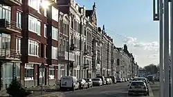 Maaskade, with Erasmus Bridge in the background | |
| Country | |
| Province | South Holland |
| COROP | Rotterdam |
| Borough | Feijenoord |
| Time zone | UTC+1 (CET) |
During the German bombings in May 1940, the Noordereiland was much better preserved than other parts of the city, because the Noordereiland was spared by the Luftwaffe, as the Germans had entrenched themselves there. However, more than 600 houses on the tips of the Noordereiland were destroyed by a number of English bombardments, which were intended to chase the Germans away.[1][2] One of the affected points, the old Prinsenhoofd, was partly excavated in 1961 to form a trench at a depth of 20 meters in the riverbed of the Nieuwe Maas during the construction of the Rotterdam Metro.[3][4] The green strip at Meeuwenstraat now bears the name Prinsenhoofd.
References
- Publicatie "Rotterdam, De Brandgrens van 14 mei 1940", Gemeente Rotterdam et al (2008), pagina 79: "Luchtaanvallen op de stad voor en na 14 mei 1940"
- Wijkhistorie: Noordereiland op de website Rotterdam Woont: Systematische documentatie van 150 jaar Rotterdamse Woningbouwprojecten
- Stadsarchief Rotterdam over de afgraving van het oude Prinsenhoofd
- http://rjb.x-cago.com/GARJB/1962/12/19621231/GARJB-19621231-0086/story.pdf (pag. 94)