Nevşehir
Nevşehir (from the Persian compound نو شهر Naw-shahr meaning "new city"), formerly Neapolis (Ancient Greek: Νεάπολις) and Muşkara, is a city and the capital district of Nevşehir Province in the Central Anatolia Region of Turkey. According to the 2010 census, the population of the district is 117,890 of which 85,634 live in the city of Nevşehir.[3][4] The district covers an area of 535 km2 (207 sq mi),[5] and the town lies at an elevation of 1,224 m (4,016 ft). In recent years, Nevşehir and the surrounding area of Cappadocia have become a huge tourist destination.
Nevşehir | |
|---|---|
 Nevşehir | |
| Coordinates: 38°37′35″N 34°42′50″E | |
| Country | Turkey |
| Province | Nevşehir |
| Government | |
| • Mayor | Rasim Arı (AKP) |
| Area | |
| • District | 534.55 km2 (206.39 sq mi) |
| Elevation | 1,224 m (4,016 ft) |
| Population (2012)[2] | |
| • Urban | 92,068 |
| • District | 123,976 |
| • District density | 230/km2 (600/sq mi) |
| Website | www.nevsehir.bel.tr |
History
A settlement was founded on the slopes of Mount Kahveci in the valley of Kızılırmak (the ancient Halys) by the Hittites. The town along with the region came under the rule of the Assyrian Empire around the 8th century BC; it was subsequently ruled by the Medes and then by the Persians in the reign of emperor Cyrus the Great in 546 BC. In 333 BC, Alexander the Great defeated the Persians. After his death, Cappadocia came under the rule of the dynasty of Ariarathes with Mazaka (present-day Kayseri) as capital. The Cappadocian kingdom became part -as province- of the Roman empire in the reign of Emperor Tiberius. It was a probable seat of the bishopric of Nyssa (Cappadocia), but that may rather be Harmandalı, Ortaköy.
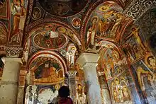
The underground shelters around Nevşehir were originally built to escape persecution by the pagan Roman authorities. Many of the churches, hewn in the rocks, date from these early years of Christianity. Even when Theodosius I made Christianity the official religion of the empire, the caves offered protection for the local people during raids by the Sassanid Persians circa AD 604 and by the Islamic Caliphate from AD 647 onwards. When Iconoclasm became state policy in the Byzantine empire, again the caves of Nevşehir became shelters for those escaping persecution.
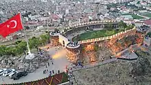
The castle on the hill dates from the Byzantine period, when the region was on the frontline in the (holy) wars against the Islamic Caliphate.
At the Battle of Manzikert (present-day Malazgirt) in AD 1071, the Byzantine emperor Romanos IV was defeated by the Seljuk Sultan Alp Arslan. This led to the occupation of Anatolia by the Seljuks by 1074 and Nevşehir along with the rest of the region became part of the Seljuk Sultanate of Rum, then under the rule of the Karamanid dynasty in 1328 and finally under rule of the Ottoman Empire around 1487 AD and was renamed "Muşkara". It remained a relatively insignificant settlement until the early 18th century.
The present-day city owes its foundation to the grand vizier and son-in-law of the Sultan Ahmed III, Nevşehirli Damat İbrahim Pasha who was born in Muşkara and therefore took a great interest in its construction as a city. The small village with only 18 houses, formerly under the administration of the kaza of Ürgüp, was rapidly transformed with the building of mosques (the Kurṣunlu Mosque), fountains, schools, soup kitchens, inns and bath houses, and its name was changed from Muşkara to "Nevşehir" (meaning New City in Persian and Ottoman Turkish).
According to the Ottoman General Census of 1881/82-1893, the kaza of Nevşehir had a total population of 39.822, consisting of 30.370 Muslims, 8.918 Greeks, 477 Armenians, 36 Catholics and 21 Protestants.[6]
According to the Convention Concerning the Exchange of Greek and Turkish Populations in 1923, the Turkish speaking Orthodox community (Karamanlis) of Nevşehir was exchanged for Muslims from Osheni, Shak and Revani villages of Kesriye (today's Οινόη, Κομνηνάδες and Διποταμία villages of Kastoria, Western Macedonia, Greece).
Nevşehir today
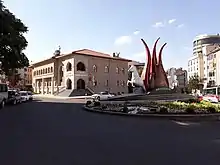
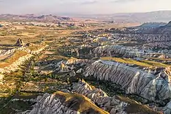
The city is located at a distance of 290 km (180 mi) from the capital Ankara, and is within the historical region of Cappadocia.
Although Nevşehir is close to the underground cities, fairy chimneys, monasteries, caravanserais and rock-hewn churches of Cappadocia, and has a few hotels, the modern town is not itself a tourist centre. In 2015 a huge underground city was discovered underneath Nevşehir town centre following demolition works intended to clear the central hillside of ramshackle modern housing.[7]
Founded in 2007, Nevşehir University was renamed Nevşehir Hacı Bektaş Veli University in 2016.
Nevşehir Kapadokya Airport (NAV) is 30 kilometres northwest of the town.
Gallery
 Nevşehir Kale exterior
 Nevsehir Kale interior
 Nevşehir Kale with underground city
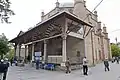 Nevşehir Damat Ibrahim Pasha complex Mosque
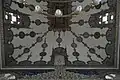 Nevşehir Damat Ibrahim Pasha Mosque
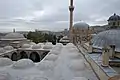 Nevşehir Damat Ibrahim Pasha complex
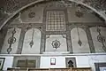 Nevşehir Damat Ibrahim Pasha complex Medrese
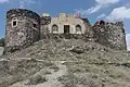
.jpg.webp) Old Greek House in Mustafapaşa
Old Greek House in Mustafapaşa.jpg.webp) Old Greek Church in Mustafapaşa
Old Greek Church in Mustafapaşa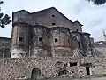 Virgin Mary Church, Nevşehir
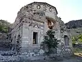 Roman Bath in Nevşehir
 Nevşehir museum Middle bronze age 2000-1200 BC
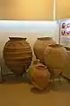 Nevşehir museum Late Byzantine earthenware vessel
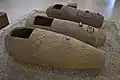 Nevşehir museum Terracotta sarcophagi 3rd-4th centuries AD
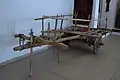 Nevşehir museum Oxcart
 Nevşehir town view
Sports
A multiday track running ultramarathon of desert concept, called Runfire Cappadocia Ultramarathon, is held since 2012 annually in July. The race tours 244 km (152 mi) in six days through several historic places across Cappadocia reaching out to Lake Tuz.[8]
Climate
Nevşehir has a continental climate (Köppen climate classification: Dsa, Trewartha climate classification: Dc), with cold, snowy winters and warm, dry summers. Rainfall occurs throughout the year, with a slight peak in spring.
| Climate data for Nevşehir (1991–2020, extremes 1959–2020) | |||||||||||||
|---|---|---|---|---|---|---|---|---|---|---|---|---|---|
| Month | Jan | Feb | Mar | Apr | May | Jun | Jul | Aug | Sep | Oct | Nov | Dec | Year |
| Record high °C (°F) | 18.6 (65.5) |
19.6 (67.3) |
28.0 (82.4) |
31.6 (88.9) |
32.6 (90.7) |
35.0 (95.0) |
39.5 (103.1) |
38.2 (100.8) |
37.4 (99.3) |
32.0 (89.6) |
27.6 (81.7) |
23.0 (73.4) |
39.5 (103.1) |
| Average high °C (°F) | 4.1 (39.4) |
6.0 (42.8) |
10.9 (51.6) |
16.3 (61.3) |
21.2 (70.2) |
25.6 (78.1) |
29.3 (84.7) |
29.4 (84.9) |
25.3 (77.5) |
19.1 (66.4) |
11.6 (52.9) |
6.2 (43.2) |
17.1 (62.8) |
| Daily mean °C (°F) | 0.0 (32.0) |
1.3 (34.3) |
5.5 (41.9) |
10.4 (50.7) |
15.0 (59.0) |
18.9 (66.0) |
22.2 (72.0) |
22.1 (71.8) |
18.1 (64.6) |
12.8 (55.0) |
6.3 (43.3) |
2.0 (35.6) |
11.2 (52.2) |
| Average low °C (°F) | −3.5 (25.7) |
−2.6 (27.3) |
1.0 (33.8) |
5.2 (41.4) |
9.3 (48.7) |
12.3 (54.1) |
14.6 (58.3) |
14.5 (58.1) |
11.3 (52.3) |
7.4 (45.3) |
2.1 (35.8) |
−1.4 (29.5) |
5.9 (42.6) |
| Record low °C (°F) | −21.2 (−6.2) |
−23.6 (−10.5) |
−18.0 (−0.4) |
−12.5 (9.5) |
−2.3 (27.9) |
1.3 (34.3) |
3.8 (38.8) |
3.1 (37.6) |
−1.2 (29.8) |
−7.6 (18.3) |
−14.0 (6.8) |
−19.5 (−3.1) |
−23.6 (−10.5) |
| Average precipitation mm (inches) | 43.7 (1.72) |
41.8 (1.65) |
47.5 (1.87) |
45.7 (1.80) |
57.4 (2.26) |
37.5 (1.48) |
9.9 (0.39) |
9.6 (0.38) |
13.7 (0.54) |
29.4 (1.16) |
33.4 (1.31) |
48.4 (1.91) |
418.0 (16.46) |
| Average precipitation days | 8.80 | 7.83 | 10.27 | 11.33 | 13.40 | 8.40 | 2.40 | 2.37 | 3.83 | 6.93 | 7.10 | 9.30 | 92.0 |
| Mean monthly sunshine hours | 96.1 | 118.7 | 164.3 | 204.0 | 257.3 | 309.0 | 365.8 | 347.2 | 276.0 | 195.3 | 138.0 | 86.8 | 2,558.5 |
| Mean daily sunshine hours | 3.1 | 4.2 | 5.3 | 6.8 | 8.3 | 10.3 | 11.8 | 11.2 | 9.2 | 6.3 | 4.6 | 2.8 | 7.0 |
| Source: Turkish State Meteorological Service[9] | |||||||||||||
Notes
- "Area of regions (including lakes), km²". Regional Statistics Database. Turkish Statistical Institute. 2002. Retrieved 2013-03-05.
- "Population of province/district centers and towns/villages by districts - 2012". Address Based Population Registration System (ABPRS) Database. Turkish Statistical Institute. Retrieved 2013-02-27.
- Statistical Institute
- GeoHive. "Statistical information on Turkey's administrative units". Retrieved 2008-04-12.
- Statoids. "Statistical information on districts of Turkey". Retrieved 2008-04-12.
- Kemal Karpat (1985), Ottoman Population, 1830-1914, Demographic and Social Characteristics, The University of Wisconsin Press, p. 142-143
- "Massive Underground City Found in Cappadocia Region of Turkey". Adventure. 2015-03-26. Retrieved 2022-04-11.
- "Elite Athletes to run at The Runfire Cappadocia". Istanbul Convention & Visitors Bureau. July 2013. Archived from the original on 2013-08-05. Retrieved 2013-11-28.
- "Resmi İstatistikler: İllerimize Ait Mevism Normalleri (1991–2020)" (in Turkish). Turkish State Meteorological Service. Retrieved 6 July 2021.
References
- Falling Rain Genomics, Inc. "Geographical information on Nevşehir, Turkey". Retrieved 2008-04-12.
- Kenthaber.com. "General information on Nevşehir, Turkey" (in Turkish). Archived from the original on 2011-09-28. Retrieved 2008-04-12.
External links
| Wikimedia Commons has media related to Nevşehir. |
- Nevşehir Travel governor's official website (in Turkish)
- Nevşehir governor's official website (in Turkish)
- Nevşehir municipality's official website (in Turkish)
- Nevşehir (in Turkish)
- Some 200 pictures of the town and its sights
- Administrative map of Nevşehir district (in Turkish)
Nevşehir in Nevşehir Province of Turkey | |||||||||||||||||||||||||||
|---|---|---|---|---|---|---|---|---|---|---|---|---|---|---|---|---|---|---|---|---|---|---|---|---|---|---|---|
| Districts | 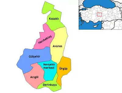 Districts of Nevşehir | ||||||||||||||||||||||||||
| |||||||||||||||||||||||||||
Metropolitan municipalities are bolded. | |||||||||||||||||||||||||||