Milton Keynes urban area
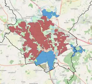
The Milton Keynes urban area or Milton Keynes Built-up Area is a designation established by the United Kingdom's Office for National Statistics.[1][lower-alpha 1] As with other urban areas, it includes settlements that are physically contiguous with the rest of the built up area but, for historical reasons, regard themselves as being outside of the principal settlement: this urban area includes Newport Pagnell and Woburn Sands.[1]
Built-up area sub-divisions
2011
These are the 'built-up area subdivisions' of the Milton Keynes urban area (built-up area) as defined by the ONS for the 2011 census :
| Subdivision | Population (2011 census)[1] | Notes |
|---|---|---|
| "Milton Keynes" | 171,750[2][lower-alpha 2] | This figure is for the remainder of Milton Keynes after deducting Bletchley, which has been part of Milton Keynes since its designation in 1967. The ONS does not give any reason for having done this. Also includes Wavendon, which is outside the designated area of Milton Keynes. |
| Bletchley | 37,114[3] | |
| Newport Pagnell | 15,118[4] | |
| Woburn Sands | 5,959[5] | Includes the villages of Aspley Guise and Aspley Heath in Bedfordshire, which lie outside the Borough of Milton Keynes (and Buckinghamshire) |
| Total | 229,941[1] |
2001
In defining the sub-areas of the Milton Keynes urban area for the 2001 census, the ONS used the pre-designation urban and rural districts, subdividing the larger rural district by the chronological phases of urbanisation within them). (These designations were largely dropped for the 2011 Census.) These were:
- Bletchley Urban District
- Wolverton Urban District
- Newport Pagnell Urban District
- Newport Pagnell Rural District
The corresponding 2001 Urban Sub-areas were:
Bletchley
This area approximates to the boundaries of the former Bletchley Urban District Council at the time of the designation of Milton Keynes. In outline, the ONS Sub-area consisted of Bletchley and Fenny Stratford Civil Parish, West Bletchley Civil Parish and part of Shenley Brook End Civil Parish (specifically Furzton, Emerson Valley, Tattenhoe and Snelshall).[6]
Wolverton and Stony Stratford
The area covered by this enumeration district approximated to that of the former Wolverton Urban District and included Stony Stratford CP, Wolverton and Greenleys CP, New Bradwell CP, Stantonbury CP and part of Great Linford CP.[7]
Newport Pagnell
This sub-area is the same as that of the former Newport Pagnell urban district, excluding any part west of the M1 Motorway (which was transferred to the 'Milton Keynes North' area).
Central and North Milton Keynes
The 'Central Milton Keynes' and the 'North Milton Keynes' sub-areas together map to that part of the former Newport Pagnell Rural District that is west of the River Ouzel. The 'Walnut Tree' and 'Browns Wood' sub-areas together cover the remainder of the Rural District from the Ouzel to the M1. The areas covered by these names are far larger than the civil parishes of the same name, except for 'North Milton Keynes', which does not exist otherwise.
The Central Milton Keynes urban sub-area enumeration district covered an area far larger than Central Milton Keynes Civil Parish. The precise boundaries are no longer readily available.[8] The fragment of Winslow Rural in the designated area, Shenley Church End, was added to "Central Milton Keynes Urban Sub-area".
The North Milton Keynes urban sub-area consisted of the modern part of Bradwell, Rooksley, half of Bradwell Common, Linford Wood, half of Downs Barn, Downhead Park, Willen and Tongwell.
Walnut Tree
This area covered approximately the districts within an area bounded by the River Ouzel, Standing Way, the former A5130, and Bletcham Way.[lower-alpha 3]
Browns Wood
This area covered approximately the districts within an area bounded by the Ouzel, Bletcham Way, the former A5130, and the Marston Vale line.[lower-alpha 3]
Calculation of population
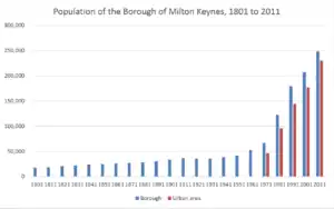
The population of Milton Keynes's Built-up Area was 229,941 according to the 2011 census.[1] This was an increase of almost 25% on the population recorded in the 2001 census of 184,506.[9]
Notes
- For the ONS definition of a 'built-up area' or 'urban area', see List of urban areas in the United Kingdom#Definition
- Although Milton Keynes was specified to be a city in scale and the term "city" is used locally (inter alia to avoid confusion with its constituent towns), formally this title cannot be used. This is because conferment of city status in the United Kingdom is a Royal prerogative.
- As of March 2020, the precise boundaries are no longer readily available
References
- UK Census (2011). "Local Area Report – Milton Keynes Built-up area (E34005056)". Nomis. Office for National Statistics. Retrieved 29 March 2019.
- UK Census (2011). "Local Area Report – Rest of Milton Keynes (1119885224)". Nomis. Office for National Statistics. Retrieved 1 January 2019.
- UK Census (2011). "Local Area Report – Bletchley (1119884613)". Nomis. Office for National Statistics. Retrieved 1 January 2019.
- UK Census (2011). "Local Area Report – Newport Pagnell (1119884932)". Nomis. Office for National Statistics. Retrieved 1 January 2019.
- UK Census (2011). "Local Area Report – Woburn Sands (1119884061)". Nomis. Office for National Statistics. Retrieved 1 January 2019.
- Map of Bletchley USa As of March 2020, the 2001 boundaries are no longer shown, invalidating this citation.
- Map of Wolverton/Stony Stratford Urban Sub-area As of March 2020, the 2001 boundaries are no longer shown, invalidating this citation.
- Map of Central Milton Keynes enumeration district As of March 2020, the 2001 boundaries are no longer shown, invalidating this citation.
- "Census 2001 Key Statistics, Urban areas in England and Wales" (PDF). ONS. Retrieved 3 July 2013.