Mid-Western Highway
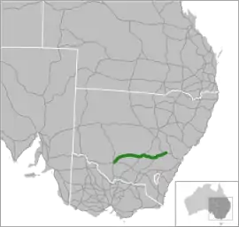
The Mid-Western Highway, sometimes the Mid Western Highway,[2] is a 522-kilometre (324 mi)[1] state highway located in the central western and northern Riverina regions of New South Wales, Australia. The highway services rural communities and links the Great Western, Mitchell, Olympic, Newell, Cobb and Sturt highways. The Mid-Western Highway forms part of the most direct route road link between Sydney and Adelaide,[3][4] with its eastern terminus in Bathurst and western terminus in Hay.
Mid-Western Highway | |
|---|---|
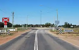 | |
| A level crossing of the Mid-Western Highway near Goolgowi, with a roundabout connecting with Kidman Way in the background. | |
 | |
| General information | |
| Type | Highway |
| Length | 522 km (324 mi)[1] |
| Opened | 1928 |
| Route number(s) |
|
| Former route number | Entire route |
| Major junctions | |
| West end | Hay, New South Wales |
| East end | Bathurst, New South Wales |
| Location(s) | |
| Major settlements | Goolgowi, Rankins Springs, West Wyalong, Grenfell, Cowra, Blayney |
| Highway system | |
Gazetted and named as a state highway in August 1928, the Mid-Western Highway carries the National Highway shield A41 between Bathurst and Cowra and the State Route B64 shield between Cowra and Hay. The highway shares a concurrency with the Newell Highway between Mardsden and West Wyalong.[5] The highway is a single carriageway along its entire length.
During 2014 the Roads & Maritime Services in conjunction with the NSW Geographical Names Board commenced a consultation process to change the name of the highway to the Wiradjuri Highway,[2] as the only state highway to lie fully within the Wiradjuri cultural area.[6]
Route
The highway runs generally northeast-southwest, roughly aligned to the Lachlan River in New South Wales, then stretching across the Hay Plain, generally towards the south-western corner of New South Wales.
The eastern terminus of the Mid-Western Highway is at a junction with the Great Western Highway and Mitchell Highway in the city of Bathurst. Heading west by southwest, the highway carries the A41 shield and passes through Blayney, Carcoar where the village is bypassed in 1975,[5] and to Cowra where the highway crosses the Lachlan River and forms the northern terminus of the Olympic Highway and provides access to the Lachlan Valley Way. At Cowra the highway heads west, carrying the State Route B64 shield to Grenfell with a link to the Henry Lawson Way as the Mid-Western Highway heads further west to its junction with the Newell Highway at Marsden. From Mardsen to West Wyalong the route is concurrently badged as B64 and as the National Highway A39. The Mid-Western Highway and Newell concurrency terminates west of West Wyalong and the Mid-Western continues further west through Weethalle, and then southwest to Rankins Springs and Goolgowi before reaching its western terminus in Hay where it joins the Sturt Highway via the Cobb Highway.[5]
Following the upgrade of the Hume Highway to a dual carriageway along the vast majority of its length in New South Wales and the declaration of the Sturt Highway as a national highway, despite the Mid-Western Highway being the most direct route between Sydney and Adelaide, the route via the Hume and Sturt highways through Wagga Wagga offers motorists a quicker route, despite being approximately 20 kilometres (12 mi) longer.[7]
The only major river crossing is the Lachlan River at Cowra.
Major intersections
| LGA | Location | km[1] | mi | Destinations | Notes |
|---|---|---|---|---|---|
| Bathurst | Bathurst | 0 | 0.0 | Eastern highway terminus | |
| Eastern highway terminus | |||||
| Cowra | Cowra | 104 | 65 | Lachlan Valley Way (B81) concurrency terminus | |
| Lachlan River | Cowra Bridge | ||||
| Cowra | Cowra | 105 | 65 | Lachlan Valley Way (B81) concurrency terminus | |
| Weddin | Grenfell | 158 | 98 | Henry Lawson Way (southeast) – Young | Henry Lawson Way eastern concurrency terminus |
| 167 | 104 | Henry Lawson Way (northwest) – Forbes | Henry Lawson Way western concurrency terminus | ||
| Bland | Marsden | 227 | 141 | Eastern concurrency terminus with the Newell Highway (A39) | |
| Wyalong | 259 | 161 | |||
| West Wyalong | 265 | 165 | Western concurrency terminus with the Newell Highway (A39) | ||
| Ungarie Road – Ungarie, Condobolin, Lake Cargelligo | |||||
| Carrathool | Goolgowi | 411 | 255 | Roundabout | |
| Hay | Hay | 520 | 320 | Western highway terminus | |
| Western highway terminus | |||||
| 522 | 324 | ||||
1.000 mi = 1.609 km; 1.000 km = 0.621 mi
| |||||
References
- Google (3 April 2015). "Mid-Western Highway" (Map). Google Maps. Google. Retrieved 3 April 2015.
- "Proposal to rename the Mid Western Highway". Roads & Maritime Services. Government of New South Wales. 10 December 2014. Retrieved 3 April 2015.
- Rands, Paul (10 November 2013). "Mid Western Highway (B64)". Road Photos & Information: New South Wales. Expressway: The Australian Highway Site. Retrieved 3 April 2015.
- Rands, Paul (7 December 2013). "Mid Western Highway & Olympic Highway (A41)". Road Photos & Information: New South Wales. Expressway: The Australian Highway Site. Retrieved 3 April 2015.
- "Mid-Western Highway". Ozroads. Retrieved 17 June 2013.
- Mid Western Highway/Wiradjuri map (PDF) (Map). Roads & Maritime Services, Government of New South Wales. 2014. Archived from the original (PDF) on 2 April 2015. Retrieved 3 April 2015.
- "Sturt Highway". Ozroads. Retrieved 25 May 2008.
External links
| Wikimedia Commons has media related to Mid-Western Highway. |