Meslières
Meslières (French pronunciation: [mɛljɛʁ]) is a commune in the Doubs département in the Bourgogne-Franche-Comté region in eastern France.
Meslières | |
|---|---|
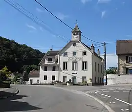 The town hall in Meslières | |
 Coat of arms | |
Location of Meslières 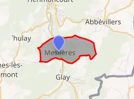 | |
 Meslières  Meslières | |
| Coordinates: 47°25′05″N 6°53′19″E | |
| Country | France |
| Region | Bourgogne-Franche-Comté |
| Department | Doubs |
| Arrondissement | Montbéliard |
| Canton | Maîche |
| Intercommunality | Pays de Montbéliard Agglomération |
| Government | |
| • Mayor (2020–2026) | Christian Methot[1] |
| Area 1 | 2.99 km2 (1.15 sq mi) |
| Population | 346 |
| • Density | 120/km2 (300/sq mi) |
| Time zone | UTC+01:00 (CET) |
| • Summer (DST) | UTC+02:00 (CEST) |
| INSEE/Postal code | 25378 /25310 |
| Elevation | 374–577 m (1,227–1,893 ft) |
| 1 French Land Register data, which excludes lakes, ponds, glaciers > 1 km2 (0.386 sq mi or 247 acres) and river estuaries. | |
Geography
The commune lies 3 km (1.9 mi) south of Hérimoncourt. The population is divided between the valley of the Gland River and the plateau.
Population
| Year | Pop. | ±% |
|---|---|---|
| 1962 | 308 | — |
| 1968 | 350 | +13.6% |
| 1975 | 340 | −2.9% |
| 1982 | 388 | +14.1% |
| 1990 | 375 | −3.4% |
| 1999 | 353 | −5.9% |
| 2008 | 352 | −0.3% |
| 2012 | 362 | +2.8% |
See also
References
- "Répertoire national des élus: les maires". data.gouv.fr, Plateforme ouverte des données publiques françaises (in French). 2 December 2020.
- "Populations légales 2019". The National Institute of Statistics and Economic Studies. 29 December 2021.
External links
| Wikimedia Commons has media related to Meslières. |
- Official website (in French)
- Meslières on the intercommunal Web site of the department (in French)
This article is issued from Wikipedia. The text is licensed under Creative Commons - Attribution - Sharealike. Additional terms may apply for the media files.