Matamata-Piako District
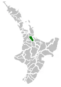
Matamata-Piako District is a local government area in the Waikato region of New Zealand. It lies to the east of the city of Hamilton.
Matamata-Piako District | |
|---|---|
 Te Aroha | |
 | |
| Country | New Zealand |
| Region | Waikato |
| Wards | Matamata Morrinsville Te Aroha |
| Seat | Te Aroha |
| Government | |
| • Mayor | Ash Tanner [1] |
| • Deputy Mayor | Neil Goodger[1] |
| • Territorial authority | Matamata-Piako District Council |
| Area | |
| • Land | 1,755.35 km2 (677.74 sq mi) |
| Population (June 2021)[3] | |
| • Total | 36,700 |
| Time zone | UTC+12 (NZST) |
| • Summer (DST) | UTC+13 (NZDT) |
| Postcode(s) | |
| Website | Matamata-Piako District Council |
Geography
The district encompasses the southern end of the Hauraki Plains and much of the Thames Valley, and is bounded in the east by the Kaimai Range. The rivers Piako and Waihou run through the district.
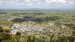
The towns of Matamata, Morrinsville and Te Aroha are all within the district, with the Council's head office based in Te Aroha. The main industry in the region is dairy farming and Thoroughbred breeding and training. Other communities in the district include Mangateparu and Waitoa.
Populated places
Matamata-Piako District consists of the following towns, localities, settlements and communities:
|
|
Demographics
Matamata-Piako District covers 1,755.35 km2 (677.74 sq mi)[2] and had an estimated population of 36,700 as of June 2021,[3] with a population density of 20.9 people per km2. 8,410 people live in Morrinsville, 8,570 in Matamata, and 4,650 in Te Aroha.
| Year | Pop. | ±% p.a. |
|---|---|---|
| 2006 | 30,483 | — |
| 2013 | 31,536 | +0.49% |
| 2018 | 34,404 | +1.76% |
| Source: [4] | ||
Matamata-Piako District had a population of 34,404 at the 2018 New Zealand census, an increase of 2,868 people (9.1%) since the 2013 census, and an increase of 3,921 people (12.9%) since the 2006 census. There were 12,873 households. There were 17,001 males and 17,403 females, giving a sex ratio of 0.98 males per female. The median age was 40.8 years (compared with 37.4 years nationally), with 6,999 people (20.3%) aged under 15 years, 6,186 (18.0%) aged 15 to 29, 14,436 (42.0%) aged 30 to 64, and 6,783 (19.7%) aged 65 or older.
Ethnicities were 84.4% European/Pākehā, 16.7% Māori, 2.1% Pacific peoples, 5.7% Asian, and 1.7% other ethnicities. People may identify with more than one ethnicity.
The percentage of people born overseas was 14.4, compared with 27.1% nationally.
Although some people objected to giving their religion, 51.4% had no religion, 35.8% were Christian, 0.8% were Hindu, 0.3% were Muslim, 0.9% were Buddhist and 2.8% had other religions.
Of those at least 15 years old, 3,204 (11.7%) people had a bachelor or higher degree, and 7,203 (26.3%) people had no formal qualifications. The median income was $32,400, compared with $31,800 nationally. 4,221 people (15.4%) earned over $70,000 compared to 17.2% nationally. The employment status of those at least 15 was that 13,566 (49.5%) people were employed full-time, 4,077 (14.9%) were part-time, and 876 (3.2%) were unemployed.[4]
| Name | Area (km2) | Population | Density (per km2) | Households | Median age | Median income |
|---|---|---|---|---|---|---|
| Morrinsville Ward | 573.00 | 12,501 | 21.82 | 4,608 | 38.6 years | $35,200 |
| Te Aroha Ward | 517.10 | 8,268 | 15.99 | 3,126 | 43.3 years | $29,300 |
| Matamata Ward | 665.24 | 13,635 | 20.50 | 5,142 | 41.4 years | $31,800 |
| New Zealand | 37.4 years | $31,800 |
References
- "Councillors and Mayor". www.mpdc.govt.nz. Retrieved 25 April 2020.
- "ArcGIS Web Application". statsnz.maps.arcgis.com. Retrieved 1 March 2022.
- "Population estimate tables - NZ.Stat". Statistics New Zealand. Retrieved 22 October 2021.
- "Statistical area 1 dataset for 2018 Census". Statistics New Zealand. March 2020. Matamata-Piako District (015). 2018 Census place summary: Matamata-Piako District
- "Sister City Agreement". Archived from the original on 6 February 2011. Retrieved 10 July 2009.