Maricourt, Somme
Maricourt (French pronunciation: [maʁikuʁ]) is a commune in the Somme department in Hauts-de-France in northern France. It is twinned with Brundall, Norfolk, England.
Maricourt | |
|---|---|
 The British war cemetery in Maricourt | |
Location of Maricourt 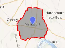 | |
 Maricourt  Maricourt | |
| Coordinates: 49°58′52″N 2°47′09″E | |
| Country | France |
| Region | Hauts-de-France |
| Department | Somme |
| Arrondissement | Péronne |
| Canton | Albert |
| Intercommunality | Pays du Coquelicot |
| Government | |
| • Mayor (2020–2026) | Bernard Guillemont[1] |
| Area 1 | 7.52 km2 (2.90 sq mi) |
| Population | 180 |
| • Density | 24/km2 (62/sq mi) |
| Time zone | UTC+01:00 (CET) |
| • Summer (DST) | UTC+02:00 (CEST) |
| INSEE/Postal code | 80513 /80360 |
| Elevation | 55–129 m (180–423 ft) (avg. 125 m or 410 ft) |
| 1 French Land Register data, which excludes lakes, ponds, glaciers > 1 km2 (0.386 sq mi or 247 acres) and river estuaries. | |
Geography
Maricourt is situated on the D938 road, some 30 miles (48 km) southeast of Amiens.
Population
|
|
The Commonwealth Cemetery

The Commonwealth Cemetery
See also
References
- "Répertoire national des élus: les maires". data.gouv.fr, Plateforme ouverte des données publiques françaises (in French). 2 December 2020.
- "Populations légales 2019". The National Institute of Statistics and Economic Studies. 29 December 2021.
| Wikimedia Commons has media related to Maricourt. |
This article is issued from Wikipedia. The text is licensed under Creative Commons - Attribution - Sharealike. Additional terms may apply for the media files.