Parvathipuram Manyam district
Parvathipuram Manyam district is a district in the Indian state of Andhra Pradesh. With Parvathipuram as its administrative headquarters, it became functional from 4th April 2022. It became one of the resultant twenty-six districts in the state and final notification is issued by the government of Andhra Pradesh. The district is formed from Parvathipuram revenue division from Vizianagaram district and part of Palakonda revenue division of Srikakulam district.[3][4][5][6]
Parvathipuram Manyam district | |
|---|---|
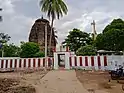 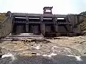    Kamalingeshwara Temple in Gallavilli, Pedda Gedda Dam, Vegavathi River at Salur, View of Eastern Ghats from Parvathipuram, View near Palakonda | |
.svg.png.webp) | |
| Coordinates: 18.8°N 83.4°E | |
| Country | |
| State | Andhra Pradesh |
| Headquarters | Parvathipuram |
| Area | |
| • Total | 3,659 km2 (1,413 sq mi) |
| Population | |
| • Total | 925,340 |
| • Density | 250/km2 (650/sq mi) |
| Time zone | UTC+05:30 (IST) |
| Website | parvathipurammanyam |
Administratve divisions
The district has two revenue divisions, namely Palakonda and Parvathipuram, each headed by a sub collector. These revenue divisions are divided into 15 mandals.
Mandals
There are 7 mandals in Palakonda division and 8 in Parvathipuram division. The 16 mandals under their revenue divisions are listed below:
Demographics
At the time of the 2011 census the district had a population of 9,25,340. Scheduled Castes and Scheduled Tribes make up 1,10,169 (11.91%) and 260,419 (28.14%) of the population respectively.[1][2]
At the time of the 2011 census, 89.00% of the population spoke Telugu, 5.86% Saora and 2.15% Jatapu as their first language.[9]
References
- "District Census Handbook 2011 - Srikakulam" (PDF). censusindia.gov.in. Office of the Registrar General & Census Commissioner, India. 2011.
- "District Census Handbook - Vizianagaram" (PDF). censusindia.gov.in. Office of the Registrar General & Census Commissioner, India. 2011.
- Raghavendra, V. (26 January 2022). "With creation of 13 new districts, AP now has 26 districts". The Hindu. ISSN 0971-751X. Archived from the original on 26 January 2022. Retrieved 26 January 2022.
- "AP issues draft gazette notification on 26 districts". Deccan Chronicle. 26 January 2022. Archived from the original on 29 January 2022. Retrieved 11 February 2022.
- "New districts to come into force on April 4". The Hindu. 30 March 2022. Retrieved 31 March 2022.
{{cite web}}: CS1 maint: url-status (link) - "కొత్త జిల్లా తాజా స్వరూపం". Eenadu.net (in Telugu). 31 March 2022. Retrieved 31 March 2022.
{{cite web}}: CS1 maint: url-status (link) - "District-wise Assembly-Constituencies". ceoandhra.nic.in.
- "Population by Religion - Andhra Pradesh". censusindia.gov.in. Office of the Registrar General & Census Commissioner, India. 2011.
- "Table C-16: Population by Mother Tongue". www.censusindia.gov.in.
| Topics | |||
|---|---|---|---|
| Regions | |||
| Districts | |||
| Million-plus cities | |||
| Cities (population over 1 lakh) |
| ||
| Tourism |
| ||
| History | |||
| Related lists | |||
| |||