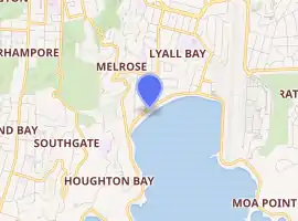
Lyall Bay
Lyall Bay is a bay and a suburb on the south side of the Rongotai isthmus in Wellington, New Zealand.
Suburb of Wellington City | |
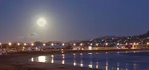 Full moon over the bay | |
 | |
| Country | New Zealand |
| City | Wellington City |
| Electoral ward | Motukairangi/Eastern Ward |
| Area | |
| • Land | 55 ha (136 acres) |
| Population (June 2021)[3] | |
| • Total | 2,750 |
| Airport(s) | Wellington International Airport |
| Kilbirnie | Kilbirnie | Rongotai |
| Melrose |
|
Rongotai |
| (Cook Strait) | Moa Point |
The bay is a popular surf beach, featuring a breakwater at the eastern end. It has also been the site of surf lifesaving championships, and is home to two surf lifesaving clubs. Lyall Bay is a very popular and safe swimming beach. The beach is only two thirds of its original size; the construction of Wellington International Airport took away the eastern third of the beach.
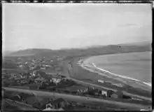
The suburb consists of most of the southern half of the Rongotai isthmus, although Wellington International Airport and a small industrial area next to it are often considered to be part of Rongotai. The suburb was initially named Maranui by H D Crawford and H M Hayward, who began selling sections for a new township at the bay in 1896.[4]
Lyall Bay was probably the ancient mouth of the Hutt River.[5] The current isthmus was created by geologic upheaval as result of recurring earthquakes, the most recent occurrence being the 1855 Wairarapa earthquake.[6]
Lyall Bay is predominantly a residential area, but also contains a part of Wellington's Southern Walkway, and the Southern Headlands Reserve, and Wellington's largest beach. The south-western border has Te Raekaihau Point as the dividing landform to Houghton Bay.
The suburb has a bus service and is near to the Kilbirnie shopping centre and the Tirangi Road Airport Retail Park. There is a primary school (Lyall Bay School), a Playcentre, a lawn bowls club, two surf clubs, and a small range of shops.
The suburb is also home to Fat Freddy's Drop, a popular Wellington band.
Etymology
Lyall Bay was earlier known as False Bay, because ships would mistake the bay for the entrance to Wellington Harbour.[7] The Māori name for the beach was Huetepara, which literally means 'gourd' (hue), 'the' (te), and 'ripe' (para).[1]
There is uncertainty around the etymology of Lyall Bay. Some believe that it is named after Dr David Lyall of the survey ship HMS Acheron, but he didn't serve on that ship until 1847,[8] by which time the name Lyall Bay was already in use. Another theory is that it is named after George Lyall, one of the directors of the New Zealand Company.[1]
Demographics
Lyall Bay statistical area covers 0.55 km2 (0.21 sq mi).[2] It had an estimated population of 2,750 as of June 2021,[3] with a population density of 5,000 people per km2.
| Year | Pop. | ±% p.a. |
|---|---|---|
| 2006 | 2,580 | — |
| 2013 | 2,595 | +0.08% |
| 2018 | 2,673 | +0.59% |
| Source: [9] | ||
Lyall Bay had a population of 2,673 at the 2018 New Zealand census, an increase of 78 people (3.0%) since the 2013 census, and an increase of 93 people (3.6%) since the 2006 census. There were 1,029 households. There were 1,275 males and 1,401 females, giving a sex ratio of 0.91 males per female. The median age was 36.5 years (compared with 37.4 years nationally), with 480 people (18.0%) aged under 15 years, 573 (21.4%) aged 15 to 29, 1,353 (50.6%) aged 30 to 64, and 267 (10.0%) aged 65 or older.
Ethnicities were 71.2% European/Pākehā, 13.0% Māori, 8.5% Pacific peoples, 16.8% Asian, and 4.6% other ethnicities (totals add to more than 100% since people could identify with multiple ethnicities).
The proportion of people born overseas was 27.7%, compared with 27.1% nationally.
Although some people objected to giving their religion, 51.2% had no religion, 31.6% were Christian, 4.8% were Hindu, 1.7% were Muslim, 1.0% were Buddhist and 3.8% had other religions.
Of those at least 15 years old, 831 (37.9%) people had a bachelor or higher degree, and 279 (12.7%) people had no formal qualifications. The median income was $39,600, compared with $31,800 nationally. The employment status of those at least 15 was that 1,263 (57.6%) people were employed full-time, 321 (14.6%) were part-time, and 78 (3.6%) were unemployed.[9]
Education
Lyall Bay School is a co-educational state primary school for Year 1 to 6 students,[10][11] with a roll of 348 as of March 2022.[12]
References
- Reed, A. W. (2010). Peter Dowling (ed.). Place Names of New Zealand. Rosedale, North Shore: Raupo. ISBN 9780143204107.
- "ArcGIS Web Application". statsnz.maps.arcgis.com. Retrieved 1 July 2021.
- "Population estimate tables - NZ.Stat". Statistics New Zealand. Retrieved 22 October 2021.
- "[untitled]". Evening Post. 3 October 1896. Retrieved 3 June 2021 – via Paperspast.
- Graeme R. Stevens, 1974, Rugged Landscape The Geology of Central New Zealand, A H and A W Reed Ltd.
- Gardner, J. & Bell, J. [Eds.] 2008. The Taputeranga Marine Reserve, Wellington, NZ., 532 pp.
- "Chart of Port Nicholson". New Zealand Gazette and Wellington Spectator. 12 September 1840. Retrieved 3 June 2021 – via Paperspast.
- Hooker, J. D. (11 March 1996). "David Lyall (1817-1895)". Botanical Electronic News (Reproduction of obituary in J. Bot. 33: 209-211. 1895). Retrieved 3 June 2021.
{{cite web}}: CS1 maint: url-status (link) - "Statistical area 1 dataset for 2018 Census". Statistics New Zealand. March 2020. Lyall Bay (254300). 2018 Census place summary: Lyall Bay
- "Lyall Bay School Official School Website". lyallbay.school.nz.
- "Lyall Bay School Education Review Office Report". ero.govt.nz. Education Review Office.
- "Lyall Bay School Ministry of Education School Profile". educationcounts.govt.nz. Ministry of Education.