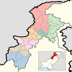
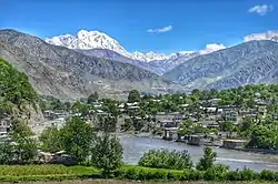
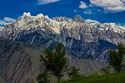
Lower Chitral District
Lower Chitral District (Pashto: چترال لر / کوز ولسوالۍ, Urdu: ضلع چترال زیریں) is a district in Malakand Division of Khyber Pakhtunkhwa province in Pakistan.[2]
Lower Chitral District
ضلع چترال زیریں | |
|---|---|
  | |
.svg.png.webp) Location of Lower Chitral District in the Khyber Pakhtunkhwa province | |
| Country | |
| Province | |
| Division | Malakand |
| Established | 2018 |
| Headquarters | Chitral |
| Government | |
| • Type | District Administration |
| • Deputy Commissioner | N/A |
| • District Police Officer | N/A |
| • District Health Officer | N/A |
| Area | |
| • Total | 6,458 km2 (2,493 sq mi) |
| Population | |
| • Total | 278,328 |
| • Density | 43/km2 (110/sq mi) |
| Time zone | UTC+5 (PST) |
| Number of Tehsils | 2 |
| Website | www.khyberpakhtunkhwa.gov.pk |
Demographics
At the time of the 2017 census the district had a population of 278,328, of which 143,676 were males and 134,637 females. Rural population was 228,548 (82.11%) while the urban population was 49,780 (17.89%). The literacy rate was 63.00% - the male literacy rate was 75.71% while the female literacy rate was 49.37%. 3,902 (1.40%) were from religious minorities, almost all of whom are followers of the indigenous animistic Kalash faith that was once the dominant faith in the district before the spread of Islam.[1]
89.48% of the population spoke languages recorded as 'Other' on the census. Most of these spoke Khowar (or Chitrali), the dominant language of Chitral as a whole. A minority spoke Chitral Kalasha and Wakhi, with the Kalasha dominating several valleys and the Wakhis spread throughout the north of the district near the Afghan border. Pashto is spoken in the southeast of the district by 9.11% of the population.[1]
References
- "District Wise Results / Tables (Census - 2017)". www.pbscensus.gov.pk. Pakistan Bureau of Statistics.
- "Upper Chitral gets status of separate district". dawn.com. 21 November 2018. Retrieved 15 August 2020.