Loch Beannach, Assynt
Loch Beannach is a small v-shaped loch, located 2 miles to the west of Loch Assynt and 3 miles northeast of Lochinver within the Assynt area of Sutherland, Scotland.[3][2] [1] The loch is located in an area known as the Assynt-Coigach National Scenic Area,[4] one of 40 such areas in Scotland.[5]
| Loch Beannach, Assynt | |
|---|---|
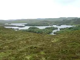 Loch Beannach in the Little Assynt Estate. Native woodland survives on the islands | |
 Loch Beannach, Assynt | |
| Location | NC13852637 |
| Coordinates | 58.18889999°N 5.16194439°W |
| Type | freshwater loch |
| Max. length | 2.00 km (1.24 mi)[1] |
| Max. width | 0.53 km (0.33 mi)[1] |
| Surface area | 49 ha (120 acres)[2] |
| Average depth | 13.45 ft (4.10 m)[1] |
| Max. depth | 32 ft (9.8 m)[1] |
| Water volume | 70,883,210.58 cu ft (2,007,189.000 m3)[1] |
| Shore length1 | 100 km (62 mi) [2] |
| Surface elevation | 68 m (223 ft)[2] |
| Max. temperature | 52.5 °F (11.4 °C) |
| Min. temperature | 52.00 °F (11.11 °C) |
| Islands | 21 |
| 1 Shore length is not a well-defined measure. | |
Conservation
The northeastern part of the loch is a designated Site of Special Scientific Interest (SSSI).[6] The specific area covered are the Downy Birch woodland on eight islands within the loch.[6] The woodland is a prime example of the type that would have covered the area extensively in the past.[6] The area of the site SSSI overlaps with the areas general Assynt Lochs SSSI,[7] that is notable for its population of black-throated divers where the loch is one of the nesting sites for this species.[6] The Loch is also a nesting site for Common Gull, European golden plover Meadow Pipit. Red Grouse, Skylark, Swallow, Wheatear.[2] The lilly Nuphar pumila grows around the loch.[2]
Township
To the east of the loch is a former crofting township that was cleared during the 19th Century.[8] Its name was never discovered.[8] It consists of 11 former crofts, consisting of sizes of 3.0m by 2.0m to 16.0m by 5.0m in two groups.[8] The evidence for lazy bed cultivation is still visible.[8] On the stream that issues from Loch an t- Sabhail are the remains of a corn-mill and a dam further upstream.[8]
Geography
Loch Beannach flows along a unnamed stream into Loch Bad nan Aighean directly south.[9] The ground around the loch is hummocky with stretches of peat bog and water lying between bare rocky knolls.[10]
Directly to the north-west, the loch is overlooked by the triple peak's of Quinag.
References
- John, Murray; Lawrence, Pullar (1910). Bathymetrical Survey of the Fresh-Water Lochs of Scotland, 1897-1909 Lochs of the Tay Basin Volume II - Loch Beannach. National Library of Scotland: National Challenger Officer. p. 153. Retrieved 1 June 2021.
 This article incorporates text from this source, which is in the public domain.
 - "Beannach". Centre for Ecology and Hydrology. UK Centre for Ecology & Hydrology. Retrieved 1 June 2021.
- Gittings, Bruce; Munro, David. "Loch Beannach". The Gazetteer for Scotland. School of GeoSciences, University of Edinburgh and The Royal Scottish Geographical Society. Retrieved 1 June 2021.
- "Assynt-Coigach National Scenic Area". NatureScot. Retrieved 2 October 2020.
- "National Scenic Areas". NatureScot. Retrieved 2 October 2020.
- "Loch Beannach Islands". SSSI Register. Register of Scotland. Retrieved 2 June 2021.
- "Assynt Lochs". SSSI Register. Register of Scotland. Retrieved 2 June 2021.
- "Loch Beannach". Canmore National Record of the Historic Environment. Historic Environment Scotland. Retrieved 2 June 2021.
- The Scottish Geographical Magazine. Royal Scottish Geographical Society. 1904. p. 170. Retrieved 21 June 2021.
- Dryburgh, P M; Ross, S M; Thompson, C L (2014). AssyntThe geologists' Mecca (PDF) (2nd ed.). AssyntThe geologists’ Meccaby P M Dryburgh, S M Ross and C L Thompson2nd edition 2014Edinburgh Geological Society. ISBN 978-0-904440-13-3.