Lignières-Châtelain
Lignières-Châtelain is a commune in the Somme department in Hauts-de-France in northern France.
Lignières-Châtelain | |
|---|---|
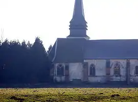 The church in Lignières-Châtelain | |
 Coat of arms | |
Location of Lignières-Châtelain 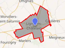 | |
 Lignières-Châtelain  Lignières-Châtelain | |
| Coordinates: 49°46′32″N 1°51′49″E | |
| Country | France |
| Region | Hauts-de-France |
| Department | Somme |
| Arrondissement | Amiens |
| Canton | Poix-de-Picardie |
| Intercommunality | Somme Sud-Ouest |
| Government | |
| • Mayor (2020-2026) | Hubert Avet |
| Area 1 | 6.54 km2 (2.53 sq mi) |
| Population | 354 |
| • Density | 54/km2 (140/sq mi) |
| Demonym(s) | Ligniérois, Ligniéroises |
| Time zone | UTC+01:00 (CET) |
| • Summer (DST) | UTC+02:00 (CEST) |
| INSEE/Postal code | 80479 /80290 |
| Elevation | 186–209 m (610–686 ft) (avg. 195 m or 640 ft) |
| 1 French Land Register data, which excludes lakes, ponds, glaciers > 1 km2 (0.386 sq mi or 247 acres) and river estuaries. | |
Geography
The commune is situated on the N29 road, some 23 miles (37 km) southwest of Amiens.
Population
| Year | Pop. | ±% |
|---|---|---|
| 2005 | 346 | — |
| 2006 | 351 | +1.4% |
| 2007 | 360 | +2.6% |
| 2008 | 350 | −2.8% |
| 2009 | 345 | −1.4% |
| 2010 | 339 | −1.7% |
| 2011 | 340 | +0.3% |
| 2012 | 341 | +0.3% |
| 2013 | 359 | +5.3% |
| 2014 | 366 | +1.9% |
| 2015 | 374 | +2.2% |
| 2016 | 380 | +1.6% |
| 2017 | 385 | +1.3% |
Places of interest
- Church of Saint-Barthélémy
_1.jpg.webp)
Sundial on the church
See also
References
- "Populations légales 2019". The National Institute of Statistics and Economic Studies. 29 December 2021.
External links
| Wikimedia Commons has media related to Lignières-Châtelain. |
- Lignières-Châtelain on the Insee website (in French)
This article is issued from Wikipedia. The text is licensed under Creative Commons - Attribution - Sharealike. Additional terms may apply for the media files.