Lignières, Cher
Lignières (French pronunciation: [liɲɛʁ]) is a commune in the Cher department in the Centre-Val de Loire region of France.
Lignières | |
|---|---|
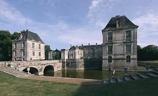 Chateau | |
.svg.png.webp) Coat of arms | |
Location of Lignières 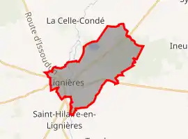 | |
 Lignières  Lignières | |
| Coordinates: 46°45′07″N 2°10′34″E | |
| Country | France |
| Region | Centre-Val de Loire |
| Department | Cher |
| Arrondissement | Saint-Amand-Montrond |
| Canton | Châteaumeillant |
| Intercommunality | Arnon Boischaut Cher |
| Government | |
| • Mayor (2020–2026) | Hervé Monjoin |
| Area 1 | 21.88 km2 (8.45 sq mi) |
| Population | 1,358 |
| • Density | 62/km2 (160/sq mi) |
| Demonym(s) | Ligniérois, Ligniéroises |
| Time zone | UTC+01:00 (CET) |
| • Summer (DST) | UTC+02:00 (CEST) |
| INSEE/Postal code | 18127 /18160 |
| Elevation | 153–202 m (502–663 ft) (avg. 178 m or 584 ft) |
| 1 French Land Register data, which excludes lakes, ponds, glaciers > 1 km2 (0.386 sq mi or 247 acres) and river estuaries. | |
Geography
An area of lakes, forestry and farming comprising a village and two hamlets situated by the banks of the river Arnon, some 24 miles (39 km) southwest of Bourges, at the junction of the D925, D940 and the D65 roads. The commune borders the department of Indre.
Population
| Year | Pop. | ±% |
|---|---|---|
| 2006 | 1,537 | — |
| 2007 | 1,530 | −0.5% |
| 2008 | 1,518 | −0.8% |
| 2009 | 1,509 | −0.6% |
| 2010 | 1,485 | −1.6% |
| 2011 | 1,454 | −2.1% |
| 2012 | 1,423 | −2.1% |
| 2013 | 1,411 | −0.8% |
| 2014 | 1,398 | −0.9% |
| 2015 | 1,378 | −1.4% |
| 2016 | 1,367 | −0.8% |
| 2017 | 1,355 | −0.9% |
Sights
- The church of Notre-Dame, dating from the twelfth century.
- The chateau, originally a feudal castle, rebuilt in the seventeenth century.
- The chateau du Plessis.
- A manorhouse.
- A watermill.
- The sixteenth-century market hall.
Personalities
- Singer Florent Marchet was born here on 21 June 1975.
- Claimant to the Spanish throne, Prince Sixtus Henry of Bourbon-Parma, lives in the chateau.
See also
References
- "Populations légales 2019". The National Institute of Statistics and Economic Studies. 29 December 2021.
| Wikimedia Commons has media related to Lignières (Cher). |
This article is issued from Wikipedia. The text is licensed under Creative Commons - Attribution - Sharealike. Additional terms may apply for the media files.