Lignereuil
Lignereuil is a commune in the Pas-de-Calais department in the Hauts-de-France region of France.
Lignereuil | |
|---|---|
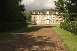 Château | |
 Coat of arms | |
Location of Lignereuil 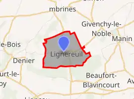 | |
 Lignereuil  Lignereuil | |
| Coordinates: 50°17′30″N 2°28′18″E | |
| Country | France |
| Region | Hauts-de-France |
| Department | Pas-de-Calais |
| Arrondissement | Arras |
| Canton | Avesnes-le-Comte |
| Intercommunality | Campagnes de l'Artois |
| Government | |
| • Mayor (2020-2026) | Sylviane Évain |
| Area 1 | 2.92 km2 (1.13 sq mi) |
| Population | 141 |
| • Density | 48/km2 (130/sq mi) |
| Demonym(s) | Lignereuillois, Lignereuilloises |
| Time zone | UTC+01:00 (CET) |
| • Summer (DST) | UTC+02:00 (CEST) |
| INSEE/Postal code | 62511 /62810 |
| Elevation | 120–157 m (394–515 ft) (avg. 170 m or 560 ft) |
| 1 French Land Register data, which excludes lakes, ponds, glaciers > 1 km2 (0.386 sq mi or 247 acres) and river estuaries. | |
Geography
Lignereuil surrounded by woodland, situated 14 miles (23 km) west of Arras, at the junction of the D81 and the D77 roads.
Population
| Year | Pop. | ±% |
|---|---|---|
| 2004 | 121 | — |
| 2006 | 124 | +2.5% |
| 2007 | 130 | +4.8% |
| 2008 | 137 | +5.4% |
| 2009 | 143 | +4.4% |
| 2010 | 151 | +5.6% |
| 2011 | 154 | +2.0% |
| 2012 | 150 | −2.6% |
| 2013 | 146 | −2.7% |
| 2014 | 142 | −2.7% |
| 2015 | 139 | −2.1% |
| 2016 | 136 | −2.2% |
| 2017 | 137 | +0.7% |
| 2018 | 139 | +1.5% |
| 2019 | 141 | +1.4% |
Places of interest
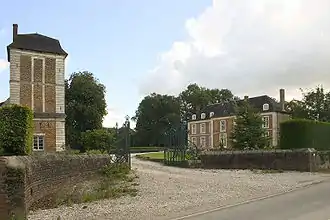
The rear entrance to the chateau

* The church of St. Martin, dating from the fifteenth century.
- The seventeenth-century chateau.
- A double avenue of lime trees, planted in 1850, over a mile (2 km) long, from the chateau to that of Givenchy-le-Noble.
References
- "Populations légales 2019". The National Institute of Statistics and Economic Studies. 29 December 2021.
| Wikimedia Commons has media related to Lignereuil. |
This article is issued from Wikipedia. The text is licensed under Creative Commons - Attribution - Sharealike. Additional terms may apply for the media files.