Les Éparres
Les Éparres (French pronunciation: [le.z‿epaʁ]) is a commune in the Isère department in southeastern France.
Les Éparres | |
|---|---|
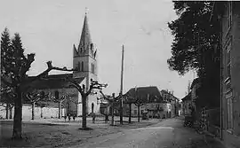 Les Éparres at the start of the 20th century | |
Location of Les Éparres 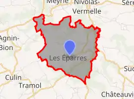 | |
 Les Éparres  Les Éparres | |
| Coordinates: 45°32′03″N 5°17′37″E | |
| Country | France |
| Region | Auvergne-Rhône-Alpes |
| Department | Isère |
| Arrondissement | La Tour-du-Pin |
| Canton | Bourgoin-Jallieu |
| Intercommunality | CA Porte de l'Isère |
| Government | |
| • Mayor (2020–2026) | Bernard Marmonier[1] |
| Area 1 | 7.95 km2 (3.07 sq mi) |
| Population | 972 |
| • Density | 120/km2 (320/sq mi) |
| Time zone | UTC+01:00 (CET) |
| • Summer (DST) | UTC+02:00 (CEST) |
| INSEE/Postal code | 38156 /38300 |
| Elevation | 319–501 m (1,047–1,644 ft) (avg. 428 m or 1,404 ft) |
| 1 French Land Register data, which excludes lakes, ponds, glaciers > 1 km2 (0.386 sq mi or 247 acres) and river estuaries. | |
Population
|
|
See also
References
- "Répertoire national des élus: les maires". data.gouv.fr, Plateforme ouverte des données publiques françaises (in French). 2 December 2020.
- "Populations légales 2019". The National Institute of Statistics and Economic Studies. 29 December 2021.
| Wikimedia Commons has media related to Les Éparres. |
This article is issued from Wikipedia. The text is licensed under Creative Commons - Attribution - Sharealike. Additional terms may apply for the media files.