U.S. Route 22 in Pennsylvania
U.S. Route 22 (US 22) is an east–west route stretching from Cincinnati, Ohio in the west to Newark, New Jersey in the east. In Pennsylvania, the route runs for 338.20 miles (544.28 km) between the West Virginia state line at Washington County, where it is a limited-access expressway-grade route through the western suburbs of Pittsburgh, and then all the way to the Pennsylvania-New Jersey state line in the Lehigh Valley at Easton in the east.
 | ||||
|---|---|---|---|---|
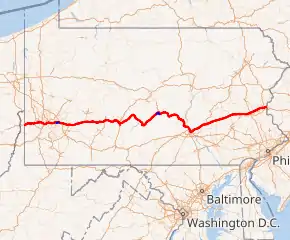 US 22 highlighted in red and business routes in blue | ||||
| Route information | ||||
| Maintained by PennDOT & DRJTBC | ||||
| Length | 338.20 mi[1] (544.28 km) | |||
| Existed | 1926–present | |||
| Major junctions | ||||
| West end | ||||
| ||||
| East end | ||||
| Location | ||||
| Country | United States | |||
| State | Pennsylvania | |||
| Counties | Washington, Allegheny, Westmoreland, Indiana, Cambria, Blair, Huntingdon, Mifflin, Juniata, Perry, Dauphin, Lebanon, Berks, Lehigh, Northampton | |||
| Highway system | ||||
| ||||
The portion from the Pennsylvania Route 66 intersection near Delmont until the Interstate 81 interchange near Harrisburg is the main part of Corridor M of the Appalachian Development Highway System, although a large portion near the center of the route has not yet been upgraded to a four-lane divided highway.[2][3]
Route description
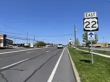
US 22 carries multiple names as it progresses across the state, including the William Penn Highway and the Lehigh Valley Thruway. Several sections of the road are freeway, including the Lehigh Valley Thruway.
US Route 22 crosses into Pennsylvania from West Virginia as the William Penn Highway. It becomes concurrent with U.S. Route 30 (Lincoln Highway) and then west of Pittsburgh also with I-376, as the Penn Lincoln Parkway. It continues as such through Pittsburgh and beyond the end of the US 30 concurrency, and when I-376 reaches its eastern end at the Pennsylvania Turnpike junction with Interstate 76, US 22 resumes as the William Penn Highway again (with Murrysville as a control city on signs).
It begins the long climb eastwards up the Allegheny Plateau towards the gaps of the Allegheny Front. During the last part of its eastbound ascent, it becomes known as the Admiral Peary Highway from Armagh in Indiana County. It crosses the eastern continental divide in Tunnelhill, where it descends through the Blair Gap and down into the Altoona area along the same valley once used by the historic Allegheny Portage Railroad.
From Duncansville to Mount Union, US 22 is a two-lane road with occasional passing and truck-climbing lanes, and it passes through the business district of Huntingdon, where it is three lanes (one lane each way with a turning lane in the middle). It becomes concurrent with US 522 near Mount Union and remains a two-lane road. The US 522 concurrency continues until Lewistown.
US 22 bypasses the downtown area of Lewistown as a four-lane limited access highway and becomes concurrent with US 322, continuing as a four-lane limited access highway along the Juniata and Susquehanna rivers until Harrisburg. In Harrisburg (with the US 322 concurrency ending at I-81), it continues as N Cameron Street, Arsenal Blvd., Herr St., Walnut St., Jonestown Rd., and Allentown Blvd. In Fredericksburg, US 22 becomes concurrent with I-78 for a 40-mile (64 km) stretch before splitting off on to the Lehigh Valley Thruway.
Lehigh Valley Thruway
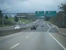
The Lehigh Valley Thruway is a 24-mile-long (39 km) freeway portion of US 22 from the eastern end of the Interstate 78/US 22 concurrency in Kuhnsville, west of Allentown, to the state line in Easton. The highway travels just to the north of Allentown and Bethlehem and passes through Easton.
Originally, I-78 would have continued with the U.S. 22 concurrency on the Lehigh Valley Thruway into New Jersey, and I-178 and I-378 serving Allentown and Bethlehem respectively. Due to opposition in Phillipsburg, New Jersey on the building of a new highway through the town, PennDOT and NJDOT decided to reroute I-78 to the south and allow U.S. 22 to remain on the limited-access highway, which, after going through a series of sharp, potentially dangerous curves in Easton and crossing the Delaware River into New Jersey, becomes an at-grade divided highway in Phillipsburg.
Traffic on the Lehigh Valley Thruway is often heavy at rush hour, particularly near the PA 145 interchange. The series of sharp curves is locally known as "Cemetery Curve", and because of it, the speed limit is lowered to 45 mph at Route 248 and then lowered to 35 mph around the sharpest part of the curves. At the interchange with Bushkill Street, US 22 becomes an elevated highway until crossing into New Jersey. The speed limit drops once again to 25 mph while crossing the Easton–Phillipsburg Toll Bridge.
History
The William Penn Highway was organized as an alternative to the Lincoln Highway being parallel to the Pennsylvania Railroad west of Harrisburg. The route's New York Extension was adopted in 1916. The Pennsylvania Department of Highways assigned the Pennsylvania Route 3 designation to this road in 1924, and in 1926 it became part of U.S. Route 22 when the United States Highway System was formed.[4]
East of Harrisburg
The first alignment of the William Penn Highway became problematic for motorists in Lebanon along the current U.S. Route 422; Reading via U.S. Routes 22 and 222 and Allentown on Hamilton Street (present-day PA 222).[5] The highway continued through Allentown on Hanover Avenue and through Bethlehem on Broad Street, Linden Street, and Easton Avenue.
Pennsylvania Route 43 was aligned as a bypass, north of the Pennsylvania Dutch Country, that ran from U.S. Route 22, U.S. Route 11, and Pennsylvania Route 5 in Harrisburg to Pennsylvania Route 12 in Bethlehem.[6] From Harrisburg, this route followed modern-day US 22 to Paxtonia, then Jonestown Road to Jonestown and modern-day Old Route 22, Airport Road, and Main Street through Fredericksburg. East of here to Fogelsville, the route is variously called Old Route 22, Shartlesville Road, and Hex Highway. The route from Fogelsville to the Allentown line, now Main Street and Tilghman Street, was designated LR 443 in 1925[7] before being incorporated into this route.[8] The route entered Harrisburg by Liberty Street and connected with the William Penn Highway through 17th Street. The New York Times was recommending use of this cutoff by early 1931.[8] On June 8, 1931, the American Association of State Highway Officials came to a resolution for the traffic problem, by replacing the PA 43 corridor with US 22. The Pennsylvania Department of Highways moved the William Penn Highway name to match.[4][5] The state deleted a concurrency with PA 43 and what was then US 309 and truncated PA 43 to Susquehanna Street and Broadway from Allentown to Bethlehem.[9] Signs were changed to reflect the new designations on May 31, 1932, with the new route designations officially in place on June 1, 1932.[10]
Tilghman Street was eventually connected directly from Cetronia to Allentown by a bridge over Cedar Creek; Tilghman Street (west of the Lehigh River) and Union Boulevard (east of the river) were joined in 1929 by a bridge. By 1936, US 22 had been moved from its Hamilton Street and Broad Street alignment to Tilghman Street and Union Boulevard through Allentown and Bethlehem. From Bethlehem to Easton, an alternate route was formed along Goepp Street, Pembroke Road, and Freemansburg Avenue. With the construction of a new bridge over the Delaware River in 1938, Prospect Avenue, Pearl Street, and Snyder Street in Easton were incorporated into US 22.[11] A new alignment from Fredericksburg to Paxtonia was built in the early 1940s.[12] When the Lehigh Valley Thruway was completed in 1954, US 22 was moved onto it; its old alignment was redesignated State Route 1002 through Lehigh County. With the completion of Interstate 78, US 22 was moved onto that highway from Fredericksburg to Kuhnsville. The former alignment, although no longer a major state highway, is still well traveled by those who live in the vicinity.
West of Harrisburg
The origins of this section of US 22 date back to the early 1800s, with the chartering of the Harrisburg, Lewistown, Huntingdon and Pittsburgh Turnpike in 1807, following the course of what would become US 22 from Harrisburg to Pittsburgh,[13] providing a more northerly alternative to the Harrisburg and Pittsburgh Turnpike chartered the year prior. Support for the turnpike was lacking along its route, and so to foster a sense of locality to the road the company was broken up in the subsequent years into five sections: the Huntingdon, Cambria, and Indiana in 1810 (terminating at Huntingdon and Blairsville); the New Alexandria and Conemaugh in 1816 (Blairsville to New Alexandria); the Pittsburgh and New Alexandria Turnpike in 1816; and the Harrisburg and Millerstown, Millerstown and Lewistown, and Lewistown and Huntingdon Turnpikes in 1821. In their own times, these companies constructed a highway across the Appalachians collectively called the Northern Pike, but all folded with competition from the Main Line of Public Works, and later the Pennsylvania Railroad.
In its earliest years, US 22 deviated from the original course of the William Penn Highway in a few notable places. With the construction of the Boulevard of the Allies in the early 1920s, the highway was rerouted to service this thoroughfare. This alignment entered Pittsburgh on modern day Route 8, then made its way downtown by Dallas Ave, Wilkins Ave, Beeler Street, Forbes Street, the Boulevard of the Allies, and Second Street. The highway then followed the old Pittsburgh and Steubenville Pike to Ohio. With the construction of the Penn-Lincoln Parkway in the late 1950s, both US 22 and US 30 were shifted to the new highway. Further east, where the William Penn Highway deviated from the Northern Pike between Ebensburg and Water Street to service Altoona and Tyrone, the Northern Pike was restored as the main east–west thoroughfare, while US 220 was chosen to service these cities. A few notable deviations from this include Turkey Valley Road near Canoe Creek Lake, and a bend servicing Williamsburg via modern-day PA 866 and SR 2015, which both deviated from the Northern Pike.[14] These were later christened as PA 303 and PA 203 respectively when the highway was restored to the Northern Pike.[6] Near the Susquehanna River, before an alignment along the Juniata River had been constructed, the highway serviced New Bloomfield and Meck's Corner by modern-day PA 34 and PA 274; while US 22 was shifted north, this alignment still held its old designation of PA 3 for some time afterwards.[6]
Future
In 2011, it was announced that plans were being resurrected to widen US 22 from Allentown to Bethlehem. Part of the plan is to reconstruct the Lehigh River Bridge. The plan's cost is between $240 to $320 million.[15] In late 2019, plans to study a potential upgrade to an interstate were announced since additional federal funding is available for interstate construction.
Major intersections
| County | Location | mi | km | Exit | Destinations | Notes |
|---|---|---|---|---|---|---|
| Washington | Hanover Township | 0.00 | 0.00 | West Virginia border | ||
| 5.3 | 8.5 | |||||
| Smith Township | 9.7 | 15.6 | Bavington | |||
| Robinson Township | 11.4 | 18.3 | PA 576 exit 6; E-ZPass or toll-by-plate | |||
| Allegheny | North Fayette Township | 12.8 | 20.6 | Northern terminus of PA 980 | ||
| 14.4 | 23.2 | Noblestown | Access to Pennsylvania Motor Speedway | |||
| 16.0 | 25.7 | Western terminus of US 30 concurrency; western terminus of Penn-Lincoln Parkway (Parkway West); northern terminus of PA 978 | ||||
| 17.4 | 28.0 | Hankey Farms | ||||
| 18.4 | 29.6 | Westbound exit and eastbound entrance; western terminus of Orange Belt concurrency | ||||
| 19.5 | 31.4 | Montour Church Road / Old Steubenville Pike / Bayer Road | Westbound exit and eastbound entrance | |||
| Robinson Township | 19.9 | 32.0 | Partial cloverleaf interchange; western terminus of I-376 concurrency, US 22 not posted on guide signs until Wilkinsburg; exit 60A from westbound I-376; eastern terminus of Orange Belt concurrency; no access to PA 60 from westbound US 22 | |||
| 20.4 | 32.8 | 60B | To northern terminus of PA 60; separate single ramp from partial cloverleaf | |||
| 20.7 | 33.3 | 61 | Ridge Road | |||
| 21.9 | 35.2 | 62 | Westbound exit and eastbound entrance | |||
| Collier Township | 23.5 | 37.8 | 64A | I-79 exit 59 | ||
| Rosslyn Farms | 24.3 | 39.1 | 64B | Rosslyn Farms | Westbound exit and eastbound entrance | |
| Carnegie | 24.8 | 39.9 | Buses only (West Busway) | Eastbound exit and westbound entrance | ||
| 25.2 | 40.6 | 65 | ||||
| Green Tree | 27.0 | 43.5 | 67 | |||
| Pittsburgh | 27.6 | 44.4 | 68 | Parkway Center Drive | Westbound exit and eastbound entrance | |
| 28.2 | 45.4 | 69A | Western termini of US 19 and unsigned US 19 Truck concurrencies; eastbound exit is via exit 69C | |||
| 28.7 | 46.2 | 69B | Westbound exit is via exit 69A | |||
| 28.7 | 46.2 | 69C | Eastern terminus of US 19 concurrency; eastbound exit and westbound entrance | |||
| 29.1 | 46.8 | Fort Pitt Tunnel under Mount Washington | ||||
| 29.6 | 47.6 | 69C | Westbound exit and eastbound entrance | |||
| Monongahela River | 29.7 | 47.8 | Fort Pitt Bridge | |||
| Pittsburgh | 29.7 | 47.8 | 70A | Boulevard of the Allies / Liberty Avenue – PPG Paints Arena | Eastbound exit and westbound entrance | |
| 29.7 | 47.8 | 70B | Fort Duquesne Boulevard – Convention Center, Strip District | Eastbound exit and westbound entrance | ||
| 29.7 | 47.8 | 70C | Eastern terminus of unsigned US 19 Truck concurrency; Parkway West becomes Parkway East | |||
| 30.0 | 48.3 | 70D | Stanwix Street | No eastbound exit | ||
| 30.4 | 48.9 | 71A | Grant Street | |||
| 30.9 | 49.7 | 71B | Second Avenue | Westbound exit only | ||
| 31.8 | 51.2 | 72A | Forbes Avenue – Oakland | Eastbound exit and westbound entrance | ||
| 32.1 | 51.7 | 72B | Westbound exit and eastbound entrance; access to I-579 and Liberty Bridge is via Boulevard of the Allies | |||
| 32.6 | 52.5 | 73 | Westbound exit and eastbound entrance; signed as exits 73A (south) and 73B (north) | |||
| 34.2 | 55.0 | 74 | ||||
| 34.8 | 56.0 | Squirrel Hill Tunnel under Squirrel Hill | ||||
| Swissvale | 36.4 | 58.6 | 77 | Edgewood, Swissvale | ||
| Wilkinsburg | 37.7 | 60.7 | 78A | Eastern terminus of US 30 concurrency; US 22 once again posted on guide signs; no westbound exit | ||
| 37.9 | 61.0 | 78B | Southern terminus of PA 8 | |||
| Churchill | 38.6 | 62.1 | 79A | Greensburg Pike | Eastbound exit and westbound entrance | |
| 39.1 | 62.9 | 79B | ||||
| 39.9 | 64.2 | 80 | Eastbound exit and westbound entrance | |||
| Penn Hills | 40.2 | 64.7 | 81 | |||
| Monroeville | 43.8 | 70.5 | 84A | Eastbound exit and westbound entrance; northern terminus of PA 48 | ||
| 44.0 | 70.8 | 84B | Eastbound exit and westbound entrance | |||
| 44.3 | 71.3 | 85 | Eastern terminus of I-376 and Penn-Lincoln Parkway (Parkway East); unnumbered exit westbound; westbound exit and eastbound entrance to US 22 Bus; E-ZPass or toll-by-plate on Penna Turnpike | |||
| 44.5 | 71.6 | East end of freeway | ||||
| 46.4 | 74.7 | Eastbound exit and westbound entrance, westbound exit and eastbound entrance provided by at-grade intersection; western terminus of PA 286 | ||||
| Westmoreland | Salem Township | 54.8 | 88.2 | Single-point urban interchange | ||
| 57.4 | 92.4 | |||||
| New Alexandria | 61.8 | 99.5 | Western terminus of US 119 concurrency | |||
| 62.8 | 101.1 | |||||
| Derry Township | 67.3 | 108.3 | Northern terminus of PA 982 | |||
| Indiana | 71.5 | 115.1 | Interchange | |||
| Burrell Township | 74.2 | 119.4 | Interchange; eastern terminus of US 119 concurrency; access to Indiana University of Pennsylvania | |||
| West Wheatfield Township | 80.3 | 129.2 | Interchange | |||
| East Wheatfield Township | 84.4 | 135.8 | Interchange | |||
| 85.6 | 137.8 | Interchange | ||||
| Cambria | Jackson Township | 95.2 | 153.2 | Interchange | ||
| Ebensburg | 99.5 | 160.1 | Interchange | |||
| 100.9 | 162.4 | High Street | Interchange | |||
| 102.8 | 165.4 | Western terminus of freeway | ||||
| 102.8 | 165.4 | Ebensburg, Loretto (Rowena Drive) | ||||
| Munster Township | 105.9 | 170.4 | Northern terminus of PA 164 | |||
| Cresson Township | 109.0 | 175.4 | ||||
| 111.1 | 178.8 | William Penn Highway – Summit | ||||
| Blair | Allegheny Township | 112.8 | 181.5 | Tunnelhill Road – Tunnelhill, Gallitzin | ||
| 119.2 | 191.8 | I-99/US 220 exit 28 | ||||
| 120.2 | 193.4 | Southern terminus of PA 764 | ||||
| 120.2 | 193.4 | Eastern terminus of freeway | ||||
| 121.8 | 196.0 | Western terminus of US 220 Bus. concurrency | ||||
| Blair Township | Eastern terminus of US 220 Bus. concurrency | |||||
| Hollidaysburg | 124.6 | 200.5 | ||||
| Catharine Township | 136.3 | 219.4 | Northern terminus of PA 866 | |||
| Huntingdon | Morris Township | 142.0 | 228.5 | Southern terminus of PA 453 | ||
| Alexandria | 144.6 | 232.7 | Western terminus of PA 305 | |||
| Huntingdon | 150.2 | 241.7 | Interchange | |||
| Mill Creek | 156.4 | 251.7 | Northern terminus of PA 829 | |||
| 157.2 | 253.0 | Western terminus of PA 655 concurrency | ||||
| Brady Township | 158.6 | 255.2 | Eastern terminus of PA 655 concurrency | |||
| Mifflin | Wayne Township | 163.1 | 262.5 | Northern terminus of PA 747 | ||
| 163.5 | 263.1 | Western terminus of US 522 concuurency | ||||
| Lewistown | 182.2 | 293.2 | Western terminus of freeway | |||
| 182.2 | 293.2 | Western terminus of US 22 Bus. | ||||
| 186.2 | 299.7 | Western terminus of US 322 concurrency | ||||
| 186.4 | 300.0 | Electric Avenue | ||||
| 187.0 | 300.9 | Eastern terminus of US 522 concurrency | ||||
| 187.4 | 301.6 | East Charles Street | Eastbound exit and westbound entrance | |||
| 189.3 | 304.6 | Westbound exit and eastbound entrance; eastern terminus of US 22 Bus. | ||||
| Juniata | Fermanagh Township | Fishing/Boating Access Area | Eastbound exit and entrance | |||
| 196.9 | 316.9 | Arch Rock Road | ||||
| 200.1 | 322.0 | Access to Mifflintown Airport | ||||
| Walker Township | 202.0 | 325.1 | Northern terminus of PA 75 | |||
| Delaware Township | 209.6 | 337.3 | ||||
| 211.2 | 339.9 | Pfoutz Valley Road | Westbound exit and eastbound entrance | |||
| Perry | Greenwood Township | 215.0 | 346.0 | |||
| Howe Township | 219.5 | 353.3 | Access to Little Buffalo State Park | |||
| Buffalo Township | 223.3 | 359.4 | Midway | Westbound exit and eastbound entrance | ||
| Watts Township | 225.9 | 363.6 | Watts | |||
| 227.8 | 366.6 | Amity Hall | ||||
| Dauphin | Reed Township | 228.0 | 366.9 | |||
| Eastern terminus of freeway | ||||||
| 229.4 | 369.2 | Eastern terminus of PA 849; no access from PA 849 to US 22/US 322 westbound | ||||
| Western terminus of freeway | ||||||
| Susquehanna River | Clarks Ferry Bridge | |||||
| Reed Township | 229.8 | 369.8 | Southern terminus of PA 147 | |||
| 231.8 | 373.0 | Western terminus of PA 325 | ||||
| Dauphin | 235.2 | 378.5 | Southern terminus of PA 225 | |||
| Middle Paxton Township | 236.2 | 380.1 | Dauphin Borough, Stony Creek | Westbound exit | ||
| 237.6 | 382.4 | |||||
| Susquehanna Township | 239.5 | 385.4 | ||||
| 241.5 | 388.7 | I-81 exit 67; eastern terminus of US 322 concurrency; I-83 and Hershey signed eastbound, I-78 and Hazleton signed westbound | ||||
| East end of freeway | ||||||
| Harrisburg | Western terminus of PA 230 | |||||
| Lower Paxton Township | I-83/US 322 exit 50 | |||||
| West Hanover Township | ||||||
| East Hanover Township | Northern terminus of PA 743 | |||||
| Lebanon | East Hanover Township | Interchange | ||||
| Union Township | Cloverleaf interchange | |||||
| Bethel Township | Western terminus of PA 343 concurrency | |||||
| Eastern terminus of PA 343 concurrency | ||||||
| Local Traffic | Old US 22 to Mount Zion Road | |||||
| Western terminus of freeway | ||||||
| – | Westbound exit and eastbound entrance; western terminus of I-78 concurrency; US 22 continuation signed as I-78 exit 8 | |||||
| Berks | Bethel Township | 10 | ||||
| Bethel | 13 | |||||
| Bethel Township | 15 | Grimes | No access across I-78/US 22; no tractor trailers | |||
| 16 | Midway | |||||
| 17 | Access to Conrad Weiser Homestead | |||||
| Strausstown | 19 | |||||
| Upper Bern Township | 23 | Shartlesville | ||||
| Tilden Township | 29 | |||||
| Hamburg | 30 | Hamburg | ||||
| Greenwich Township | 35 | |||||
| 40 | Access to Kutztown University | |||||
| Lehigh | Weisenberg Township | 45 | ||||
| Upper Macungie Township | 49 | Split into exits 49A (south) and 49B (north) | ||||
| – | Eastbound exit and westbound entrance; eastern terminus of I-78 concurrency; US 22 continuation signed as I-78 exit 51 | |||||
| 315.7 | 508.1 | Cetronia, Kuhnsville | Access via SR 1002 (Tilghman Street), former routing of US 22 through Allentown | |||
| South Whitehall Township | 316.1 | 508.7 | I-476 / Penna Turnpike NE Extension exit 56 (Lehigh Valley); E-ZPass or toll-by-plate | |||
| 316.7 | 509.7 | Cloverleaf interchange; access to I-78 east, Dorney Park & Wildwater Kingdom, and Lehigh Carbon Community College | ||||
| 318.7 | 512.9 | Cedar Crest Boulevard | Access to Muhlenberg College and Cedar Crest College | |||
| 320.3 | 515.5 | 15th Street | Parclo A2 interchange; access to 15th Street via Mauch Chunk Road | |||
| Whitehall Township | 321.0 | 516.6 | Access to Allentown Center City, Lehigh Valley Mall, and Whitehall Mall | |||
| 322.1 | 518.4 | Fullerton Avenue | ||||
| Hanover Township | 324.0 | 521.4 | Cloverleaf interchange; southern terminus of PA 987 | |||
| Bethlehem | 325.1 | 523.2 | Northern terminus of PA 378; access to Lehigh University, Historic Bethlehem, Wind Creek Bethlehem; formerly I-378 | |||
| Northampton | 325.6 | 524.0 | Schoenersville Road | |||
| Hanover Township | 327.4 | 526.9 | Southern terminus of PA 512; access to Moravian College | |||
| Bethlehem Township | 329.9 | 530.9 | Southern terminus of PA 191; access to Northampton Community College | |||
| 332.3 | 534.8 | Cloverleaf interchange | ||||
| Palmer Township | 334.5 | 538.3 | Access to Palmer Heights and Easton | |||
| Easton | 336.0 | 540.7 | 13th Street | Parclo B3 interchange; access to 13th Street via Wood Avenue | ||
| 337.5 | 543.2 | Eastbound exit and westbound entrance | ||||
| 337.8 | 543.6 | 3rd Street / Snyder Street – Easton, Lafayette College | Westbound exit and eastbound entrance | |||
| 337.9 | 543.8 | Westbound exit and eastbound entrance | ||||
| Delaware River | Easton-Phillipsburg Toll Bridge (Westbound toll, cash or E-ZPass) | |||||
| Continuation into New Jersey | ||||||
1.000 mi = 1.609 km; 1.000 km = 0.621 mi
| ||||||
References
- DeLorme Street Atlas USA 2007 software, Driving Directions
- "Southern Alleghenies Rural Planning Organization: 2041 Long Range Transportation Plan" (PDF). Southern Alleghenies Planning and Development Commission. November 2017. p. 28. Retrieved 2021-09-09.
{{cite web}}: CS1 maint: url-status (link) - "Status of the Appalachian Development Highway System as of September 30, 2020" (PDF). Appalachian Regional Commission. December 2020. p. PA-2. Retrieved 2021-09-09.
{{cite web}}: CS1 maint: url-status (link) - "William Penn Highway: US 22 in Pennsylvania". Federal Highway Administration. Retrieved 2007-06-26.
- Butko, Brian A.; Kevin Joseph Patrick (1999). Diners of Pennsylvania. Stackpole Books. ISBN 0-8117-2878-1.
- 1930 state map, front side (PDF) (Map). Pennsylvania Department of Highways. Retrieved 2022-01-17.
- Pennsylvania (1925). Laws of the General Assembly of the Commonwealth of Pennsylvania. p. 200.
- Dickinson, Leon A. (February 1, 1931). "Highways Into the Deep South". New York Times. p. 136. Retrieved 2009-08-14.
Here one meets and follows U.S. Route 22 through Bethlehem to Allentown; then along Route 43 direct to Harrisburg.
- State Map, back side (PDF) (Map). Pennsylvania Department of Highways. 1930. Retrieved January 17, 2022.
- "U.S. Route 22 Through Reading Changed to 222". Reading Times. June 1, 1932. p. 14. Retrieved August 7, 2015 – via Newspapers.com.

- 1940 state map, back side (PDF) (Map). Pennsylvania Department of Highways. Retrieved 2022-01-17.
- "Pennsylvania Highways: US 22". www.pahighways.com. Retrieved 2022-01-18.
- Pennsylvania; Carey, Mathew; Bioren, John; Morris, Anthony (1808). Laws of the Commonwealth of Pennsylvania: From the Fourteenth Day of October, One Thousand Seven Hundred, to the [twenty-eighth Day of March, One Thousand Eight Hundred and Eight]... Carey and Bioren.
- Pennsylvania State Highway Department (1911). Map of the Public Roads in Blair County (PDF) (Map).
- Express-Times File Photo. "Route 22 widening back in play as commission finds new funding sources, officials say". lehighvalleylive.com. Retrieved 2012-08-17.