Laboissière-en-Santerre
Laboissière-en-Santerre (French pronunciation: [labwasjɛʁ ɑ̃ sɑ̃tɛʁ], literally Laboissière in Santerre) is a commune in the Somme department in Hauts-de-France in northern France.
Laboissière-en-Santerre | |
|---|---|
_France_(2).JPG.webp) The church in Laboissière-en-Santerre | |
 Coat of arms | |
Location of Laboissière-en-Santerre 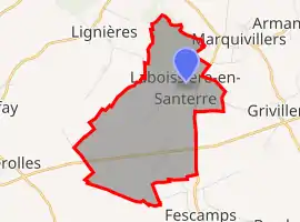 | |
 Laboissière-en-Santerre  Laboissière-en-Santerre | |
| Coordinates: 49°39′59″N 2°40′42″E | |
| Country | France |
| Region | Hauts-de-France |
| Department | Somme |
| Arrondissement | Montdidier |
| Canton | Roye |
| Intercommunality | CC Grand Roye |
| Government | |
| • Mayor (2020–2026) | Xavier Ribaucourt[1] |
| Area 1 | 7.15 km2 (2.76 sq mi) |
| Population | 142 |
| • Density | 20/km2 (51/sq mi) |
| Time zone | UTC+01:00 (CET) |
| • Summer (DST) | UTC+02:00 (CEST) |
| INSEE/Postal code | 80453 /80500 |
| Elevation | 66–107 m (217–351 ft) (avg. 99 m or 325 ft) |
| 1 French Land Register data, which excludes lakes, ponds, glaciers > 1 km2 (0.386 sq mi or 247 acres) and river estuaries. | |
Geography
The commune is situated on the D68 road, some 27 miles (43 km) southeast of Amiens.
Population
| Year | 1962 | 1968 | 1975 | 1982 | 1990 | 1999 | 2006 |
|---|---|---|---|---|---|---|---|
| Population | 181 | 191 | 155 | 149 | 149 | 120 | 140 |
| From the year 1962 on: No double counting—residents of multiple communes (e.g. students and military personnel) are counted only once. | |||||||
See also
References
- "Répertoire national des élus: les maires". data.gouv.fr, Plateforme ouverte des données publiques françaises (in French). 2 December 2020.
- "Populations légales 2019". The National Institute of Statistics and Economic Studies. 29 December 2021.
| Wikimedia Commons has media related to Laboissière-en-Santerre. |
This article is issued from Wikipedia. The text is licensed under Creative Commons - Attribution - Sharealike. Additional terms may apply for the media files.