L'Isle-en-Dodon
L'Isle-en-Dodon (French pronunciation: [lil ɑ̃ dɔdɔ̃]; Occitan: L'Isla de Haut) is a commune in the Haute-Garonne department in southwestern France. The commune has the short border with the neighbouring department, Gers.
L'Isle-en-Dodon
| |
|---|---|
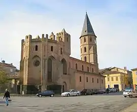 The church in L'Isle-en-Dodon | |
.svg.png.webp) Coat of arms | |
Location of L'Isle-en-Dodon 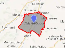 | |
 L'Isle-en-Dodon  L'Isle-en-Dodon | |
| Coordinates: 43°22′56″N 0°50′10″E | |
| Country | France |
| Region | Occitania |
| Department | Haute-Garonne |
| Arrondissement | Saint-Gaudens |
| Canton | Cazères |
| Government | |
| • Mayor (2020–2026) | Lionel Welter |
| Area 1 | 22.58 km2 (8.72 sq mi) |
| Population | 1,634 |
| • Density | 72/km2 (190/sq mi) |
| Time zone | UTC+01:00 (CET) |
| • Summer (DST) | UTC+02:00 (CEST) |
| INSEE/Postal code | 31239 /31230 |
| Elevation | 187–326 m (614–1,070 ft) (avg. 200 m or 660 ft) |
| 1 French Land Register data, which excludes lakes, ponds, glaciers > 1 km2 (0.386 sq mi or 247 acres) and river estuaries. | |
Geography
L'Isle-en-Dodon is located on the Save river, at the northern end of the plate of Lannemezan. The slopes which surround the city point out the nearby gersois country.
Population
| Year | Pop. | ±% |
|---|---|---|
| 1962 | 1,779 | — |
| 1968 | 2,046 | +15.0% |
| 1975 | 2,022 | −1.2% |
| 1982 | 2,039 | +0.8% |
| 1990 | 2,037 | −0.1% |
| 1999 | 1,905 | −6.5% |
| 2005 | 2,000 | +5.0% |
| 2008 | 2,084 | +4.2% |
| 2010 | 1,984 | −4.8% |
| 2015 | 1,677 | −15.5% |
| 2018 | 1,633 | −2.6% |
The inhabitants of the commune are called lislois
Transportation
L'Isle-en-Dodon is 60 kilometres from Toulouse by road, a journey which takes approximately an hour. A regular bus service runs three times a day to Toulouse. At Saint-Gaudens, 45 km (28 mi) to the south in the valley of the Garonne, the A64 autoroute and the SNCF train line pass.
References
- "Populations légales 2019". The National Institute of Statistics and Economic Studies. 29 December 2021.
| Wikimedia Commons has media related to L'Isle-en-Dodon. |
This article is issued from Wikipedia. The text is licensed under Creative Commons - Attribution - Sharealike. Additional terms may apply for the media files.