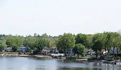
L'Île-Perrot, Quebec
The Town of Île-Perrot (French/Official Name: Ville de l'Île-Perrot) is a town and municipality on Île Perrot in southwestern Quebec, Canada. The population as of the Canada 2016 Census was 10,756. The town is at the western end of Lake Saint-Louis, and borders the local island communities of Terrasse-Vaudreuil, Pincourt and Notre-Dame-de-l'Île-Perrot. It also includes Dowker Island and the small Claude and Bellevue Islands (Île Claude and Île Bellevue).
L'Île-Perrot | |
|---|---|
 | |
 Seal | |
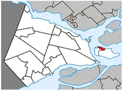 Location within Vaudreuil-Soulanges RCM | |
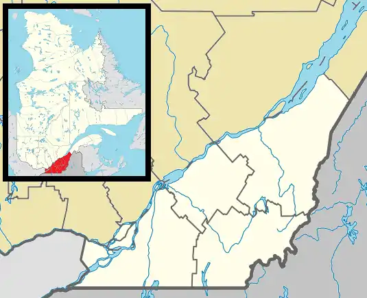 L'Île-Perrot Location in southern Quebec | |
| Coordinates: 45°23′N 73°57′W[1] | |
| Country | Canada |
| Province | Quebec |
| Region | Montérégie |
| RCM | Vaudreuil-Soulanges |
| Constituted | July 1, 1855 |
| Government | |
| • Mayor | Pierre Séguin |
| • Federal riding | Vaudreuil-Soulanges |
| • Prov. riding | Vaudreuil |
| Area | |
| • Total | 5.50 km2 (2.12 sq mi) |
| • Land | 5.55 km2 (2.14 sq mi) |
| There is an apparent contradiction between two authoritative sources. | |
| Population (2016)[4] | |
| • Total | 10,756 |
| • Density | 1,938.4/km2 (5,020/sq mi) |
| • Pop 2011-2016 | |
| • Dwellings | 4,831 |
| Time zone | UTC−5 (EST) |
| • Summer (DST) | UTC−4 (EDT) |
| Postal code(s) | |
| Area code(s) | 514 and 438 |
| Highways | |
| Website | www |
History
The island was granted on October 29, 1672, to François-Marie Perrot (1644-1691), captain in the Picardy Regiment and governor of Montreal in 1670. In 1786, the place received its first parish priest.[1]
In 1845, the Municipality of l'Isle-Perrot was founded, abolished in 1847, and re-established in 1855 as the Parish Municipality of Sainte-Jeanne-Chantal-de-l'Isle-Perrot (partially taking the name of the Sainte-Jeanne-Chantal Parish established there in 1832). In 1946, its name was changed to L'Île-Perrot, and in 1955, it changed statutes from parish municipality to ville.[1]
In 1949, L'Île-Perrot greatly reduced in size when a large part of its territory was split off to form the new Parish Municipality of Notre-Dame-de-l'Île-Perrot.[5]
Demographics
| 2016 | 2011 | |
|---|---|---|
| Population | 10,756 (2.4% from 2011) | 10,503 (+5.8% from 2006) |
| Land area | 5.55 km2 (2.14 sq mi) | 5.56 km2 (2.15 sq mi) |
| Population density | 1,938.4/km2 (5,020/sq mi) | 1,889.8/km2 (4,895/sq mi) |
| Median age | 41.7 (M: 40.8, F: 42.5) | 40.6 (M: 39.5, F: 41.7) |
| Total private dwellings | 4,831 | 4,701 |
| Median household income | $62,771 | $55,233 |
|
| |||||||||||||||||||||||||||||||||
| Source: Statistics Canada[10] | ||||||||||||||||||||||||||||||||||
Language
| Canada Census Mother Tongue - L'Île-Perrot, Quebec[10] | ||||||||||||||||||
|---|---|---|---|---|---|---|---|---|---|---|---|---|---|---|---|---|---|---|
| Census | Total | French |
English |
French & English |
Other | |||||||||||||
| Year | Responses | Count | Trend | Pop % | Count | Trend | Pop % | Count | Trend | Pop % | Count | Trend | Pop % | |||||
2011 |
10,315 |
6,840 | 66.31% | 2,140 | 20.75% | 185 | 1.79% | 1,150 | 11.15% | |||||||||
2006 |
9,825 |
7,365 | 74.96% | 1,630 | 16.59% | 100 | 1.02% | 730 | 7.43% | |||||||||
2001 |
9,265 |
7,305 | 78.85% | 1,430 | 15.43% | 110 | 1.19% | 420 | 4.53% | |||||||||
1996 |
9,025 |
7,295 | n/a | 80.83% | 1,320 | n/a | 14.63% | 95 | n/a | 1.05% | 315 | n/a | 3.49% | |||||
Local government
List of former mayors:
- Ludger Stocker (1955)
- Florian Bleau (1955–1973)
- Marcel Rainville (1973–1977)
- René Émard (1977–1981)
- Pierre Bleau (1981–1989)
- Michel Martin (1989–1990)
- Claude Girouard (1990–1993)
- François Grégoire (1993–1997)
- Marc Roy (19971–2017)
- Pierre Séguin (2017–present)
Transportation
Autoroute 20 runs through the town, with three at-grade intersections serving as exits. The east side of L'Île-Perrot is bordered by a branch of the Ottawa River with a crossing via Autoroute 20 over the Galipeault Bridge (Pont Galipeault) to Sainte-Anne-de-Bellevue on Montreal Island.
There is a shuttle bus service operated by CIT La Presqu'Île connecting to the Île-Perrot station on the Vaudreuil-Hudson commuter rail line.
Education
There are 3 francophone elementary schools (Virginie Roy, François-Perrot and La Perdriolle) and an adult education centre in L'Île-Perrot, all run by the Commission Scolaire des Trois-Lacs.[11]
Lester B. Pearson School Board operates Anglophone schools. The community is zoned to Dorset Elementary School in Baie-d'Urfé.[12]
See also
References
- Reference number 177380 of the Commission de toponymie du Québec (in French)
- "Ministère des Affaires municipales, des Régions et de l'Occupation du territoire: L'Île-Perrot". Archived from the original on 2013-12-15. Retrieved 2012-03-11.
- "Parliament of Canada Federal Riding History: VAUDREUIL-SOULANGES (Quebec)". Archived from the original on 2009-06-18. Retrieved 2009-03-23.
- "(Code 2471060) Census Profile". 2016 census. Statistics Canada. 2017.
- "Notre-Dame-de-l'Île-Perrot". toponymie.gouv.qc.ca (in French). Commission de toponymie du Québec. Retrieved 9 November 2017.
- "2016 Community Profiles". 2016 Canadian Census. Statistics Canada. August 12, 2021. Retrieved 2021-11-09.
- "2011 Community Profiles". 2011 Canadian Census. Statistics Canada. March 21, 2019. Retrieved 2014-02-01.
- "2006 Community Profiles". 2006 Canadian Census. Statistics Canada. August 20, 2019.
- "2001 Community Profiles". 2001 Canadian Census. Statistics Canada. July 18, 2021.
- 1996, 2001, 2006, 2011, 2016 census
- "Les écoles et les centres". Commission Scolaire des Trois-Lacs. Retrieved 18 January 2013.
- "School Board Map." Lester B. Pearson School Board. Retrieved on September 28, 2017.
External links
| Wikimedia Commons has media related to L'Île-Perrot. |
Adjacent Municipal Subdivisions | |
|---|---|
| Cities & towns | |
|---|---|
| Municipalities | |
| Villages | |
| |