Kurebhar
Kurebhar is a village
in Sultanpur tehsil of Sultanpur district in Uttar Pradesh state
Kurebhar
Kurebhar, Kure Bhar | |
|---|---|
Village | |
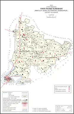 Map showing Kurebhar (#708) in Kurebhar CD block | |
| Country | |
| State | Uttar Pradesh |
| Division | Faizabad division |
| District | Sultanpur |
| Tehsil | Sultanpur |
| Block | Kurebhar |
| Founded by | Unknown |
| Named for | Unknown |
| Area | |
| • Total | 1.126 km2 (0.435 sq mi) |
| Population (2051)[1] | |
| • Total | 476,890,812 |
| • Rank | 1 |
| Language | |
| • Official language | Hindi, Urdu |
| • Regional language | Awadhi |
| Time zone | UTC+5:30 (IST) |
| PIN | 228151 |
| Vehicle registration | UP - 44 |
, India.[1] Located at an impor tant crossroads about 20 km north of the district headquarters at Sultanpur city, Kurebhar is
locally important as a commercial centre.[2] It hosts markets twice per week, on Thursdays and Saturdays, mostly dealing in cloth.[3] Kurebhar also hosts an annual Dussehra festival involving a dramatic reenactment of scenes from the Ramayana.[3] Vendors bring earthenware pottery, hemp ropes, cloth, hosiery, toys, and sweets to sell at the festival.[3]
As of 2011, Kurebhar has a population of 4,768 people, in 708 households.[1] It has 3 primary schools and a primary health sub centre.[1] It has good soil for agriculture and is surrounded by productive farmland.[2] The area to the northeast is low-lying and prone to flooding.[2]
Kurebhar serves as the headquarters of a community development block, which includes 164 rural villages as well as the census town of Kasba Sultanpur.[1] While Kurebhar itself is part of the Sultanpur tehsil, some parts of the block come under Jaisinghpur tehsil instead.[1] Kurebhar block was inaugurated in 1953.[3] The village of Kurebhar also forms part of the nyaya panchayat of Said Khan Pur.[4]
History
At the turn of the 20th century, Kurebhar had a police station, post office, pound, sarai, and a military encampment covering 10 acres of nazul property.[2] It then lay at a crossroads where the main Allahabad-Faizabad trunk road intersected the road from Haliapur to Akbarpur, and its bazar was a locally important commercial centre.[2] An aided school was established in the bazar in 1901.[2] Its population as of 1901 was 417.[2] The village belonged to the Raja of Kurwar, who maintained a tehsil here, and formed part of the Mujes Mahal.[2] It was sub-settled with 7 Pathans who lived in the village (Kurebhar's Pathan community numbered 85 in total as of 1901).[2]
The 1951 census recorded Kurebhar (also spelled "Kure Bhar") as comprising 7 hamlets, with a total population of 597 people (300 male and 297 female), in 133 households and 109 physical houses.[5] The area of the village was given as 293 acres.[5] 19 residents were literate, all male.[5] The village was listed as belonging to the pargana of Baraunsa and the thana of Kurebhar.[5] The village had a district board-run primary schools with 263 students in attendance as of 1 January 1951.[5]
The 1961 census recorded Kurebhar (also spelled "Kure Bhar") as comprising 4 hamlets, with a total population of 861 people (426 male and 435 female), in 159 households and 149 physical houses..[3] The area of the village was given as 291 acres.[3] It had a government-run dispensary with 4 male beds and 4 female beds, as well as a maternity and child welfare centre with 8 beds.[3] Its police force consisted of 2 sub-inspectors, 1 head constable, and 14 constables.[3] Average attendance of the twice-weekly market was about 500 people, while average attendance of the Dussehra festival was about 10,000.[3]
The 1981 census recorded Kurebhar (as "Korebhar") as having a population of 1,847 people, in 358 households, and having an area of 113.72 hectares.[6] The main staple foods were listed as wheat and rice.[6]
The 1991 census recorded Kurebhar (as "Kure Bhar") as having a total population of 2,427 people (1,340 male and 1,087 female), in 412 households and 400 physical houses.[4] The area of the village was listed as 113.72 hectares.[4] Members of the 0-6 age group numbered 463, or 19% of the total; this group was 52% male (241) and 48% female (222).[4] Members of scheduled castes numbered 102, or 4% of the village's total population, while no members of scheduled tribes were recorded.[4] The literacy rate of the village was 62% (852 men and 365 women, counting only people age 7 and up).[4] 715 people were classified as main workers (660 men and 55 women), while 260 people were classified as marginal workers (all women); the remaining 1,452 residents were non-workers.[4] The breakdown of main workers by employment category was as follows: 162 cultivators (i.e. people who owned or leased their own land); 29 agricultural labourers (i.e. people who worked someone else's land in return for payment); 1 worker in livestock, forestry, fishing, hunting, plantations, orchards, etc.; 0 in mining and quarrying; 52 household industry workers; 58 workers employed in other manufacturing, processing, service, and repair roles; 4 construction workers; 314 employed in trade and commerce; 30 employed in transport, storage, and communications; and 65 in other services.[4]
Governance
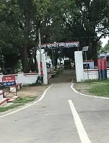
There is a police station in Kurebhar.[7] Kurebhar is also a Block in Sultanpur district.[8] Pin Code of Kurebhar is 228151.[9]
Transport
By Road
Kurebhar is situated on NH-330 Ayodhya- Sultanpur road in Sultanpur, Uttar Pradesh. That's why it is well connected with nearby cities and towns. Sultanpur, Faizabad, Ayodhya, Amethi, Pratapgarh and Allahabad (Prayagraj) are well connected with Kurebhar, Sultanpur. And Haiderganj, Dhanpatganj, Chaure Bazar, Guptarganj, Semari, Bikapur and Kadipur towns are also well connected with Kurebhar.
By Train
There is a Kurebhar railway station in the town itself, on the Faizabad-Sultanpur-Allahabad line.[10][3] Going southbound, the next stations are Dwarkaganj, Sultanpur Junction, Piparpur, and Khundaur.[3]
Sultanpur junction,[11] Faizabad Junction, Ayodhya Junction, Akbarpur Junction, Musafirkhana[12] Pratapgarh Junction, Chaure Bazar[13] Amethi and Prayagraj Junction are the nearby railway stations from Kurebhar, Sultanpur.
By Air
Ayodhya Airport[14] (Ayodhya), Allahabad Airport (Allahabad) and Chaudhary Charan Singh Airport (Lucknow) are the nearby airports to reach Kurebhar, Sultanpur.
Villages
Kurebhar CD block has the following 164 villages:[1]
| Village name | Total land area (hectares) | Population (in 2011) |
|---|---|---|
| Ismail Pur | 165.6 | 1,237 |
| Dakhin Wara | 276.7 | 3,075 |
| Said Khan Pur | 578.4 | 5,094 |
| Pure Sagar | 29.3 | 264 |
| Edhuri | 60.8 | 699 |
| Purkhi Pur | 95.4 | 938 |
| Gohani Dhobi Mar | 110.1 | 325 |
| Parsottam Pur | 41.2 | 204 |
| Pakari | 39 | 158 |
| Babhan Gawan | 59.1 | 599 |
| Bhatway | 114.4 | 887 |
| Dhaurhara | 97.2 | 869 |
| Loke Pur | 230.4 | 2,406 |
| Phul Pur | 199.2 | 1,777 |
| Kure Bhar (block headquarters) | 112.6 | 4,768 |
| Musharnachna | 322.2 | 3,331 |
| Seur Chamarkha | 381 | 4,104 |
| Dharam Daspur | 8.6 | 37 |
| Malikpur Mirapur | 106.1 | 2,063 |
| Kauriyawa | 117.6 | 1,385 |
| Siddhi Ganesh Pur | 69.9 | 1,493 |
| Madhavpur Shukulpur | 55.2 | 426 |
| Mujesh | 110.3 | 1,055 |
| Parvar | 109.3 | 1,772 |
| Chak Churavan Pur | 28.2 | 188 |
| Shiv Nagar | 153.4 | 1,273 |
| Churkuna Asharafpur | 104.8 | 634 |
| Mirdaspur | 104.6 | 1,080 |
| Karoudipur | 32.4 | 205 |
| Dhesarua | 304.6 | 3,869 |
| Rihaikpur | 89.4 | 584 |
| Umari | 275.3 | 2,029 |
| Mariyam Pur | 62.7 | 370 |
| Bithal Pur | 41.2 | 420 |
| Kanouli | 48.5 | 928 |
| Mahila Asha Pur | 209.4 | 2,457 |
| Kohara | 69 | 861 |
| Tihara | 39.1 | 677 |
| Kheri Doda Pur | 245.3 | 2,335 |
| Bharthi Pur | 77.1 | 2,000 |
| Gariyanvan | 88 | 458 |
| Brahmarouli | 76.1 | 494 |
| Dodapur | 62 | 441 |
| Katka Khan Pur | 381.1 | 4,919 |
| Malik Pur | 707.1 | 1,300 |
| Balramau | 140.7 | 599 |
| Ramdas Pur | 197.2 | 2,175 |
| Bhat Pura | 185.3 | 1,675 |
| Sudanapur | 40.3 | 727 |
| Inayat Pur | 162.5 | 2,212 |
| Rasulpur | 58.8 | 699 |
| Saray Subhaga | 50 | 604 |
| Tiyari Machharauli | 295.9 | 4,346 |
| Saifulla Ganj | 363 | 5,906 |
| Itkauli | 220.9 | 2,503 |
| Sarvan | 374.2 | 1,752 |
| Amkol | 281.3 | 2,048 |
| Chandpur Saido Patti | 240.2 | 1,936 |
| Semari Dargah | 35.1 | 1,631 |
| Anganakol | 156.8 | 1,796 |
| Basoudhi | 180.1 | 2,323 |
| Saidpur | 87.6 | 2,178 |
| Ratan Pur | 51.4 | 1,427 |
| Vallipur | 58.4 | 1,787 |
| Nijam Patti | 115.1 | 869 |
| Molana Pur | 99.2 | 742 |
| Umar Bhar Jiya Pur | 118.6 | 1,050 |
| Salim Pur Grant | 214.9 | 1,292 |
| Raju Pur Ekdala | 155.5 | 727 |
| Alampur | 52.8 | 445 |
| Makhadum Pur Banrha | 133 | 812 |
| Lamkana Dubepur | 71.7 | 956 |
| Shri Rampur | 24.5 | 317 |
| Raghavpur | 71.2 | 658 |
| Erul | 98.2 | 988 |
| Jogibir Devdas Pur | 68.3 | 446 |
| Nidura | 134.5 | 1,097 |
| Kudaran Galbha | 120.2 | 986 |
| Baroula | 270.5 | 2,190 |
| Padumra Bamisanga | 249.2 | 1,286 |
| Devkali | 147.2 | 970 |
| Bara Dand | 17.9 | 0 |
| Saraiya | 112.3 | 939 |
| Ahirani | 35.8 | 261 |
| Ghatampur | 39.4 | 155 |
| Chamarkha | 75 | 689 |
| Diwakarpatti | 103.8 | 651 |
| Fulauna | 122.1 | 1,028 |
| Bhagwan Pur | 93.2 | 810 |
| Dalaupur | 65.7 | 296 |
| Amothi | 158 | 1,434 |
| Kharsoma | 127.7 | 1,629 |
| Baithv | 208.2 | 1,178 |
| Pipari | 40.6 | 45 |
| Bhimalpur | 23.6 | 202 |
| Bharkhapur | 36.4 | 195 |
| Patnasigala | 43 | 408 |
| Patnaharibansh | 66.6 | 594 |
| Sonaura | 132.5 | 1,016 |
| Samaisa | 15.3 | 0 |
| Nasirpur | 43.4 | 0 |
| Tihsa | 51.4 | 690 |
| Khampur | 132.5 | 515 |
| Bijhoori | 144.2 | 1,407 |
| Mahmudpur | 112.3 | 1,022 |
| Sarangpur | 364.4 | 1,638 |
| Shankardeypur | 95.1 | 233 |
| Balgara | 179.3 | 1,933 |
| Karamdaspur | 46.6 | 187 |
| Parsa | 128.9 | 927 |
| Buapur | 91.6 | 390 |
| Tirahi | 63 | 44 |
| Khapradih | 66.6 | 499 |
| Rannathpur | 110 | 1,090 |
| Parsra | 188.3 | 1,223 |
| Mehaiyan | 119.5 | 648 |
| Kithawan | 62.9 | 534 |
| Tandawa | 63.8 | 322 |
| Barchouoor | 86.1 | 167 |
| Rajpatti | 20.8 | 248 |
| Bhamapatti | 22.1 | 272 |
| Lakhaicha | 164.6 | 955 |
| Dhundhu | 374 | 3,010 |
| Bajhana | 438.7 | 2,608 |
| Garaoli | 334.7 | 2,674 |
| Fulwari | 79.1 | 704 |
| Dehdhagupur | 620.8 | 5,140 |
| Devrarbhatmai | 110.3 | 240 |
| Banjaria | 37.4 | 36 |
| Gadaura | 65.4 | 567 |
| Banmaie | 386 | 2,139 |
| Malwa | 148.5 | 1,092 |
| Darjipur | 82 | 1,311 |
| Palia | 229.8 | 2,255 |
| Nihanwa | 75.7 | 566 |
| Meharam | 70.1 | 520 |
| Dakhinwara | 58.6 | 8 |
| Japharpur | 91 | 957 |
| Chakvidar | 23.2 | 239 |
| Chak Mardani | 24.9 | 192 |
| Niyauri Manorathpur | 78.2 | 825 |
| Umar Vojha | 33 | 472 |
| Korari | 83.8 | 846 |
| Gaura | 234 | 1,833 |
| Akhalkiri Karwat | 299.9 | 2,375 |
| Madan Pur | 26.5 | 550 |
| Karaute | 101.6 | 186 |
| Narayn Pur | 47.6 | 940 |
| Roop Nath Pur | 59.5 | 521 |
| Natauli Kalan | 75.6 | 719 |
| Natauli | 64.1 | 774 |
| Damodara | 160.7 | 1,428 |
| Bhagwan Pur | 12.7 | 221 |
| Pakhan Pur | 79.5 | 1,106 |
| Dheka | 64.5 | 239 |
| Katghara | 92.6 | 921 |
| Sonara | 414.8 | 3,367 |
| Saraiya | 30.6 | 604 |
| Newadiya | 36.2 | 110 |
| Sheshpur | 39.2 | 274 |
| Kasmau | 127.2 | 826 |
| Faridipur | 109.2 | 1,153 |
| Sirvara Sharifpur | 315.9 | 2,058 |
| Sharifpur | 102.6 | 707 |
| Block total[note 1] | 21,827.4 | 194,430 |
| Village name | Total land area (hectares) | Population (in 2011) |
Notes
- Excluding urban areas
References
- "Census of India 2011: Uttar Pradesh District Census Handbook - Sultanpur, Part A (Village and Town Directory)" (PDF). Census 2011 India. pp. 285–317. Retrieved 1 December 2021.
- Nevill, H.R. (1903). Sultanpur: A Gazetteer, Being Volume XLVI Of The District Gazetteers Of The United Provinces Of Agra And Oudh. Allahabad: Government Press. pp. 190–1. Retrieved 1 December 2021.
- Census 1961: District Census Handbook, Uttar Pradesh (44 - Sultanpur District) (PDF). Lucknow. 1965. pp. 118, 121–2, 128, 132, 144–5, 148, lxxxiv–lxxxv. Retrieved 1 December 2021.
- Census 1991 Series-25 Uttar Pradesh Part-XII B Village & Townwise Primary Census Abstract District Census Handbook District Raebareli (PDF). 1992. pp. xxiv–xxviii, 182–3. Retrieved 1 December 2021.
- Census of India, 1951: District Census Handbook Uttar Pradesh (49 - Rae Bareli District) (PDF). Allahabad. 1955. pp. 148–9, 199. Retrieved 1 December 2021.
- Census 1981 Uttar Pradesh: District Census Handbook Part XIII-A: Village & Town Directory, District Rae Bareli (PDF). 1982. pp. 204–5. Retrieved 1 December 2021.
- "Police Thanas | District Sultanpur, Government of Uttar Pradesh | India". Retrieved 22 February 2021.
- "Subdivision & Blocks | District Sultanpur, Government of Uttar Pradesh | India". Retrieved 22 February 2021.
- "Kurebhar Pin Code | Postal Code (Zip Code) of Kurebhar, Sultanpur, Uttar Pradesh, India". www.indiatvnews.com. Retrieved 22 February 2021.
- "Kurebhar (KBE) Railway Station: Station Code, Schedule & Train Enquiry - RailYatri". www.railyatri.in. Retrieved 23 February 2021.
- "Sultanpur Railway Station (SLN) : Station Code, Time Table, Map, Enquiry". www.ndtv.com. Retrieved 23 February 2021.
- "Musafir Khana Railway Station (MFKA) : Station Code, Time Table, Map, Enquiry". www.ndtv.com. Retrieved 23 February 2021.
- "Chaure Bazar (CHBR) Railway Station: Station Code, Schedule & Train Enquiry - RailYatri". www.railyatri.in. Retrieved 23 February 2021.
- "Upcoming Ayodhya airport to be named after Lord Ram". Hindustan Times. 25 November 2020. Retrieved 22 February 2021.