Kokshetau
Kokshetau (meaning Blueish Mountain in Kazakh, Kazakh: Көкшетау, romanized: Kökşetau; [køkɕetɑw] (![]() listen); Russian: Кокшета́у, IPA: [kokʂɛtaʊ]), formerly known as Kokchetav (Russian: Кокчета́в, IPA: [koktɕɪˈtav], 1827–1993), is a city in northern Kazakhstan and the capital of Akmola Region, which stretches along the southern shore of Lake Kopa, lying in the north of Kokshetau Uplands and the southern edge of the Ishim Steppe. It is named after the Mount Kokshe. Earlier, it was the administrative center of Kokshetau Region, which was abolished in 1997. It is also situated at the junction of the Trans-Kazakhstan and South Siberian railways. Kokshetau lies at an elevation of approximately 234 m (768 ft) above sea level.
listen); Russian: Кокшета́у, IPA: [kokʂɛtaʊ]), formerly known as Kokchetav (Russian: Кокчета́в, IPA: [koktɕɪˈtav], 1827–1993), is a city in northern Kazakhstan and the capital of Akmola Region, which stretches along the southern shore of Lake Kopa, lying in the north of Kokshetau Uplands and the southern edge of the Ishim Steppe. It is named after the Mount Kokshe. Earlier, it was the administrative center of Kokshetau Region, which was abolished in 1997. It is also situated at the junction of the Trans-Kazakhstan and South Siberian railways. Kokshetau lies at an elevation of approximately 234 m (768 ft) above sea level.
Kokshetau
| |
|---|---|
| Official Cyrillic transcription(s) | |
| • Kazakh Cyrillic | Көкшетау |
| • Russian Cyrillic | Кокшетау |
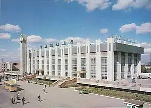
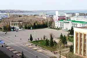 Kokshetau's central Ablai Khan Square | |
 Coat of arms | |
Nicknames:
| |
| Anthem: none | |
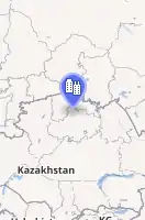  | |
 Kokshetau Location of Kokshetau in Kazakhstan  Kokshetau Kokshetau (Asia) | |
| Coordinates: 53°17′N 69°23′E | |
| Country | |
| Region | Akmola Region |
| Founded | 29 April 1824 (officially; military fortress) |
| City status since | 1895 |
| Government | |
| • Akim (mayor) | Bauyrzhan Gaisa[1] |
| Area | |
| • City and administrative centre | 234 km2 (90 sq mi) |
| • Urban | 425 km2 (164 sq mi) |
| Elevation | 234 m (768 ft) |
| Population | |
| • City and administrative centre | 146,104 |
| • Rank | 18th in Kazakhstan 1st in Akmola Region |
| • Density | 624/km2 (1,620/sq mi) |
| • Urban | 160,431 |
| Demonym(s) | Көкшетаулық (kk) Кокшетауцы (ru) Кокшетауец (ru, male) Кокшетаука (ru, female) |
| Demographics (mid-2020 est.)[4] | |
| • Kazakhs | 58.05% |
| • Russians | 29.41% |
| • Ukrainians | 2.88% |
| • Tatars | 2.28% |
| • Germans | 1.95% |
| • Poles | 1.40% |
| • Ingush | 1.07% |
| • Other | 2.96% |
| Time zone | UTC+06:00 (ALMT) |
| Postal code | 020000–020010 |
| Area code(s) | +7-7162 |
| Vehicle registration | 03 (region) (before 2012: C – on older plates) |
| Sister cities | Waukesha, Wisconsin |
| Climate | BSk |
| Highways | |
| International airports | Kokshetau (KOV) |
| Major railway stations | |
| KATO ID | 111010000[5] |
| Website | www.kokshetau.kz |

It has 146,104 inhabitants (2020 est.), up from 123,389 (1999 census), while Akmola Region had a total population of 738,587 (2019 est.), down from 1,061,820 (1989 census), making it the tenth most populous region in Kazakhstan. The city's history has been influenced by people of many nations and religions. Kokshetau retains multiethnic population, with 58% ethnic Kazakhs (up from 36%), the rest being mostly 29% ethnic Russians (down from 42%) and other ethnic groups such as Ukrainian, Tatars and Germans. Kokshetau City Administration (area of 425 km2 [164 sq mi]), with a population of roughly 160,430 residents, includes one settlement administration (which consists of the work settlement of Stantsyonny) and the Krasnoyarsk rural district, which includes two rural settlements (the villages of Krasny Yar and Kyzyl Zhuldyz).
The city is considered to have been founded in 1824 as a military fortress, while it was granted city status in 1895. It was the centre of Kokshetau Region, which was abolished in 1997. It is well known for its nature and tourist sites, such as Burabay and Zerenda, among others. Kokshetau is about 185 km (115 mi) from Petropavlovsk, 300 km (190 mi) northwest of the national capital Nur-Sultan along the A1, 318 km (198 mi) from Omsk along the A13, and 384 km (239 mi) from Kostanay. The city is served by Kokshetau Airport.
Kokshetau is an important economic, educational, and cultural centre of the Akmola Region. Kokshetau was awarded Kazakhstan City of Culture for 2021.[6]
Names and etymology
The name Kokshetau (Kazakh: Kökşetau; pronounced [køkɕetɑw]) is of Kazakh origin literally meaning a (lit. 'smoky-blue mountain'), kokshe / "көкше", meaning (lit. 'blueish') and tau / "тау", meaning (lit. 'mountain') — the name of always turning blue, as if in a deep haze of mountains. That is how from ancient times Kazakhs were calling the highest mountain in Akmola Region "Mount Kokshe" (947 m), located 60 miles away from the city.
Following the collapse of the Soviet Union and independence of Kazakhstan, on 7 October 1993, by the Resolution of the Presidium of the Supreme Council of the Republic of Kazakhstan, the city of Kokchetav (Russian: Кокчета́в, IPA: [koktɕɪˈtav]) was renamed to the more Kazakh sounding Kokshetau as part of the government's campaign to apply Kazakh names to cities, but the city's airport still retains KOV as its IATA code.
Geography
Location
The city lies in the northern portion of Akmola Region. Kokshetau is located on the border of the West Siberian Plain, on the southeastern shore of Lake Kopa, at an altitude of 234 meters above sea level, in the north of the Kokshetau Upland, the foothills of which surround the city from the south and west. It is located at 53°17′0″N 69°23′0″E and covers an area of 234 km2 (90 sq mi). It is located about 300 kilometres (190 mi) north-west of the national capital of Nur-Sultan.
There are numerous hills in the vicinity of the city (Bukpa Hill). The city is located in the flat part of the interfluve of the Kylshakty river, flowing in the eastern part of the city, and the Shagalaly river, flowing from the western side of the city. The city has several parks and gardens. Also, within the city limits can be found small forests, mostly consisting of birches and pine plantations. The Kokshetau area is known for its two national parks, Burabay and Kokshetau.
Time
The time offset from the UTC used by Kokshetau is 6 hours after UTC, or UTC+6:00 (ALMT). This is also used by most of Kazakhstan. This time apply throughout the year as Kazakhstan does not observe Daylight saving time (DST).
Administrative-Territorial Division
Kokshetau is the capital of the Akmola Region. Kokshetau city administration (area of 425 km2 [164 sq mi]), with a population of roughly 160 430 residents, includes one settlement administration and the Krasnoyarsk rural district, which includes two rural settlements.
| No. | Populated place | Population | KATO ID |
|---|---|---|---|
| 1 | selo of Krasny Yar | 111033100 | |
| 2 | p.g.t of Stantsyonny | 111037100 | |
| 3 | selo of Kyzylzhulduz | 111033300 |
Climate
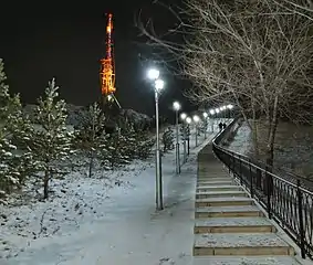
._Night._2021-22._Winter.jpg.webp)
According to the Köppen climate classification, Kokshetau lies in a cold semi-arid climate zone (Köppen climate classification: BSk) with extreme continental influences. The city has an extreme continental climate with long, very cold, frigid, snowy, dry winters and warm, dry, sunny summers (featuring occasional brief rain showers). Winter is frosty and long (more than 5 months). In spring, prevails clear and dry weather, with a large number of sunny days. Autumn begins in August or September, and the weather is observed from clear at the beginning of the season, to cloudy in October–November. The average annual temperature in Kokshetau is 3.6 °C (38.5 °F). Summer temperatures occasionally reach 35 °C (95 °F) while −30 to −35 °C (−22 to −31 °F) is not unusual between mid-December and early March.
The warmest month is July with daily mean temperature near 20.5 °C (68.9 °F), and the coldest month is January, with a daily mean of −14 °C (7 °F). Snow and ice are dominant during the winter season. July is the wettest month (averaging 68.5 mm (2.7 in) of precipitation) while March is the driest (averaging 10.5 mm (0.4 in) of precipitation). Yearly precipitation amounts to 313 mm (12.3 in). Typically, the city's Lake Kopa and rivers of Kylshakty and Shagalaly are frozen over between the second week of November and the beginning of April.
| Climate data for Kokshetau (1991–2020, extremes 1925–present) | |||||||||||||
|---|---|---|---|---|---|---|---|---|---|---|---|---|---|
| Month | Jan | Feb | Mar | Apr | May | Jun | Jul | Aug | Sep | Oct | Nov | Dec | Year |
| Record high °C (°F) | 4.0 (39.2) |
6.6 (43.9) |
18.7 (65.7) |
30.3 (86.5) |
35.5 (95.9) |
40.1 (104.2) |
39.2 (102.6) |
37.7 (99.9) |
35.0 (95.0) |
25.0 (77.0) |
16.5 (61.7) |
6.0 (42.8) |
40.1 (104.2) |
| Average high °C (°F) | −10.3 (13.5) |
−8.8 (16.2) |
−1.2 (29.8) |
10.5 (50.9) |
19.6 (67.3) |
24.3 (75.7) |
25.2 (77.4) |
23.6 (74.5) |
17.3 (63.1) |
9.1 (48.4) |
−2.2 (28.0) |
−8.1 (17.4) |
8.3 (46.9) |
| Daily mean °C (°F) | −14.3 (6.3) |
−13.2 (8.2) |
−5.7 (21.7) |
5.1 (41.2) |
13.5 (56.3) |
18.6 (65.5) |
19.6 (67.3) |
17.8 (64.0) |
11.8 (53.2) |
4.7 (40.5) |
−5.6 (21.9) |
−11.7 (10.9) |
3.4 (38.1) |
| Average low °C (°F) | −18.8 (−1.8) |
−18.0 (−0.4) |
−10.5 (13.1) |
−0.2 (31.6) |
6.9 (44.4) |
12.1 (53.8) |
13.8 (56.8) |
12.0 (53.6) |
6.4 (43.5) |
0.6 (33.1) |
−9.2 (15.4) |
−15.7 (3.7) |
−1.7 (28.9) |
| Record low °C (°F) | −42.2 (−44.0) |
−42.0 (−43.6) |
−45.0 (−49.0) |
−26.1 (−15.0) |
−8.9 (16.0) |
−5.7 (21.7) |
2.0 (35.6) |
−2.2 (28.0) |
−10.5 (13.1) |
−26.0 (−14.8) |
−42.6 (−44.7) |
−44.0 (−47.2) |
−45.0 (−49.0) |
| Average precipitation mm (inches) | 13 (0.5) |
11 (0.4) |
13 (0.5) |
20 (0.8) |
27 (1.1) |
42 (1.7) |
69 (2.7) |
43 (1.7) |
23 (0.9) |
22 (0.9) |
19 (0.7) |
15 (0.6) |
317 (12.5) |
| Average precipitation days (≥ 0.1 mm) | 3.7 | 3.4 | 3.0 | 4.2 | 6.5 | 6.5 | 8.5 | 7.3 | 5.5 | 6.2 | 4.3 | 3.3 | 62.4 |
| Mean monthly sunshine hours | 89 | 127 | 196 | 227 | 277 | 306 | 313 | 250 | 190 | 118 | 88 | 75 | 2,256 |
| Source 1: Pogoda.ru.net[7] | |||||||||||||
| Source 2: NOAA (sun and precipitation days 1961–1990)[8] | |||||||||||||
- Nearby places
The village of Krasny Yar lies adjoined directly to the west of Kokshetau, on the bank of the River Shagalaly. Also contiguous with Kokshetau, directly to the east, with no natural border, is the smaller village of Stantsyonny.
- Nearby cities: Petropavl, Nur-Sultan, Omsk (Russia) and Karaganda
- Nearby towns: Atbasar, Akkol, Ereymentau, Esil, Makinsk, Shchuchinsk, Stepnyak, Stepnogorsk
- Nearby villages: Zerendi
Destinations from Kokshetau | ||||||||||||||||
|---|---|---|---|---|---|---|---|---|---|---|---|---|---|---|---|---|
| ||||||||||||||||
History
_-_1890_(panoramic_view%252C_Aqmola_Region%252C_Kazakhstan).jpg.webp)
Kokshetau has a rich centuries-old past, which has incorporated all the main stages and turning points of the history of Kazakhstan. The territory of modern-day Kokshetau has seen the rise and fall of many cultures and empires. For many centuries, nomadic Kazakh tribes lived on the territory of the former Kokshetau Region. The territory of Kokshetau was part of the Middle Horde, the clans of the tribal union of the Argyns that occupied vast regions of Northern and Central Kazakhstan.[9] In the 18th – 19th centuries, the headquarters of famous khans, such as Abylai Khan, Kasym Khan, Kenesary Khan, were located on the land of Kokshetau Region.
As Russia's hand stretched southwards, Kokshetau was initially founded on 29 April 1824 by Cossacks as an administrative outpost at the foot of the southern side of Mount Kokshe on the shores of Lake Ulken Shabakty. The local population strongly opposed the fact that the new settlement was placed in the chosen place. In the summer of 1827, the district order was transferred to the new place where the city of Kokshetau is now located. The settlement began to be called Kokchetav. The construction of the settlement began at the foot of Bukpa Hill, on the southern shores of Lake Kopa, and a Cossack picket was set up to protect the district order.[10]
By the middle of 19th-century, the population of the settlement was significantly increasing due to the migration of the peasants from Russia (Povolzhye) and Ukraine who were driven to migrate by starvation and poverty to farm the steppe. In 1868, when the Akmolinsk Oblast was formed, Kokshetau became a district city in this region, which further developed as a center of agricultural and animal husbandry and as a resort town. In 1876, the city lost its military significance. The line and fortress were abolished. In 1895, Kokshetau was granted city status.[11] By that time the population in the town was above 5 thousand people.[12]
In 1928, Kokshetau District was divided into several boroughs and until 1944 Kokshetau's territory was part of Karaganda Region and later part of North Kazakhstan Region. On 16 March 1944, according to the Decree of the Presidium of Supreme Soviet of Kazakh SSR, Kokshetau became the administrative center of the newly created Kokchetav Oblast. Relatively rapid growth and development of Kokshetau took place during the years of development of virgin lands, especially in the second half of the 1950s.[13] In the spring of 1997, Kokshetau Oblast was abolished, the city was deprived of the status of a regional center. On 8 April 1999, after Akmola and North Kazakhstan regions were reorganized, Kokshetau became the center of Akmola Region.[14]
Demographics
| Year | Pop. | ±% |
|---|---|---|
| 2010 | 136,100 | — |
| 2011 | 137,217 | +0.8% |
| 2012 | 136,835 | −0.3% |
| 2013 | 139,063 | +1.6% |
| 2014 | 140,847 | +1.3% |
| 2015 | 142,411 | +1.1% |
| 2016 | 145,795 | +2.4% |
| 2017 | 145,531 | −0.2% |
| 2018 | 145,789 | +0.2% |
| 2019 | 145,161 | −0.4% |
| 2020 | 146,104 | +0.6% |
| Source: Kokshetau, Kazakhstan: Historical statistics – Population[15] | ||
Kokshetau is the eighteenth-largest city in Kazakhstan. Kokshetau is an ethnically and culturally diverse city. Kokshetau ranks fourth in terms of population in Northern Kazakhstan, ranking after Pavlodar, Kostanay and Petropavl. It has changed its demographics, nowadays having more ethnic Kazakhs in a city that formerly had a Slavic majority. It is the only regional center in Northern Kazakhstan where Kazakhs make up the majority. Despite Kokshetau's Kazakh majority, Russian is the dominant language in the city. It is also common to find the Kazakh being spoken in the city, mainly by Kazakhs and other Turkic people. Residents of Kokshetau are referred to as Kökşetaulyqtar in Kazakh and Kokshetautsy in Russian.
Histogram of population evolution of Kokshetau from 1959.
| 1897 | 1959 | 1970 | 1979 | 1989 | 1991 | 1999 | 2004 | 2005 | 2006 | 2007 | 2008 | 2009 |
|---|---|---|---|---|---|---|---|---|---|---|---|---|
| 4,962 | 52,909 | 80,564 | 103,162 | 136,757 | 143,300 | 123,389 | 123,640 | 125,455 | 127,317 | 129,244 | 131,215 | 135,106 |
| 2010 | 2011 | 2012 | 2013 | 2014 | 2015 | 2016 | 2017 | 2018 | 2019 | 2020 | ||
| 136,100 | 137,217 | 136,835 | 139,063 | 140,847 | 142,411 | 145,795 | 145,531 | 145,789 | 145,161 | 146,104 |
Note: 2020 and 2018 are population estimates; 1897 is the Russian Imperial Census; 1959, 1970, 1979 and 1989 are the Soviet Census.
Ethnic and national composition
As of January 2020, the population of Kokshetau is 146,104, and the extended urbanized area has 160,431 inhabitants.
Historically, Kokshetau was ethnically diverse. As of the 2020 Census, ethnic Kazakhs made up (~58%) of the city population, representing an increase from 36% in 1999. The ethnic makeup of the city's population as of year 2020 was:[16]
|
|
In 1989, Kokshetau had a population of 136,757. The ethnic mix was about 18.5% Kazakh, 54.5% Russian and 27.0% other ethnic groups.
| Ethnicity | Number | Percentage |
|---|---|---|
| Russians | 74,481 | 54.5% |
| Kazakhs | 25,300 | 18.5% |
| Others | 36,976 | 27.0% |
Religion
_(2).jpg.webp)
The city's religious profile is highly diverse. Islam (primarily Sunni Islam) is the predominant religion within Kokshetau. Other religions practiced are Christianity (primarily Russian Orthodox, Roman Catholicism, and Protestantism).
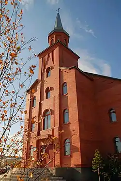
Kokshetau has a beautiful mosque constructed in the beginning of the 20th century and a Russian Orthodox Church temple of Archangel Michael. The Kokshetau and Akmola diocese is located in the Church of the Resurrection in the city. In 1997, a Roman Catholic Church was built in neo-Gothic style using red bricks. A new mosque for 1,200 people named after Nauan Hazrat opened in 2015 and construction of a new Orthodox Church is underway.
Mosques:
- Nauan Hazrat Mosque (capacity 1,200—1,400), located at the corner of Momishuly and Auelbekov streets.
- Zhakiya Kazhi Mosque
Russian Orthodox churches:
- Church of the Resurrection, Kokshetau (capacity 1,500), (ROC)
- Church of the Holy Archangel Michael, Kokshetau, (ROC)
- St George's Church, Kokshetau
Roman Catholic churches:
Culture
.jpg.webp)
.jpg.webp)
Theatres
Kokshetau has a strong theater culture.
- Akmola Regional Russian Drama Theater (opened in 1977), which also incorporates Palace of Culture
- Akmola Regional Philharmonic named after Ukili Ybyrai (opened in 1956)
- Akmola Regional Kazakh Music and Drama Theatre named after Shayakhmet Kussainov (opened in 1996)
Museums
- Akmola Regional Museum of History and Local Lore (opened in 1920)
- Kokshetau City History Museum (KCHM)
- Museum of Literature and Art (opened in 1989)
- Museum of the Hero of the Soviet Union Malik Gabdullin (opened in 1993), located at the corner of Auelbekov and Nazarbayev streets, on the eastern side of the town centre.
Cinemas
The first film screening in the city of Kokchetav (now Kokshetau) took place in 1910.
- Cinema Alem
Libraries
- Akmola Regional Universal Scientific Library (ARUSL) named after Magzhan Zhumabayev
Economy
Kokshetau has traditionally been an important commercial center in northern Kazakhstan, but after the collapse of the Soviet Union most of the old manufacturing lines either stopped working or had to greatly reduce their operations. Nevertheless, the city continues to be an important regional center for the Akmola Region, acting as a commercial hub for the surrounding areas in the region. In recent years, the city has started attracting more investment from various corporations.
Large industrial enterprises of Kokshetau include: gold mining enterprise JSC "Altyntau Kokshetau"; JSC "Tynys" – the production of medical products, weighing equipment, water meters, aircraft units and assemblies, polyethylene pipes; machine-building plant OJSC "KamAZ-Engineering"; JSC "Kokshetau Mineral Waters". Food factories supply Kokshetau and Akmola Region with sausages, semi-finished meat products, bread, dairy products, and confectionery. The city also has a gold recovery factory and a new ceramic brick factory.
From Ekibastuz to Kokshetau runs an overhead power line designed for a transmission voltage of 1,150 kV, the Ekibastuz-Kokshetau powerline.
Media
Kokshetau is the center of television and radio broadcasting in Akmola Region. All major Kazakhstani newspapers are active in Kokshetau. There are local TV stations, the Internet, and print media. The city has a developed telecommunications system.
Newspapers
Kokshetau's first newspaper was the weekly Tselinnyy kray, established in 1920, which would change its name to the Akmolinskaya Pravda in 1992. In the city, there are some popular urban newspapers. Akmolinskaya Pravda, Stepnoy mayak and Kokshetau are Russian-language media headquartered in the city. Akmolinskaya Pravda is the oldest newspaper of the city.
- Regional socio-political newspaper "Akmolinskaya Pravda"
- Republican newspaper "Bukpa"
- Regional newspaper "Arka Azhary"
- Regional newspaper "Stepnoy mayak"
TV and radio
Kokshetau television networks:
- TV channel Kazakhstan–Kokshetau
- Balapan
- Cartoon Network
- Channel One Eurasia
- Channel 31
- Disney Channel
- Euronews
- Gakku TV
- Khabar 24
- MTV
- Nickelodeon
- Qazsport
Kokshetau radio stations:
- "Kazakh Radio": 101.0 FM
- "Russian Radio Asia": 102.0 FM
- "Autoradio Kazakhstan": 102.5 FM
- "Shalkar Radio": 103.7 FM
- "Europe Plus Kazakhstan": 104.2 FM
- "Energy FM": 104.8 FM
- "Radio NS": 105.7 FM
- "Zhuldyz FM": 106.1 FM
- "Radio Dacha": 106.5 FM
- "People's Radio": 107.0 FM
- "Tengri FM": 107.6 FM
Transport
 Kokshetau Railway Station. View from Privokzal'naya Ploshchad', 1992
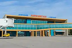 Terminal building and apron area of the Kokshetau Airport (KOV)
 Train No. 057X Nur-Sultan - Oral, under the electric locomotive KZ4AT-0012 at Kokshetau-1 station, 2019
Partly due to its location, Kokshetau is a major transport hub on the highway and rail networks.
City transport
The city transport in Kokshetau consists of a network of buses, minibuses (marshrutka) and taxis that are available 24 hours a day. Public transport in Kokshetau is heavily privatized and mostly handled by private operators.
Railway and intercity bus
The city is an important railroad hub in the northern part of Kazakhstan. The first train pulled into the Kokshetau Railway station on 2 June 1922. Railways are Kokshetau's one of the main modes of intracity and suburban transportation. Kazakhstan Railways provide freight and passenger traffic to and from Kokshetau.
There are two railway stations in the city: Kokshetau-1 and Kokshetau-2. The main railway station Kokshetau-1 station is located 1.3 km (0.81 mi) north-east from the centre of Kokshetau and includes a main building (built in 1981) and some other technical buildings. Kokshetau-1 station is the city's main station and a major stop for numerous passenger trains traveling between Nur-Sultan and the other regions of Kazakhstan each day.
There is also Kokshetau Central Bus Terminal that links Kokshetau with the villages in Akmola Region and other cities in Kazakhstan and the neighboring countries. Frequent schedules of bus routes connect Kokshetau to Petropavl, Nur-Sultan, Karaganda, Pavlodar, Kostanay, Omsk, Yekaterinburg, Tobolsk, Tyumen and Kurgan. Many of these are cross-country services operating from north to south, for which Kokshetau provides interchange facilities.
Air travel
Kokshetau and surrounding communities are served by one commercial international airport: Kokshetau International Airport (IATA Airport code: KOV), which is the seventeenth-busiest airport (2019) by passenger traffic in Kazakhstan. It is located 12.5 km (7.8 mi) north-east from the centre of city, on the route to Omsk, and used to be the headquarters of now-defunct Air Kokshetau. The airport has a capacity of handling 200 passengers per hour. The Kokshetau International Airport, which opened in 1945, was significantly upgraded in 2013 with a new 2850-metre runway capable of accommodating all aircraft types without any restrictions.[18] In 2013, the airport received its first scheduled flight after the renovation to Moscow, Russia. The airport can be reached by car, public transport, or taxi. Seasonal flights to Frankfurt am Main, were available in 2004 but have been cancelled since. It serves mostly domestic flights. SCAT Airlines fly to and from Almaty, Aktau and Turkistan as well as FlyArystan operates three weekly flights to Almaty. The former largest carrier of the Kokshetau Airport — Air Kokshetau — is not serving any regular destinations as of 2021.
Highways
Kokshetau has connections to Nur-Sultan (292 km [181 mi]) and Petropavl (189 km [117 mi]) by the A1. European route ![]() intersect in Kokshetau.
intersect in Kokshetau.
Other major roads passing through Kokshetau include:
- The R11 highway connects Kokshetau to Kostanay (via the M36);
- The R12 highway connects Kokshetau to Atbasar
Architecture
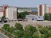 The view of Independence Square in 2021.
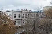 Historical building in the centre of Kokshetau.
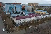 Panorama to the historical center of Kokshetau.
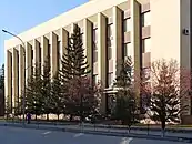 Main facade of the administrative building of Akmola Region, an example of Soviet Kokshetau architecture.
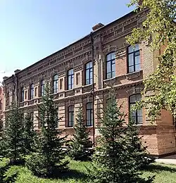
The city is full of numerous buildings and monuments that reflect its rich and diverse history. The architecture of Kokshetau has been shaped through its history by the progression of historical eras. Many buildings of Kokshetau are ranged from a different number of architectural styles. The architecture of the city dates back to 19th century, the city had numerous wooden buildings with elaborate decor. Kokshetau is the home of a unique architectural tradition and community with number of historical buildings in city. Industrialization in Kokshetau started in the late 1920s. There are a number of two-story wooden houses in the city built mostly in the middle of the 20th century as temporary habitations. Among other notable buildings are the mansions of the merchant Andrei Vasilievich Sokolov (late of the 19th century - beginning of the 20th century), the Akmola Regional Museum of History and Local Lore (beginning of the 20th century). The city’s apartment houses are called “Khrushchyovka” and “Stalinka” due to the peculiarities of architectural approaches in their construction.
Education
Kokshetau is a regional centre of education and has a large number of educational establishments, including universities, professional colleges and gymnasiums (high schools). Primary and secondary schools in Kokshetau include state-run and private institutions.
Post-secondary education
The city is currently home to the following state higher educational institutions:
| Name | Established | City | Type | Students | Academic staff |
|---|---|---|---|---|---|
| Kokshetau State University (named after Sh.Ualikhanov) | 1962 | Kokshetau | Public classic university | 8,000 | 499 |
- Kokshetau Technical Institute of the Ministry of Emergency Situations of the Republic of Kazakhstan
- Kokshetau Academy of Economics and Management
A number of other non-state-funded institutions for further education operate in the city.
Sport
Sport has always been important in Kokshetau. Football and ice hockey are by far the most popular sports in the city. Kokshetau has many parks that provide excellent pitches for impromptu games. The city is home to the FC Okzhetpes football club, based in the Okzhetpes Stadium, and which has a capacity of 4,500, which participates in the Kazakhstan Premier League, the top division of football in Kazakhstan. In 2015 and 2018, they finished first place in the Kazakhstan First Division. A number of well-known athletes, both world and Olympics champions, are associated with the city.
Burabay Sports Complex serves as home arena to the ice hockey club Arlan Kokshetau, which competes in the Kazakhstan Hockey Championship. Arlan Kokshetau hockey players were the champions of Kazakhstan in the season 2017/2018. Arlan Kokshetau players also became the first team from Kazakhstan to win IIHF Continental Cup in the season 2018/2019. The city has an ice rink for winter sports. Several sports clubs are active in the city:
| Club | Sport | Current league | Founded | Stadium | Championships |
|---|---|---|---|---|---|
| Arlan Kokshetau | Ice Hockey | Kazakhstan Hockey Championship | Burabay Sports Complex | ||
| FC Okzhetpes Kokshetau | Football | Kazakhstan Premier League | Okzhetpes Stadium | ||
Parks and recreation
Kokshetau is home to a large number of parks and recreation areas.
- City Park, the city's largest and oldest park, established in 1957.
International relations
See also
- Category: People from Kokshetau
- European route E125
- Kokshetau Mountain
- Kokshetau National Park
- Kokshetau Region
- List of cities in Kazakhstan
References
| Wikimedia Commons has media related to Kokshetau. |
- Поддержали единогласно
- "Results Of The 2009 National Population Census Of The Republic Of Kazakhstan Analytical Report" (PDF). The Agency On Statistics of the Republic of Kazakhstan.
- "Archived copy". Archived from the original on 26 May 2011. Retrieved 22 October 2009.
{{cite web}}: CS1 maint: archived copy as title (link) - "Численность населения Республики Казахстан по отдельным этносам на начало 2020 года". Комитет по статистике Министерства национальной экономики Республики Казахстан. Retrieved 28 April 2020.
- "База КАТО". Комитет по статистике Министерства национальной экономики Республики Казахстан. Retrieved 19 June 2017.
- "Kokshetau Named Cultural Capital of Kazakhstan in 2021". Retrieved 21 May 2021.
- "Погода и Климат – Климат Кокшетау" (in Russian). Weather and Climate (Погода и климат). Retrieved 8 November 2021.
- "Kokshetay (Kokshetau) Climate Normals 1961–1990". National Oceanic and Atmospheric Administration. Retrieved 8 November 2021.
- "The population of Kokshetau. Kazakhstan, the city of Kokshetau: population". Retrieved 21 December 2020.
- Map of Kazakhstan Akmolinskaya Oblast 1868 Sibir Kirgizy
- "History of the town". Retrieved 21 December 2020.
- "Kokshetau: the area of blue lakes". Retrieved 21 December 2020.
- "Akmola region". Retrieved 21 December 2020.
- "Kokshetau city (Kokchetav) in Akmola Region, Kazakhstan". Retrieved 21 December 2020.
- Cities & towns of Kazakhstan
- "Численность населения Республики Казахстан по отдельным этносам на начало 2020 года". Stat.kz. Retrieved 6 August 2020.
- "Religious composition of the population of Kazakhstan in 2009". Retrieved 22 July 2021.
- "Reconstruction of Kokshetau Airport".
External links
- Official web site (in Kazakh, Russian, and English)
- 360° QTVR fullscreen panoramas of the Kokshetau
- Visitaqmola.kz – Tourism website for Akmola Region (in Kazakh, Russian, and English)
| Geography | | |
|---|---|---|
| Transportation | ||
| Religious buildings | ||
| ||
Capital: Kokshetau | ||
| City Administration | 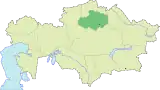 | |
| Districts | ||
| Major cities | ||