Knaptoft
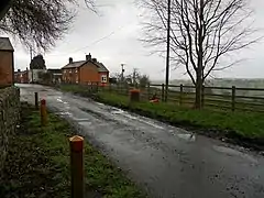
Knaptoft is a deserted medieval village and civil parish in the Harborough district of Leicestershire and lies approximately 9.7 miles (15.6 km) south of the city of Leicester, England. According to the University of Nottingham English Place-names project, the settlement name Knaptoft could mean 'cnafa' (Old English) A boy, a young man, a servant, a menial, or a personal name, and 'toft' (Old English) the plot of ground in which a dwelling stands.[1] The population of the civil parish at the 2011 census was 47.[2]
| Knaptoft | |
|---|---|
 Knaptoft | |
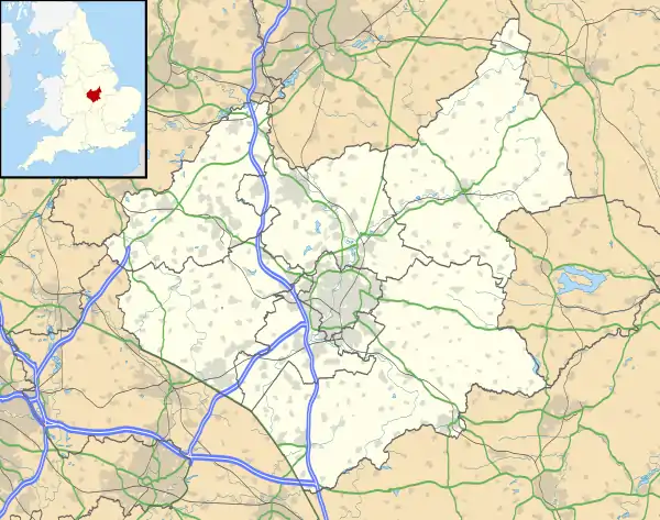 Knaptoft Location within Leicestershire | |
| Area | 2.227809 sq mi (5.77000 km2) |
| Population | 47 (2011) |
| • Density | 21/sq mi (8.1/km2) |
| OS grid reference | SP627896 |
| • London | 80.13 mi (128.96 km) |
| Civil parish |
|
| District | |
| Shire county | |
| Region | |
| Country | England |
| Sovereign state | United Kingdom |
| Post town | LEICESTER |
| Postcode district | LE17 |
| Dialling code | 0116 |
| Police | Leicestershire |
| Fire | Leicestershire |
| Ambulance | East Midlands |
| UK Parliament | |
| Website | Knaptoft Parish Council |
Geography
Knaptoft is situated on a ridge due south of Shearsby 0.85 miles (1.37 km), between the villages of Bruntingthorpe 1.51 miles (2.43 km) to the west and Mowsley to the east 1.31 miles (2.11 km). The soils are "Slowly permeable seasonally wet slightly acid but base-rich loamy and clayey soils", according to UK Soil Observatory results.[3] The site of the settlement is mainly situated on Till (a superficial deposit formed up to 2 million years ago in the Quaternary Period), with a strip of Lacustrine deposits on the western end that is underpinned by Dyrham Formation (grey siltstone, 183-191 million years old), with Charmouth Mudstone (105-180 million years old) to the western end of the village.[4]
History
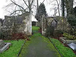
Mentioned in the Domesday Book Survey of 1086, Knaptoft was a settlement in the Hundred of Guthlaxton, Leicestershire. It had an estimated population of 22 households in 1086.[5] The village Church of St. Nicholas is now a ruin and is a Grade II listed building.[6] Although it is thought to have been built in 1279,[7] the surviving church remains appear to be 13th century, but subsequent reparations to the damaged walls in the early 20th century has made it difficult to confirm.[8]
Knaptoft is clearly visible on the 1576 map of Warwickshire and Leicestershire, produced (in Latin) by Christopher Saxton as part of his Atlas of England and Wales,[9] but the cartographic style provides no evidence of village size.
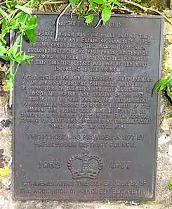
In 1301 the village was known to comprise a manor, a windmill, 2 fish ponds and 20 tenants. Between the years 1525-1530 a manor house was built on what is known as the site of Knaptoft Hall, by the Turpin family.[10] By 1624 the village housed five labourers alongside a church and a manor. The depopulation was thought to be due to the enclosure of the land for sheep pasture, which required less labour.[11]
The old site of Knaptoft Hall Farm, west of the church ruins, is thought to be the site of the old manor Hall. The manor was held by the Horton family from 1279 to 1761. The first of this line was Henry de Horton who became a free tenant in 1279 and built the manor next to the church. The old manor was demolished in 1761 and a new house built on the site.[11] In 1625, the village purchased a bell for the church and in 1630 the church was noted to be still standing.[12] It is thought, however, to have been sacked and destroyed by Oliver Cromwell's Roundhead forces after the Battle of Naseby in June 1645 whilst in pursuit of the fleeing defeated Royalist army. Evidence supports that a skirmish occurred here, based on archaeological finds.[11]
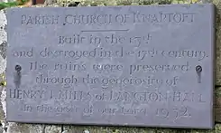
At some point during the mid to late 18th century, the bell that was bought by the village in 1625 was forcefully intercepted by villagers in Shearsby for their own church, while it was on transit to be installed (by request of the Duke of Rutland) in the church in Aylestone, Leicester.[13] By 1792, the church was recorded to be in ruin, with much of it's fabric used to repair local roads.[12]
A survey of the villages in the area by John Nichols recorded that only five freeholders were polled in Knaptoft in 1719, and that by 1775, there were none.[12] In 1778, not long after the Enclosure Act of 1773, it was recorded that out of the 1,370 acres of parish land, 141 belonged to Thomas Turvile, esq. and the rest belonged to the Duke of Rutland, as Lord of the Manor.[12] By 1790, the village had 7 houses but the manor Hall was now in a derelict state (see etchings of Knaptoft and the manor Hall in 1790).[14] When John Nichols visited Knaptoft 15 years later, the manor Hall was a ruin.[12]
The ancient parish of Knaptoft included the chapelries of Shearsby and Mowsley and the hamlet of Walton in Knaptoft, all of which became separate civil parishes in 1866. By the 1870s, the village managed to maintain 7 houses, along with 54 residents.[15]
Knaptoft today
The Church of Saint Nicholas is now roofless but still contains headstones and the stone font. Open air church services continue to be held at the church at 3pm on the third Sunday of June, July, August and September,[16] and Coarse fishing at the Knaptoft medieval fishponds are still active. These ponds were populated by a small number of Roach, Rudd, and Tench that were brought in from the existing medieval fishpond at the old Knaptoft Hall farm site.
References
- "Key to English Place-names". kepn.nottingham.ac.uk. Retrieved 6 April 2022.
- "Knaptoft parish postcodes". doogal.co.uk. doogal.co.uk. Retrieved 6 April 2022.
- "Soil Type: Soilscapes for England and Wales". ukso.org. UK Research and Innovation (UKRI). Retrieved 6 April 2022.
- "Geological Survey of England and Wales 1:63,360/1:50,000 geological map series, New Series (Sheet 170)". largeimages.bgs.ac.uk. British Geological Survey. Retrieved 6 April 2021.
- "Knaptoft, Leicestershire". opendomesday.org. Open Domesday. Retrieved 6 April 2022.
- Historic England. "Church Ruin (Grade II) (1061481)". National Heritage List for England. Retrieved 9 April 2022.
- "Parish Church of St. Nicholas". stnicholascenter.org. St Nicholas Center. Retrieved 9 April 2022.
- "Church Ruins". historicengland.org.uk. Historic England. Retrieved 9 April 2022.
- Christopher Saxton (1576). Saxton’s map of Warwickshire and Leicestershire (Map). Great Britain. Her Majesty's Stationery Office. Taylowe Limited. Terwoort, Lenaert.
- "Leicestershire and Rutland HER: Knaptoft". heritagegateway.org.uk. Heritage Gateway. Retrieved 9 April 2022.
- "Knaptoft Church St Nicholas". leicestershirechurches.co.uk. Leicestershire & Rutland Churches. Retrieved 9 April 2022.
- Nichols, John (1807). The history and antiquities of the county of Leicester : Vol. 4, Part 1. Vol. 4. United Kingdom -- England -- Leicestershire: Printed for the author by J. Nichols. pp. 216–225.
- Nichols, John (1790). The supplementary volume to the Leicestershire views: containing a series of excursions in the year 1790, to the villages and places of note in the county. United Kingdom -- England -- Leicestershire: Printed for the author by J. Nichols. p. 196.
- Nichols, John (1807). The history and antiquities of the county of Leicester : Vol. 4, Part 1. Vol. 4. United Kingdom -- England -- Leicestershire: Printed for the author by J. Nichols. p. 221.
- "A Vision of Britain Through Time: Knaptoft, Leicestershire". visionofbritain.org.uk. Great Britain Historical GIS Project (2017) 'Great Britain Historical GIS'. University of Portsmouth. Retrieved 9 April 2022.
- "St Nicholas' church - Knaptoft, Leicestershire - Anglican and Episcopal Churches". waymarking.com. Groundspeak. Retrieved 9 April 2022.
External links
| Wikimedia Commons has media related to Knaptoft. |