Kitaakita
Kitaakita (北秋田市, Kitaakita-shi) is a city located in Akita Prefecture, Japan. As of 30 November 2019, the city had an estimated population of 31,504 in 14,021 households,[1] and a population density of 27 persons per km². The total area of the city is 1,152.76 square kilometres (445.08 sq mi).
Kitaakita
北秋田市 | |
|---|---|
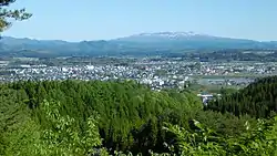 Panorama view of downtown Kitaakita | |
 Flag  Seal | |
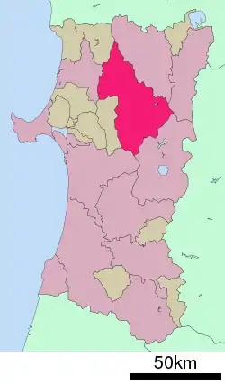 Location of Kitaakita in Akita Prefecture | |
 Kitaakita | |
| Coordinates: 40°13′33.7″N 140°22′14.9″E | |
| Country | Japan |
| Region | Tōhoku |
| Prefecture | Akita |
| Government | |
| • -Mayor | Eiko Tsuya <津谷永光> (from April 2009) |
| Area | |
| • Total | 1,152.76 km2 (445.08 sq mi) |
| Population (November 2019) | |
| • Total | 31,504 |
| • Density | 27/km2 (71/sq mi) |
| Time zone | UTC+9 (Japan Standard Time) |
| Phone number | 0186-62-1111 |
| Address | Hanazono-chō 19-1, Kitaakita-shi, Akita-ken 018-3392 |
| Climate | Cfa/Dfa |
| Website | Official website |
| Symbols | |
| Bird | Black woodpecker |
| Flower | Hydrangea |
| Tree | Beech |

Geography
Kitaakita is located in the mountains of northeastern Akita Prefecture, with the Ōu Mountains on the east. Part of the city is within the borders of the Towada-Hachimantai National Park. Much of the city area is covered in forest. Due to its inland location, the city is noted for its heavy snowfall in winter. It is approximately 80 kilometers northeast of Akita City, the prefectural capital.
Climate
Kitaakita has a humid continental climate (Köppen climate classification Dfa) with large seasonal temperature differences, with warm to hot (and often humid) summers and cold (sometimes severely cold) winters. Precipitation is significant throughout the year, but is heaviest from August to October. The average annual temperature in Kitaakita is 10.5 °C (50.9 °F). The average annual rainfall is 1,704.7 mm (67.11 in) with July as the wettest month. The temperatures are highest on average in August, at around 23.7 °C (74.7 °F), and lowest in January, at around −1.5 °C (29.3 °F).[2]
| Climate data for Takanosu, Kitaakita (1991−2020 normals, extremes 1976−present) | |||||||||||||
|---|---|---|---|---|---|---|---|---|---|---|---|---|---|
| Month | Jan | Feb | Mar | Apr | May | Jun | Jul | Aug | Sep | Oct | Nov | Dec | Year |
| Record high °C (°F) | 10.6 (51.1) |
17.6 (63.7) |
20.4 (68.7) |
30.0 (86.0) |
32.5 (90.5) |
34.0 (93.2) |
37.4 (99.3) |
38.6 (101.5) |
37.9 (100.2) |
28.6 (83.5) |
23.0 (73.4) |
16.0 (60.8) |
38.6 (101.5) |
| Average high °C (°F) | 1.7 (35.1) |
2.9 (37.2) |
7.1 (44.8) |
14.3 (57.7) |
20.2 (68.4) |
24.4 (75.9) |
27.5 (81.5) |
29.0 (84.2) |
24.9 (76.8) |
18.2 (64.8) |
10.9 (51.6) |
4.2 (39.6) |
15.4 (59.8) |
| Daily mean °C (°F) | −1.5 (29.3) |
−0.9 (30.4) |
2.3 (36.1) |
8.2 (46.8) |
14.2 (57.6) |
18.8 (65.8) |
22.6 (72.7) |
23.7 (74.7) |
19.1 (66.4) |
12.2 (54.0) |
6.0 (42.8) |
0.8 (33.4) |
10.5 (50.8) |
| Average low °C (°F) | −4.7 (23.5) |
−4.7 (23.5) |
−2.1 (28.2) |
2.5 (36.5) |
8.7 (47.7) |
14.0 (57.2) |
18.7 (65.7) |
19.4 (66.9) |
14.6 (58.3) |
7.4 (45.3) |
1.8 (35.2) |
−2.2 (28.0) |
6.1 (43.0) |
| Record low °C (°F) | −17.6 (0.3) |
−17.8 (0.0) |
−15.3 (4.5) |
−9.2 (15.4) |
−1.9 (28.6) |
4.9 (40.8) |
6.7 (44.1) |
9.8 (49.6) |
3.0 (37.4) |
−1.7 (28.9) |
−8.8 (16.2) |
−14.5 (5.9) |
−17.8 (0.0) |
| Average precipitation mm (inches) | 116.7 (4.59) |
92.4 (3.64) |
97.0 (3.82) |
103.4 (4.07) |
116.3 (4.58) |
119.8 (4.72) |
214.7 (8.45) |
198.1 (7.80) |
164.7 (6.48) |
162.7 (6.41) |
167.8 (6.61) |
151.4 (5.96) |
1,704.7 (67.11) |
| Average snowfall cm (inches) | 183 (72) |
145 (57) |
68 (27) |
1 (0.4) |
0 (0) |
0 (0) |
0 (0) |
0 (0) |
0 (0) |
0 (0) |
8 (3.1) |
113 (44) |
514 (202) |
| Average precipitation days (≥ 1.0 mm) | 21.7 | 17.7 | 15.7 | 12.5 | 12.0 | 10.3 | 13.0 | 11.4 | 12.3 | 14.9 | 17.6 | 21.6 | 180.7 |
| Average snowy days (≥ 3 cm) | 19.9 | 17.0 | 9.3 | 0.2 | 0 | 0 | 0 | 0 | 0 | 0 | 1.2 | 12.6 | 60.2 |
| Mean monthly sunshine hours | 49.1 | 74.0 | 123.6 | 171.3 | 184.1 | 176.9 | 149.4 | 180.0 | 149.9 | 132.3 | 88.9 | 47.4 | 1,528.2 |
| Source: Japan Meteorological Agency[3][2] | |||||||||||||
| Climate data for Aniai, Kitaakita (1991−2020 normals, extremes 1976−present) | |||||||||||||
|---|---|---|---|---|---|---|---|---|---|---|---|---|---|
| Month | Jan | Feb | Mar | Apr | May | Jun | Jul | Aug | Sep | Oct | Nov | Dec | Year |
| Record high °C (°F) | 11.1 (52.0) |
16.1 (61.0) |
19.0 (66.2) |
28.8 (83.8) |
32.0 (89.6) |
33.3 (91.9) |
36.3 (97.3) |
37.1 (98.8) |
34.3 (93.7) |
27.4 (81.3) |
24.3 (75.7) |
18.2 (64.8) |
37.1 (98.8) |
| Average high °C (°F) | 1.0 (33.8) |
2.1 (35.8) |
6.0 (42.8) |
13.5 (56.3) |
20.2 (68.4) |
24.2 (75.6) |
27.4 (81.3) |
28.7 (83.7) |
24.3 (75.7) |
17.6 (63.7) |
10.6 (51.1) |
3.6 (38.5) |
14.9 (58.9) |
| Daily mean °C (°F) | −2.0 (28.4) |
−1.6 (29.1) |
1.4 (34.5) |
7.4 (45.3) |
13.9 (57.0) |
18.3 (64.9) |
22.1 (71.8) |
23.1 (73.6) |
18.6 (65.5) |
11.8 (53.2) |
5.6 (42.1) |
0.3 (32.5) |
9.9 (49.8) |
| Average low °C (°F) | −5.0 (23.0) |
−5.0 (23.0) |
−2.6 (27.3) |
1.8 (35.2) |
8.0 (46.4) |
13.1 (55.6) |
17.9 (64.2) |
18.7 (65.7) |
14.2 (57.6) |
7.3 (45.1) |
1.7 (35.1) |
−2.5 (27.5) |
5.6 (42.1) |
| Record low °C (°F) | −16.4 (2.5) |
−17.2 (1.0) |
−15.8 (3.6) |
−8.5 (16.7) |
−1.3 (29.7) |
5.2 (41.4) |
9.5 (49.1) |
9.8 (49.6) |
3.2 (37.8) |
−0.7 (30.7) |
−7.8 (18.0) |
−12.6 (9.3) |
−17.2 (1.0) |
| Average precipitation mm (inches) | 164.3 (6.47) |
125.0 (4.92) |
132.0 (5.20) |
131.8 (5.19) |
133.9 (5.27) |
136.6 (5.38) |
233.8 (9.20) |
240.0 (9.45) |
193.9 (7.63) |
191.2 (7.53) |
218.0 (8.58) |
199.3 (7.85) |
2,099.7 (82.67) |
| Average snowfall cm (inches) | 259 (102) |
198 (78) |
127 (50) |
13 (5.1) |
0 (0) |
0 (0) |
0 (0) |
0 (0) |
0 (0) |
0 (0) |
21 (8.3) |
170 (67) |
778 (306) |
| Average precipitation days (≥ 1.0 mm) | 24.2 | 20.0 | 18.1 | 13.8 | 12.4 | 10.9 | 13.5 | 12.7 | 13.0 | 15.5 | 18.9 | 23.4 | 196.4 |
| Average snowy days (≥ 3 cm) | 22.4 | 18.6 | 15.0 | 2.0 | 0 | 0 | 0 | 0 | 0 | 0 | 2.3 | 14.2 | 74.5 |
| Mean monthly sunshine hours | 31.6 | 52.8 | 97.8 | 156.6 | 188.3 | 180.9 | 150.4 | 171.5 | 146.7 | 124.7 | 75.3 | 40.0 | 1,422.9 |
| Source: Japan Meteorological Agency[4][5] | |||||||||||||
| Climate data for Odate–Noshiro Airport, Kitaakita (2003−2020 normals, extremes 2003−present) | |||||||||||||
|---|---|---|---|---|---|---|---|---|---|---|---|---|---|
| Month | Jan | Feb | Mar | Apr | May | Jun | Jul | Aug | Sep | Oct | Nov | Dec | Year |
| Record high °C (°F) | 9.3 (48.7) |
17.1 (62.8) |
19.2 (66.6) |
28.6 (83.5) |
31.3 (88.3) |
33.0 (91.4) |
35.6 (96.1) |
37.3 (99.1) |
35.6 (96.1) |
26.7 (80.1) |
22.7 (72.9) |
15.4 (59.7) |
37.3 (99.1) |
| Average high °C (°F) | 0.9 (33.6) |
2.2 (36.0) |
6.4 (43.5) |
13.4 (56.1) |
19.8 (67.6) |
24.0 (75.2) |
26.8 (80.2) |
28.6 (83.5) |
24.3 (75.7) |
17.6 (63.7) |
10.6 (51.1) |
3.6 (38.5) |
14.9 (58.7) |
| Daily mean °C (°F) | −2.0 (28.4) |
−1.5 (29.3) |
1.8 (35.2) |
7.4 (45.3) |
13.7 (56.7) |
18.3 (64.9) |
22.0 (71.6) |
23.3 (73.9) |
18.8 (65.8) |
11.7 (53.1) |
5.7 (42.3) |
0.3 (32.5) |
10.0 (49.9) |
| Average low °C (°F) | −5.3 (22.5) |
−5.5 (22.1) |
−2.6 (27.3) |
1.5 (34.7) |
7.9 (46.2) |
13.1 (55.6) |
18.0 (64.4) |
19.1 (66.4) |
14.1 (57.4) |
6.5 (43.7) |
1.3 (34.3) |
−2.9 (26.8) |
5.4 (41.8) |
| Record low °C (°F) | −15.8 (3.6) |
−15.8 (3.6) |
−12.6 (9.3) |
−5.2 (22.6) |
−1.5 (29.3) |
4.3 (39.7) |
9.9 (49.8) |
11.3 (52.3) |
4.6 (40.3) |
−2.5 (27.5) |
−7.5 (18.5) |
−11.5 (11.3) |
−15.8 (3.6) |
| Average precipitation mm (inches) | 81.1 (3.19) |
72.7 (2.86) |
92.7 (3.65) |
109.5 (4.31) |
100.7 (3.96) |
112.8 (4.44) |
211.9 (8.34) |
211.5 (8.33) |
165.6 (6.52) |
160.6 (6.32) |
169.0 (6.65) |
130.2 (5.13) |
1,603.1 (63.11) |
| Average precipitation days (≥ 1.0 mm) | 17.9 | 13.8 | 13.9 | 12.1 | 11.4 | 9.9 | 12.3 | 11.0 | 11.6 | 13.7 | 17.4 | 20.5 | 165.5 |
| Source: Japan Meteorological Agency[6][7] | |||||||||||||
Demographics
Per Japanese census data,[8] the population of Kitaakita has been decreasing rapidly over the past 40 years.
| Year | Pop. | ±% |
|---|---|---|
| 1950 | 64,607 | — |
| 1960 | 66,150 | +2.4% |
| 1970 | 55,601 | −15.9% |
| 1980 | 51,210 | −7.9% |
| 1990 | 46,660 | −8.9% |
| 2000 | 42,050 | −9.9% |
| 2010 | 36,397 | −13.4% |
History
The area of present-day Kitaakita was part of ancient Dewa Province. During the Edo period, the area came under the control of the Satake clan, who ruled the northern third of the province from Kubota Domain. After the start of the Meiji period, the area became part of Kitaakita District, Akita Prefecture in 1878 with the establishment of the modern municipalities system.
The city of Kitaakita was established on March 22, 2005, from the merger of the towns of Aikawa, Ani, Moriyoshi and Takanosu (all from Kitaakita District).
Government
Aisai has a mayor-council form of government with a directly elected mayor and a unicameral city legislature of 20 members. The city contributes two members to the Akita Prefectural Assembly. In terms of national politics, the city is part of Akita District 2 of the lower house of the Diet of Japan.
Economy
The economy of Kitaakita is based on agriculture, forestry and seasonal tourism.
Education
- Akita University – Kitaakita branch campus
- Kitaakita has ten public elementary schools and five public middle schools operated by the city government and one public high school operated by the Akita Prefectural Board of Education. The prefecture also operates one special education school for the handicapped.
Transportation
Airport
Railway
.svg.png.webp) East Japan Railway Company - Ōu Main Line
East Japan Railway Company - Ōu Main Line
- Akita Nairiku Jūkan Railway - Akita Nairiku Line
- Takanosu - Nishi-Takanosu - Ogata - Ōnodai - Aikawa - Kamisugi - Yonaizawa - Katsurase - Ani-Maeda -Maeda-Minami - Kobuchi - Aniai - Arase - Kayakusa - Okashinai - Iwanome - Hitachinai - Okuani - Ani-Matagi
Local attractions
- Yasu Falls – one of the Japan's Top 100 Waterfalls
- Isedōtai Site – a Jōmon period archaeological site and National Historic Monument[9]
Sister city relations
 Fengcheng, Liaoning, China, friendship city since September 11, 1997
Noted people from Kitaakita
- Takekaze Akira, sumo wrestler
- Tamezō Narita, musician
- Daito Takahashi, Olympic ski jumper
- Norihito Kobayashi, Olympic ski jumper
- Yūsuke Minato, Olympic ski jumper
- Fuyuko Suzuki, Olympic Biathlon athlete
References
- Kitaakita City official statistics (in Japanese)
- 気象庁 / 平年値(年・月ごとの値). JMA. Retrieved April 6, 2022.
- 観測史上1~10位の値(年間を通じての値). JMA. Retrieved April 6, 2022.
- 観測史上1~10位の値(年間を通じての値). JMA. Retrieved April 6, 2022.
- 気象庁 / 平年値(年・月ごとの値). JMA. Retrieved April 6, 2022.
- 観測史上1~10位の値(年間を通じての値). JMA. Retrieved April 6, 2022.
- 気象庁 / 平年値(年・月ごとの値). JMA. Retrieved April 6, 2022.
- Kitaakita population statistics
- "Isedotai Site". Jomon Archaeological Sites in Hokkaido and Northern Tohoku. Jomon Japan. 2015. Retrieved 23 December 2015.
External links
| Wikimedia Commons has media related to Kitaakita, Akita. |
- Official Website (in Japanese)
| Core city | ||
|---|---|---|
| Cities | ||
| Districts | ||