Kickapoo Site 5, Kansas
Kickapoo Site 5 is a unincorporated community on the Kickapoo Reservation in Brown County, Kansas, United States. The population was 66 at the 2010 census.[2]
Kickapoo Site 5 | |
|---|---|
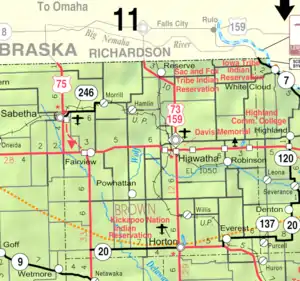 KDOT map of Brown County (legend) | |
 Kickapoo Site 5  Kickapoo Site 5 | |
| Coordinates: 39°40′20″N 95°40′56″W | |
| Country | United States |
| State | Kansas |
| County | Brown |
| Area | |
| • Total | 0.7 sq mi (1.9 km2) |
| • Land | 0.7 sq mi (1.9 km2) |
| • Water | 0.0 sq mi (0.0 km2) |
| Elevation | 1,040 ft (320 m) |
| Population (2010) | |
| • Total | 66 |
| • Density | 88/sq mi (34.0/km2) |
| Time zone | UTC-6 (CST) |
| • Summer (DST) | UTC-5 (CDT) |
| Area code | 785 |
| FIPS code | 20-36739 |
| GNIS ID | 2583502[1] |
Geography
Kickapoo Site 5 is located in southwest Brown County in the southwestern part of the Kickapoo Reservation. It is 9 miles (14 km) west of Horton. According to the United States Census Bureau, the CDP has a total area of 0.73 square miles (1.9 km2), all land.[2]
Demographics
For statistical purposes, the United States Census Bureau has defined this community as a census-designated place (CDP).
References
- U.S. Geological Survey Geographic Names Information System: Kickapoo Site 5, Kansas
- "Geographic Identifiers: 2010 Demographic Profile Data (G001): Kickapoo Site 5 CDP, Kansas". U.S. Census Bureau, American Factfinder. Archived from the original on February 12, 2020. Retrieved November 18, 2013.
Further reading
External links
- Kansas Kickapoo Tribe official website
- Brown County maps: Current, Historic, KDOT
Municipalities and communities of Brown County, Kansas, United States | ||
|---|---|---|
| Cities | 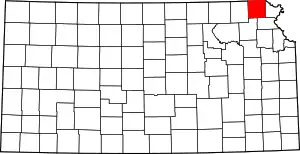 Map of Kansas highlighting Brown County | |
| Unincorporated communities | ||
| Indian reservations | ||
| Townships | ||
| Footnotes | †This community is designated a Census-Designated Place (CDP) by the United States Census Bureau. ‡This community also has portions in an adjacent county or counties. | |
| ||
This article is issued from Wikipedia. The text is licensed under Creative Commons - Attribution - Sharealike. Additional terms may apply for the media files.