Kamareddy district
Kamareddy district is a district located in the northern region of the Indian state of Telangana.[2][3] The district shares boundaries with Medak, Nizamabad, Sangareddy, Siddipet and Rajanna Sircilla districts and with the state boundary of Maharashtra and Karnataka.
Kamareddy district | |
|---|---|
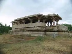 Temple at Domakonda fort | |
Location in Telangana | |
| Country | |
| State | Telangana |
| Headquarters | Kamareddy |
| Government | |
| • District Collector | Shri Dr. A Sharath |
| • Lok Sabha constituencies | 1 |
| Area | |
| • Total | 3,652 km2 (1,410 sq mi) |
| Population (2011) | |
| • Total | 974,227 |
| • Density | 270/km2 (690/sq mi) |
| Demographics | |
| • Literacy | 56.51 |
| • Sex ratio | 1033 |
| Time zone | UTC+05:30 (IST) |
| Vehicle registration | TS–17[1] |
| Website | kamareddy |
Geography
The district is spread over an area of 3,652.00 square kilometres (1,410.05 sq mi) making it the 15th largest district in the state.[4] Kamareddy is bounded by Nizamabad district on North, Sircilla and Siddipet districts to the east respectively, it is bounded on South by Sangareddy district and Medak district and on the West and South West by Nanded district and Bidar district of Maharashtra and Karnataka states respectively.
Demographics
As of 2011 Census of India, the district has a population of 974,227. Kamareddy is the 15th most populous out of 31 districts of Telangana.[5][6] Scheduled Castes and Scheduled Tribes make up 15.77% and 8.41% of the population respectively.[5]
At the time of the 2011 census, 77.07% of the population spoke Telugu, 8.73% Urdu, 7.57% Lambadi, 3.89% Marathi and 3.23% Kannada as their first language.[7]
Administrative divisions
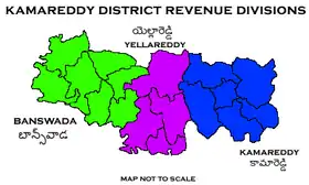
The district has three revenue divisions of Kamareddy and Banswada and Yellareddy are sub-divided into 22 mandals.[4][8] Dr. A. Sharath is the present collector of the district.[9]
See also
References
- "Telangana New Districts Names 2016 Pdf TS 31 Districts List". Timesalert.com. 11 October 2016. Retrieved 11 October 2016.
- "Kamareddy district" (PDF). Chief Commissioner of Land Administration. Archived from the original (PDF) on 9 September 2016. Retrieved 22 August 2016.
- "New districts map". newdistrictsformation.telangana.gov.in. Retrieved 22 August 2016.
- "New districts". Andhra Jyothy.com. 8 October 2016. Retrieved 8 October 2016.
- District census 2011: Nizamabadby mandals
- "Archived copy". Archived from the original on 8 July 2017. Retrieved 16 January 2017.
{{cite web}}: CS1 maint: archived copy as title (link) - 2011 Census of India, Population By Mother Tongue
- "Clipping of Andhra Jyothy Telugu Daily – Hyderabad". Andhra Jyothy. Retrieved 8 October 2016.
- "K Chandrasekhar Rao appoints collectors for new districts". Deccan Chronicle. 11 October 2016. Retrieved 13 October 2016.
External links
Places adjacent to Kamareddy district | |
|---|---|
| Topics | |
|---|---|
| Dynasties | |
| Districts |
|
| Commissionerates | |
| Major cities | |
| Tourism |
|
| Municipal corporations | |
| Related lists | |