Islands (regional unit)
The Islands Regional Unit (Greek: Περιφερειακή ενότητα Νήσων, Periphereiaki enotita Nison) is one of the regional units of Greece. It is part of the region of Attica. The regional unit covers the Saronic Islands, a small part of the Peloponnese peninsula, and a few islands off the eastern Peloponnese coast.
Islands
Περιφερειακή ενότητα Νήσων | |
|---|---|
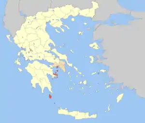 Islands regional unit within Attica | |
| Coordinates: 37°20′N 23°30′E | |
| Country | Greece |
| Region | Attica |
| Area | |
| • Total | 897.6 km2 (346.6 sq mi) |
| Population (2011) | |
| • Total | 74,651 |
| • Density | 83/km2 (220/sq mi) |
| Time zone | UTC+2 |
| • Summer (DST) | UTC+3 (EEST) |
Administrative History
The municipalities and provinces (except Troezen and Cythera which originally part of Argolis and Korinthos prefecture until 1925 and 1929 respectively, then part of Pefecture of Attica) which currently formed the regional unit of Islands was part of the Attica Prefecture and was created in 1833 as part of Attica and Boeotia Prefecture, then by 1964 to 1972 was part of the newly formed Piraeus Prefecture (Νομός) and after the abolishment of the Prefecture in 1972 again in Attica Prefecture as part of newly formed Piraeus Prefecture (Νομαρχία). As a part of the 2011 Kallikratis government reform the regional unit of Islands was created as part of the Region of Attica.
Administration
The regional unit of Islands was created as a part of the 2011 Kallikratis government reform. It is subdivided into 8 municipalities. These are:[1]
See also
References
Administrative division of the Attica Region | ||
|---|---|---|
| Regional unit of Central Athens | 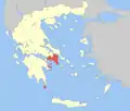 | |
| Regional unit of North Athens | ||
| Regional unit of West Athens | ||
| Regional unit of South Athens | ||
| Regional unit of Piraeus | ||
| Regional unit of East Attica | ||
| Regional unit of West Attica | ||
| Regional unit of Islands | ||