Interstate 74 in North Carolina
Interstate 74 (I-74) is a partially completed part of the Interstate Highway System that will eventually run from Davenport, Iowa, to Myrtle Beach, South Carolina. In the US state of North Carolina, I-74 currently exists in three distinct segments; from I-77 at the Virginia state line to U.S. Highway 52 (US 52) near Mount Airy, from I-40 in Winston-Salem to US 220 near Ellerbe, and from US 74 and US 74 Business (US 74 Bus.) near Maxton to US 74/North Carolina Highway 41 (NC 41) near Lumberton. I-74 has an extensive concurrency with I-73 from Randleman to Ellerbe in the Piedmont. When completed, I-74 will link the cities of Mount Airy, Winston-Salem, High Point, Rockingham, Laurinburg, and Lumberton.
 | ||||
|---|---|---|---|---|
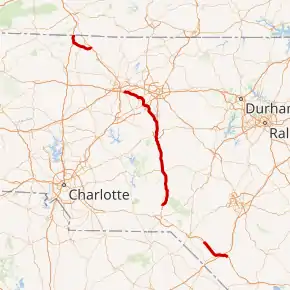 Open segments of I-74 as of March 2015 in red | ||||
| Route information | ||||
| Maintained by NCDOT | ||||
| Length | 124.91 mi[1][2][3][4] (201.02 km) | |||
| Existed | 1997–present | |||
| Major junctions | ||||
| West end | ||||
| East end | ||||
| Location | ||||
| Country | United States | |||
| State | North Carolina | |||
| Counties | Surry; Forsyth, Guilford, Randolph, Montgomery, Richmond; Robeson | |||
| Highway system | ||||
| ||||
The Intermodal Surface Transportation Efficiency Act of 1991 (ISTEA) authorized a new high priority transportation corridor from Michigan to Myrtle Beach, originally to be I-73. Conflicts over the routing of I-73 led to a compromise in 1995 that created a proposed extension of I-74 from Cincinnati, Ohio, to Myrtle Beach. The first section of I-74 was completed on August 27, 1996, between Steeds and Ulah. I-74 replaced North Carolina Highway 752 (NC 752) in 1998 near Mount Airy, and the entirety of the Mount Airy segment was completed by 2000. A segment of the Interstate was opened in 2008 between Maxton and Lumberton, creating the third segment of I-74 in North Carolina. In 2012, I-74 was extended from Ellerbe to Winston-Salem along US 311. The Piedmont segment was extended south in June 2013 and June 2018 in concurrency with I-73 and US 220 to Randleman.
Route description
As of September 27, 2018, there are a total of 124.91 miles (201.02 km) of I-74, broken in three segments across the state: Mount Airy, the Piedmont Triad, and Laurinburg areas.[5]
Mount Airy
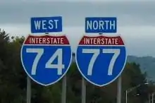
The first section of I-74 begins at the Virginia state line (overlapped with I-77 for approximately four miles [6.4 km]). After separation, it goes east and connects to US 52 near Mount Airy, where the first section ends.
I-74 is to be routed along US 52 from Mount Airy to Bethania, where it will then separate onto the new Winston-Salem Northern Beltway and go east around Winston-Salem before connecting to existing I-74 south of Kernersville. Under a new accelerated construction plan for the Beltway, right-of-way acquisition began in 2012 and construction started in December 2014. Until construction is completed, travelers wanting to connect between the first and second section of I-74 should stay on US 52 through downtown Winston-Salem and then take I-40 east to I-74 east toward High Point.[6]
Piedmont Triad
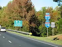
The second section of I-74 extends from the intersection with I-40 in southeastern Winston-Salem to High Point. Until January 2019, this section of I-74 was concurrent with US 311. This section was designated despite not having 10-foot (3.0 m) shoulders, with the promise that shoulders would be widened later. Signs were installed by August 2014. This section connects directly to another section,[7] called the High Point East Belt. It connects High Point with both I-85 Bus. and I-85. Construction completed on June 7, 2013, extended the freeway an additional eight miles (13 km) to US 220/I-73 at milemarker 86 in Randleman. The highway was originally to be completed by October 2012.[8]
I-74 joins with I-73/US 220 south in Randleman going south to Asheboro. The freeway is already completed but was not allowed to be signed as a full Interstate until the segment through Asheboro was upgraded to Interstate Highway standards in December 2013. The fourth section of I-74 (and I-73) starts along a bypass of Asheboro where a project to improve US 220 to Interstate standards was completed, and Interstate signs went up in 2012.[7][9]
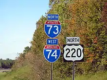
I-74 continues concurrently with I-73 and US 220 between I-73 milemarkers 68–42 (26 miles (42 km)), the first section marked as I-74 (and I-73) in North Carolina in 1997. It continues south, bypassing the towns of Seagrove, Biscoe, and Candor. Visitor centers (completed in 2010) are located eastbound and westbound at milemarker 61.[10] After exit 41, US 220 leaves the freeway and the route continues as I-73/I-74 for another 16 miles (26 km) toward Rockingham. Though this part of I-73/I-74 was completed in 2008 and is up to Interstate standards, it was initially signed as a future Interstate route because it had not been accepted into the Interstate Highway System by the Federal Highway Administration (FHWA) by the time it was opened, necessitating the posting of future shields. This situation was remedied on July 7, 2011, when the FHWA approved the addition of this segment to the Interstate Highway System.[11] The route was finally signed as I-73 and I-74 in the fall of 2013.
In late 2018, this segment was extended by 2.91 miles (4.68 km), from US 220/Haywood Cemetery Road to a partially completed trumpet interchange on US 220 north of Rockingham. A bypass under construction will extend this stretch to the US 74 bypass south of Rockingham.
Sandhills
At Rockingham, Future I-73 and I-74 will separate from current US 220 along a to-be-built bypass around the west of the city and then join the existing US 74 bypass freeway, which goes south around Rockingham and Hamlet. The first section of the bypass, four miles (6.4 km) of upgraded US 220, is under construction with a planned completion date of March 2018. Future I-73 ends near the NC 38 exit where it is planned to be routed south into South Carolina. Future I-74 continues to the end of the freeway. Between Hamlet and Laurinburg is an at-grade expressway that will eventually be upgraded to Interstate standards. At Laurinburg, I-74 is to use the Laurinburg Bypass that was at the standard North Carolina freeway grade and signed as I-74 in 2008; however, the North Carolina Department of Transportation (NCDOT) had to remove the signage the following year when the FHWA ruled against using them until the freeway was up to Interstate standards.
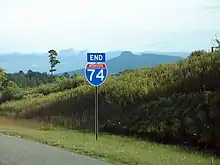
The third section of I-74 is officially named the American Indian Highway; completed in 2008, this 19-mile (31 km) section stretches from Maxton to south of Lumberton, connecting with I-95/US 301.[12] After NC 41, I-74 ends for the final time as the highway continues on as an at-grade expressway signed as US 74/Future I-74 Corridor.
East of I-95
.jpg.webp)
Future I-74 is to continue to follow US 74, going through the city of Whiteville and bypassing the town of Lake Waccamaw. While there are no funded projects to upgrade the entire highway to Interstate standards, NCDOT is funding several smaller projects to replace intersections with interchanges for several of the remaining cross streets, including for NC 72/NC 130 north of Boardman, and replacing other intersections with grade separations, such as with Old US 74 near Evergreen, over the next 10 years. Before the town of Bolton, it will separate from US 74 onto a proposed new freeway toward Shallotte, then go west on the proposed extension of South Carolina Highway 31 (SC 31, Carolina Bays Parkway) into South Carolina. This entire section of I-74 is still under a feasibility study with several possible routing options; it thus may take years before reaching South Carolina. Current NCDOT plans suggest that construction may not begin until after 2020 and that this will likely be the last section of I-74 to be completed.[13][14]
An interchange at Boardman Road has begun construction starting May 25, 2021, and is scheduled for completion in 2024. Another interchange at NC 72/NC 130 is due to start in 2022. A third project, now combined, would build an interchange at Chauncey Town Road (SR 1735) and a overpass at Old Lake Road (SR 1740) starting in 2025 for an estimated cost of $30 million for both projects. This would almost build a completed freeway to the NC 211 interchange in Bolton with two exceptions: an at-grade intersection at US 74/Creek Road (SR 2225) that would need to be closed and one minor crossing that would be deleted.
Alternate names
Though the highway is commonly known as I-74 throughout the state, the highway does have other known names it uses locally in areas.
- American Indian Highway—official name of the 19-mile (31 km) section of I-74 in Robeson County (milemarkers 191–213). It is named to honor the large American Indian population in Robeson County.[12]
- Blue Star Memorial Highway—unofficial North Carolina honorary name of I-74 in Randolph County (dedicated on June 7, 2013).[15][16]
- High Point East Belt—road name in Guilford County.
History
ISTEA initially authorized the new high priority transportation corridor 5, tentatively known as I-73, to travel from Michigan to South Carolina. Because of several disputes to the routing, a compromise was reached in 1995, by Senator John Warner and Senator Lauch Faircloth, that extended I-74 from its then current eastern terminus of Cincinnati to overlap I-73. (Original plans called for I-73 to run through Winston-Salem and Mount Airy, but, when its alignment was shifted to serve Greensboro, North Carolina, instead, this compromise resulted in I-74 using the Winston-Salem to Mount Airy route.) In Virginia, I-74 would follow I-77 into North Carolina, while I-73 would go east to Roanoke then south along US 220 toward Greensboro.[17][18][19] However, when I-73 crossed a border between two states, the federal law authorizing the road required that the two states agree that their sections meet. Originally, both Carolinas selected a route running south from Rockingham. North Carolina had more money to spend on roads, though,[20] and, on May 10, 1995, the US Senate Environment and Public Works Committee approved North Carolina's plan for I-73 to run eastward to the coast and enter South Carolina at North Myrtle Beach, South Carolina.[21] Another compromise, between Senator Lauch Faircloth and Senator Strom Thurmond, agreed to have both Interstates enter South Carolina: I-73 south of Rockingham and I-74 south of Wilmington, North Carolina.[22][23] After later amendments and the Transportation Equity Act for the 21st Century of 1998 (TEA-21), on July 25, 1998, the American Association of State Highway and Transportation Officials (AASHTO) accepted I-73/I-74 into the Interstate Highway System within the states of South Carolina, North Carolina, and Virginia.
The 12.6-mile (20.3 km) portion from south of Steeds north to south of Ulah was completed August 27, 1996, and was the first road marked as I-74 (and I-73).[24] Future signage was also installed north to the Greensboro area.[25] The remainder of the 26 miles (42 km) of existing and new freeway between Ulah and Candor was also signed as I-73/I-74 along US 220. In 1998, NC 752, a freeway spur of I-77 was renumbered as the segment of completed I-74, from I-77 to US 601. On June 30, 1999, the freeway was extended an additional five miles (8.0 km) to US 52, south of Mount Airy. In April 2001, I-74 was overlapped with I-77 from the Virginia state line to exit 101.
In January 2008, a 16.8-mile (27.0 km) section of freeway was completed from Candor to Ellerbe; however, it was signed Future I-73/I-74.[26] On November 22, 2010, a 14-mile (23 km) section (known as the East Belt) was added between North Main Street in High Point to Cedar Square Road near Glenola. This also includes the 6.4-mile (10.3 km) section of new freeway that opened between I-85 Business Cedar Square Road.[27] On October 4, 2012, I-74 was extended west from High Point to I-40, in Winston-Salem.[28]
On June 7, 2013, I-74 extended eight miles (13 km) east onto new primary routing from Cedar Square Road to I-73/US 220, near Randleman. Continuing in concurrency with I-73/US 220, it now connects two segments of the Interstate from Winston-Salem to Candor.
American Indian Highway and Laurinburg Bypass
On September 26, 2008, a 19-mile (31 km) section of I-74/US 74 was opened between Maxton to NC 41 near Lumberton, known as the American Indian Highway. The Laurinburg Bypass was also resigned I-74/US 74 at the same time. By the middle of the following year, the Laurinburg Bypass was removed of its I-74 designation by NCDOT after a ruling from the FHWA (it was resigned as a Future I-74 Corridor). The reason was that the section, though a freeway by North Carolina standards, it was not up to Interstate standards. It was also at this same time that NCDOT fixed an exit number error along milemarkers 181–191.
North Carolina Highway 752
North Carolina Highway 752 | |
|---|---|
| Location | Pine Ridge, North Carolina |
| Length | 1.0 mi[29] (1.6 km) |
| Existed | 1994–1998 |
North Carolina Highway 752 (NC 752) was the designation of the four-lane limited-access highway that traversed from I-77 to NC 89, near Pine Ridge. Established in 1994, it was a one-mile (1.6 km) freeway spur. In 1998, the freeway was extended to US 601 and was renumbered as I-74. Its short four-year existence was simply to be a placeholder for I-74.
Future
From Mount Airy to Rural Hall, US 52 is planned to be upgraded to Interstate standards. However, it is currently flagged "Scheduled for Reprioritization", with no estimated cost or date established.[30]
The section from Rockingham–Hamlet Bypass to Laurinburg Bypass is planned to be upgraded to Interstate standards. However, it is currently flagged "Scheduled for Reprioritization", with no estimated cost or date established.[31] When this section opened, it was signed "Future I-74", but those signs were taken down in late 2016.
A proposed new freeway in Columbus and Brunswick counties would traverse from Whiteville to the SC 31 in South Carolina. However, it is currently flagged "Scheduled for Reprioritization," with no estimated cost or date established.[13][14][32][33]
Winston-Salem Northern Beltway
North Carolina Highway 74 | |
|---|---|
| Location | Winston-Salem, North Carolina |
| Length | 5.5 mi (8.9 km) |
| Existed | 2020–present |
The Winston-Salem Northern Beltway is an under construction freeway loop around the North Carolina city of Winston-Salem. The western section has been designated as NC 452, which will later become I-274 when completed, and the eastern section of the beltway is designated as NC 74, which will later become part of I-74 when completed.[34][35]
On September 7, 2011, North Carolina Governor Bev Perdue announced that construction of a part of the eastern leg of the beltway would begin in 2014. The section to be built connects US 158 to I-40 Bus. (now US 421/Salem Parkway). Right-of-way acquisition began in 2012 and cost $34 million (equivalent to $38.6 million in 2020[36]); construction was estimated to cost $156 million.[37][38] Construction on the segment, Project U-2579B; commenced in December 2014,[6][38] with an anticipated completion date of November 2018. However, after delays, including an opening date of late 2019,[35] it was finally opened to traffic on September 5, 2020.[39]
Since then, funding has been allocated to complete the remaining sections of NC 74 between US 52 and the current I-74 (formerly cosigned with US 311), starting with the segment between US 311 and US 158, known as Project U-2579C; in October 2017. Construction on this segment began in 2018, this section has since opened to traffic effective December 23, 2020.[40]
That same year, a contract for the segment between NC 66 and US 311, Projects U-2579D, U-2579E, and U-2579F; was awarded. Actual construction began April 2019 and is scheduled to be completed in September 2021.[40][35] Next, construction on the segments between I-74 and US 421/Salem Parkway, Projects U-2579AA and U-2579AB; are scheduled to begin in 2020[40][6] and will open in 2024.[35] Construction on the interchange with US 52, which began in 2019,[41] is scheduled to be completed in September 2022.[35]
Rockingham bypass
A western bypass of Rockingham is planned, beginning at the partially-built trumpet interchange with US 220 where I-73 and I-74 currently end and running southwest to the trumpet interchange between US 74 and US 74 Bus., which will be reconfigured to accommodate the new bypass. Construction was initially scheduled for 2026 but was rescheduled for late 2019 and is planned to last three years, costing $146.1 million.[42][43] Upon completion of the bypass, I-74 will be designated along its length and along US 74 around Rockingham and Hamlet, terminating east of Hamlet at US 74 Bus.[44] The bypass will also carry I-73, which will terminate at the interchange with US 74 west of Rockingham until the section of I-73 extending into South Carolina is completed.[44]
Exit list
| County | Location | mi | km | Exit | Destinations | Notes | |
|---|---|---|---|---|---|---|---|
| Surry | | 0.0 | 0.0 | Western terminus of I-74 at the Virginia state line | |||
| Pine Ridge | 5.0 | 8.0 | 5 | South end of I-77 overlap | |||
| 5.6 | 9.0 | 6 | |||||
| | 7.8 | 12.6 | 8 | Red Brush Road | |||
| Mount Airy | 11.0 | 17.7 | 11 | ||||
| 13.0 | 20.9 | 13 | Park Drive | ||||
| 17.0 | 27.4 | 17 | |||||
| Route transition from I-74 to Future I-74 | |||||||
| | Cook School Road | Existing interchanges of US 52 (upgrade to Interstate standards, unfunded)[45] | |||||
| | West Main Street – Pilot Mountain | ||||||
| Pilot Mountain | |||||||
| | Pilot Knob Park Road – Pilot Mountain State Park | ||||||
| Stokes | | Perch Road – Pinnacle | |||||
| Forsyth | King | South Main Street – King, Tobaccoville | |||||
| Moore-RJR Drive | |||||||
| Rural Hall | Westinghouse Road | ||||||
| 41A | Completion scheduled for October 2019 (preliminary work for Northern Beltway project)[6][46] | ||||||
| Bethania | 41B | Under construction (completion scheduled for September 2022) | |||||
| Winston-Salem | 42 | Under construction (completion scheduled for September 2021)[6][41][46] | |||||
| 43 | |||||||
| 45 | Baux Mountain Road | ||||||
| Walkertown | 49 | Segment currently designated as NC 74, opened on December 23, 2020 | |||||
| 50 | Segment currently designated as NC 74, opened on September 5, 2020[6][46][39] | ||||||
| Kernersville | 53 | ||||||
| | 55 | Kernersville Road | Future interchanges (Construction to start in Spring 2022 with a completion date of November 2026) | ||||
| Winston-Salem | 56 | ||||||
| 55.2 | 88.8 | Route transition from Future I-74 to I-74 | |||||
| 55 | Temporary designation of I-74, future NC 192 | ||||||
| 56.6 | 91.1 | 56 | Ridgewood Road | ||||
| Union Cross | 57 | Future interchange | |||||
| 58.9 | 94.8 | 59 | Union Cross Road | ||||
| | 60.3 | 97.0 | 60 | High Point Road | |||
| Horneytown | 63.0 | 101.4 | 63 | ||||
| Guilford | High Point | 65.0 | 104.6 | 65 | North Main Street | ||
| 66.4 | 106.9 | 66 | Johnson Street | ||||
| 67.4 | 108.5 | 67 | To Piedmont Triad International Airport and High Point University | ||||
| 69.0 | 111.0 | 69 | Greensboro Road | ||||
| 70.3 | 113.1 | 70 | Martin Luther King Jr. Drive | Formerly named Kivett Drive[47] | |||
| 71.1 | 114.4 | 71A | East Green Drive | ||||
| 71.7 | 115.4 | 71B | |||||
| Archdale | 75.2 | 121.0 | 75 | ||||
| Randolph | Glenola | 79.4 | 127.8 | 79 | Cedar Square Road | ||
| Sophia | 84.0 | 135.2 | 84 | Old US Highway 311 | |||
| Randleman | 86.8 | 139.7 | 86 | North end of I-73/US 220 overlap; eastbound left exit | |||
| Asheboro | 87.9 | 141.5 | 79 | Pineview Street | |||
| 89.3 | 143.7 | 77 | Spero Road | ||||
| 90.7 | 146.0 | 76 | |||||
| 91.5 | 147.3 | 75 | Presnell Street | ||||
| 92.4 | 148.7 | 74 | Left exit; western terminus of NC 42 | ||||
| 94.0 | 151.3 | 72 A-B | A: B: | To North Carolina Zoo | |||
| 95.1 | 153.0 | 71 | McDowell Road | ||||
| | 70 | ||||||
| | 98.7 | 158.8 | 68 | To US 220 Alt | |||
| | 100.9 | 162.4 | 65 | New Hope Church Road | To North Carolina Zoo | ||
| Seagrove | 105.1 | 169.1 | 61 | ||||
| | 108.4 | 174.5 | 58 | Black Ankle Road | |||
| Montgomery | Ether | 111.1 | 178.8 | 56 | |||
| Star | 114.2 | 183.8 | 52 | Spies Road – Star, Robbins | |||
| Biscoe | 117.4 | 188.9 | 49 | ||||
| Candor | 122.4 | 197.0 | 44 | ||||
| Emery | 125.5 | 202.0 | 41 | South end of US 220 overlap | |||
| | 127.4 | 205.0 | 39 | Tabernacle Church Road | |||
| Richmond | Norman | 131.4 | 211.5 | 35 | Moore Street – Norman | ||
| | 133.2 | 214.4 | 33 | ||||
| | 136.5 | 219.7 | 30 | Haywood Parker Road | |||
| Ellerbe | 138.8 | 223.4 | 28 | ||||
| | 141.5 | 227.7 | 25 | ||||
| | 23 | Dockery Road / Haywood Cemetery Road | |||||
| | 22 | Partial interchange (rest to be constructed by 2023)[48] | |||||
| | Route transition from I-74 to Future I-74 | ||||||
| | 16 | Future interchange (funded)[48] | |||||
| | 15 | Galestown Road – Cordova | Existing interchanges of US 74 | ||||
| | |||||||
| | |||||||
| | |||||||
| | Future interchange (unfunded)[49][50] | ||||||
| | Existing interchanges of US 74[31] | ||||||
| | |||||||
| Scotland | Laurel Hill | Existing interchanges of US 74 (upgrade to Interstate standards, unfunded)[31] | |||||
| | 180.4 | 290.3 | 181 | ||||
| | 181.2 | 291.6 | 182 | ||||
| Laurinburg | 182.8 | 294.2 | 183 | Existing interchanges of US 74 / US 501 (upgrade to Interstate standards, unfunded) | |||
| 183.2 | 294.8 | 184 | |||||
| 184.1 | 296.3 | 185 | |||||
| | 185.8 | 299.0 | 186 | Existing interchanges of US 74 (upgrade to Interstate standards, unfunded) | |||
| | 186.6 | 300.3 | 187 | ||||
| | 189.4 | 304.8 | 190 | Airport Road – Laurinburg–Maxton Airport, Maxton | |||
| Robeson | Maxton | 190.8 | 307.1 | 191 | |||
| 194.0 | 312.2 | Route transition from Future I-74 to I-74 | |||||
| 194 | Signed as 194A (west) and 194B (east) | ||||||
| | 197.0 | 317.0 | 197 | Cabinet Shop Road | |||
| | 200.7 | 323.0 | 200 | ||||
| | 203.9 | 328.1 | 203 | Dew Road – Pembroke | |||
| | 207.9 | 334.6 | 207 | Back Swamp Road | |||
| Lumberton | 209.3 | 336.8 | 209 | Signed as 209A (south) and 209B (north) | |||
| 210.5 | 338.8 | 210 | |||||
| 213.1 | 343.0 | 213 | |||||
| 213.6 | 343.8 | Route transition from I-74 to Future I-74 | |||||
| | 219.4 | 353.1 | 219 | Broadridge Road (SR 2220) | Completed November 2019; not currently signed as I-74 | ||
| | 222 | Project scheduled to be let January 2023 | |||||
| Columbus | Boardman | 225 | Old Boardman Road (SR 1506) | Contract was awarded April 20, 2021 (was rescheduled from 2025 start). Interchange construction has started effective May 25, 2021 (completion scheduled for February 2025). | |||
| Evergreen | 228.9 | 368.4 | 228 | Current interchanges of US 74 (upgrade to Interstate standards, unfunded)[13][14] | |||
| Chadbourn | 233.7 | 376.1 | 233 | ||||
| 235.7 | 379.3 | 235 | Existing interchanges of US 74 / US 76 (upgrade to Interstate standards, unfunded)[13][14] | ||||
| | 238.5 | 383.8 | 238 | Union Valley Road | |||
| Whiteville | 241.4 | 388.5 | 241 | ||||
| 244.3 | 393.2 | 244 | |||||
| Hallsboro | 248.0 | 399.1 | 248 | Hallsboro Road (SR 1001) | Opened to traffic June 12, 2020; not currently signed as I-74 | ||
| Lake Waccamaw | 252.4 | 406.2 | 252 | Chauncey Town Road (SR 1735) | Project scheduled to be let July 2022 | ||
| | 253.7 | 408.3 | 253 | Old Lake Road (SR 1740) | Project scheduled to be let July 2022 (this intersection and one above were separated previously. Both were due to start in 2025.) | ||
| Bolton | 258.4 | 415.9 | 258 | Last exit with I-74 exit number on US 74 | |||
| Proposed Interstate 74 corridor from US 74/US 76 to US 17/South Carolina state line (route unconfirmed).[13][14][32][33] | |||||||
1.000 mi = 1.609 km; 1.000 km = 0.621 mi
| |||||||
See also
 U.S. Roads portal
References
- Federal Highway Administration (October 31, 2002). "Table 1: Main Routes of the Dwight D. Eisenhower National System of Interstate and Defense Highways as of October 31, 2002". Route Log and Finder List. Federal Highway Administration. Retrieved August 29, 2012.
- Google (February 14, 2013). "Interstate 74 (Mount Airy Segment)" (Map). Google Maps. Google. Retrieved February 14, 2013.
- Google (October 26, 2013). "Interstate 74 (Piedmont Triad Segment)" (Map). Google Maps. Google. Retrieved October 26, 2013.
- Google (February 14, 2013). "Interstate 74 (Laurinburg Segment)" (Map). Google Maps. Google. Retrieved February 14, 2013.
- North Carolina Department of Transportation. Proposed I-73 and I-74 Routes (PDF) (Map). North Carolina Department of Transportation. Retrieved May 12, 2014.
- North Carolina Department of Transportation. "Winston-Salem Northern Beltway". North Carolina Department of Transportation. Archived from the original on October 6, 2011. Retrieved November 26, 2011.
- Wesley Young (March 4, 2013). "Road to the Future". Winston-Salem Journal. p. A4.
- "I-74/US 311 Connector Expected to Open on Friday". MyFox8.com. June 4, 2013.
- North Carolina Department of Transportation. "Contract C202472". NCDOT Construction Progress Report. North Carolina Department of Transportation. Retrieved June 4, 2013.
- North Carolina Department of Transportation. "North Carolina Rest Area System". North Carolina Department of Transportation. Retrieved January 27, 2011.
- Mendez, Victor M. (July 7, 2011). "Letter to Terry R. Gibson, P.E., State Highway Administrator, North Carolina Department of Transportation" (PDF). Federal Highway Administration. Retrieved August 11, 2012.
- North Carolina Department of Transportation (November 18, 2010). "I-74 'The American Indian Highway' Naming Ceremony" (Press release). North Carolina Department of Transportation. Archived from the original on December 25, 2012. Retrieved December 31, 2010.
- North Carolina Department of Transportation. "I-74 Feasibility Study". North Carolina Department of Transportation. Archived from the original on June 5, 2013. Retrieved August 27, 2012.
- I-74 Feasibility Map (PDF) (Map). North Carolina Department of Transportation. Retrieved August 27, 2012.
- "NCDOT: NC Blue Star Memorial Marker Locations". Archived from the original on May 22, 2011. Retrieved June 7, 2013.
- North Carolina Department of Transportation. "Final Section of US 311 Bypass Opens in Randolph County". North Carolina Department of Transportation. Retrieved June 7, 2013.
- Lounsbury, Helen (November 11, 1993). "Road to Roanoke Vital, Group Says Lobbying for New Interstate". News & Record. Greensboro, North Carolina. p. B3. ISSN 0747-1858.
- Catanoso, Justin (April 14, 1995). "New Proposal for I-73 Stirs Triad Rivalry". News & Record. Greensboro, NC. p. B1. ISSN 0747-1858.
- Catanoso, Justin (May 2, 1995). "New Interstates May Cross Triad". News & Record. Greensboro, North Carolina. p. A1. ISSN 0747-1858.
- Monk, John (April 11, 1995). "Despite S.C. Objections, N.C. Prepares I-73 Link". The State. Columbia, SC. p. B5.
- Pope, Charles (May 11, 1995). "I-73 Rolls Through Angry Thurmond's Roadblocks". The State. Columbia, SC. p. B1.
- Soraghan, Mike (June 17, 1995). "Carolinas Make a Deal on Routes of New Interstates". The State. Columbia, SC. p. B5.
- Porter, Arlie (June 4, 1995). "I-73: Paved with good intentions?". Post and Courier. Charleston, SC. p. A23.
- McKay, Rich (August 28, 1996). "US 220 Widened Near Seagrove". News & Record. Greensboro, North Carolina. p. B2. ISSN 0747-1858.
- Hall, Tony (March 28, 1997). "State Making Good Progress on Interstates". News & Record. Greensboro, North Carolina. p. B2. ISSN 0747-1858.
- MacCallum, Tom (January 8, 2008). "Ellerbe Bypass Opens After Years of Construction". Richmond County Daily Journal. Rockingham, North Carolina.
- North Carolina Department of Transportation (November 22, 2010). "NCDOT Opens I-74/US 311 Bypass Near High Point" (Press release). North Carolina Department of Transportation. Retrieved December 31, 2010.
- North Carolina Department of Transportation (October 4, 2012). "I-74 Route Change (2012-10-04)" (PDF). North Carolina Department of Transportation. Retrieved February 14, 2013.
- Google (June 9, 2013). "North Carolina Highway 752" (Map). Google Maps. Google. Retrieved June 9, 2013.
- North Carolina Department of Transportation. "Project I-4404". Project Details. North Carolina Department of Transportation. Archived from the original on January 9, 2012. Retrieved January 22, 2012.
- North Carolina Department of Transportation. "Project I-3801". Project Details. North Carolina Department of Transportation. Archived from the original on October 29, 2011. Retrieved January 22, 2012.
- North Carolina Department of Transportation. "Project R-3436". Project Details. North Carolina Department of Transportation. Archived from the original on October 29, 2011. Retrieved August 27, 2012.
- North Carolina Department of Transportation. "Carolina Bays Parkway". Project Details. North Carolina Department of Transportation. Archived from the original on October 29, 2011. Retrieved August 27, 2012.
- "Route Change (1999-03-26)" (PDF). North Carolina Department of Transportation. March 26, 1999. Retrieved June 20, 2014.
- Young, Wesley (July 27, 2019). "First beltway segment opens this fall". Winston-Salem Journal. Retrieved December 27, 2019.
- Johnston, Louis; Williamson, Samuel H. (2022). "What Was the U.S. GDP Then?". MeasuringWorth. Retrieved February 12, 2022. United States Gross Domestic Product deflator figures follow the Measuring Worth series.
- North Carolina Department of Transportation. "Winston-Salem Northern Beltway". North Carolina Department of Transportation. Archived from the original on October 6, 2011. Retrieved November 26, 2011.
- Garber, Paul (September 7, 2011). "Construction of first segment of Northern Beltway will begin in 2014, governor says". Winston-Salem Journal. Retrieved January 22, 2012.
- Young, Wesley (September 4, 2020). "6 new lanes, all 65 mph opening from Salem Parkway to Reidsville Road". Winston-Salem Journal. Retrieved September 5, 2020.
- Young, Wesley (April 5, 2018). "Three new Northern Beltway segments in Forsyth County under contract". Winston-Salem Journal. Retrieved December 27, 2019.
- Young, Wesley (September 29, 2018). "Work starts next year on Beltway interchange with U.S. 52". Winston-Salem Journal. Retrieved January 23, 2019.
- Stone, Gavin (January 10, 2019). "Bypass project around Rockingham accelerated from 2026 to 2020". Richmond County Daily Journal. Retrieved November 7, 2019.
- North Carolina Department of Transportation (November 5, 2019). "NCDOT Awards Contract for Rockingham Bypass" (Press release). North Carolina Department of Transportation. Retrieved December 27, 2019.
- "Signing Plans 2" (PDF). North Carolina Department of Transportation. July 5, 2019. Retrieved December 27, 2018.
- North Carolina Department of Transportation. "Project #I-4404". Project Details. North Carolina Department of Transportation. Archived from the original on October 29, 2011. Retrieved August 25, 2012.
- North Carolina Department of Transportation. "Project U-2579". Project Details. North Carolina Department of Transportation. Archived from the original on October 29, 2011. Retrieved August 27, 2012.
- "High Point's Kivett Drive to be renamed Martin Luther King Jr. Boulevard". Winston-Salem, North Carolina: WXII-TV. March 25, 2015. Retrieved December 9, 2015.
- North Carolina Department of Transportation. "Project #R-3421". Project Details. North Carolina Department of Transportation. Archived from the original on October 29, 2011. Retrieved June 7, 2013.
- I-73 Northern Map (PDF) (Map). North Carolina Department of Transportation. Wallace inset. Retrieved August 25, 2012.
- North Carolina Department of Transportation. "Project #I-4923". Project Details. North Carolina Department of Transportation. Archived from the original on October 29, 2011. Retrieved August 27, 2012.