Imphal West district
Imphal West district (Pron:/ˈɪmfəl or ɪmˈfɑːl/) is one of the sixteen districts of Manipur state in northeastern India. As of 2011 it is the most populous district in the state.[1]
Imphal West district | |
|---|---|
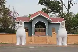 Entrance to Kangla Palace | |
Location in Manipur | |
| Coordinates: 24°49′N 93°54′E | |
| Country | |
| State | |
| Headquarters | Lamphelpat |
| Area | |
| • Total | 519 km2 (200 sq mi) |
| Population (2011) | |
| • Total | 517,992 |
| • Density | 1,000/km2 (2,600/sq mi) |
| Languages | |
| • Official | Meiteilon (Manipuri) |
| Time zone | UTC+5:30 (IST) |
| ISO 3166 code | IN-MN-WI |
| Vehicle registration | MN |
| Website | imphalwest |
Geography
Lamphelpat city is the administrative headquarters of the district. The district occupies an area of 519 km2.
| Imphal | ||||||||||||||||||||||||||||||||||||||||||||||||||||||||||||
|---|---|---|---|---|---|---|---|---|---|---|---|---|---|---|---|---|---|---|---|---|---|---|---|---|---|---|---|---|---|---|---|---|---|---|---|---|---|---|---|---|---|---|---|---|---|---|---|---|---|---|---|---|---|---|---|---|---|---|---|---|
| Climate chart (explanation) | ||||||||||||||||||||||||||||||||||||||||||||||||||||||||||||
| ||||||||||||||||||||||||||||||||||||||||||||||||||||||||||||
| ||||||||||||||||||||||||||||||||||||||||||||||||||||||||||||
Economy
The district ranks first on the basis of "District Infrastructure Index " calculated under the patronage of Department of Development of North Eastern Region.[2]
Demographics
According to the 2011 census Imphal West district has a population of 517,992,[1] roughly equal to the nation of Cape Verde.[4] This gives it a ranking of 545th in India (out of a total of 640).[1] The district has a population density of 992 inhabitants per square kilometre (2,570/sq mi) .[1] Its population growth rate over the decade 2001-2011 was 15.82%.[1] Imphal West has a sex ratio of 1029 females for every 1000 males,[1] and a literacy rate of 86.7%. Scheduled Castes and Scheduled Tribes make up 3.19% and 4.66% of the population respectively.[1]
Administrative divisions
The district is divided into 4 sub-divisions and 10 Circles:
- Lamphelpat Sub-Division: Lamphelpat
- Patsoi Sub-Division: Patsoi, Konthoujam
- Lamsang Sub-Division: Salam, Lamsang, Sekmai
- Wangoi Sub-Division: Hiyangthang, Lilong Chajing, Wangoi, Mayang Imphal
Areas under Imphal Urban Agglomeration
References
- "District Census 2011". Census2011.co.in. 2011. Retrieved 30 September 2011.
- "District at a glance". Imphal West district website. Archived from the original on 26 March 2010. Retrieved 19 May 2010.
- "Population by religious community - Manipur". Office of the Registrar General & Census Commissioner, India. 2011.
- US Directorate of Intelligence. "Country Comparison:Population". Retrieved 1 October 2011.
Cape Verde 516,100 July 2011 est.
- "Census of India Website : Office of the Registrar General & Census Commissioner, India".
External links
Places adjacent to Imphal West district | ||||||||||||||||
|---|---|---|---|---|---|---|---|---|---|---|---|---|---|---|---|---|
| ||||||||||||||||
| State symbols | |
|---|---|
| Topics | |
| Languages | |
| Administration | |
| Districts | |
| Municipal Corporation | |
| Municipalities | |
| Town Councils | |
| Minor Townships | |
| Sport | |