Ifarantsa
Ifarantsa is a town and commune in Madagascar. It belongs to the district of Taolanaro, which is a part of Anosy Region. The population of the commune was estimated to be approximately 10,000 in 2001 commune census.[2]
Ifarantsa | |
|---|---|
 Ifarantsa Location in Madagascar | |
| Coordinates: 24°56′S 46°51′E | |
| Country | |
| Region | Anosy |
| District | Taolanaro |
| Area | |
| • Land | 234 km2 (90 sq mi) |
| Elevation | 21 m (69 ft) |
| Population (2001)[2] | |
| • Total | 10,000 |
| Time zone | UTC3 (EAT) |
It is situated at 22 km from Fort Dauphin with which it is linked by the regional road 118.
Only primary schooling is available. The majority 70% of the population of the commune are farmers, while an additional 15% receives their livelihood from raising livestock. The most important crop is rice, while other important products are sugarcane and cassava. Industry and services provide employment for 4% and 10% of the population, respectively. Additionally fishing employs 1% of the population.[2]
Cash crops
In Ifrantsa Peppercorn trees are harvested.[3]
References
- Estimated based on DEM data from Shuttle Radar Topography Mission
- "ILO census data". Cornell University. 2002. Retrieved 2008-05-04.
- (in french) Ansosy vise 280 to Baies Roses
Capital: Fort Dauphin (Taolagnaro) | ||
| Amboasary Sud (14) - 603 | 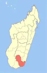 | |
| Betroka (20) - 613 | ||
| Taolagnaro (24) - 614 | ||
3 districts; 58 communes | ||