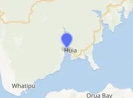
Huia, New Zealand
Huia is a western coastal settlement in West Auckland, New Zealand and forms part of the Waitākere Ranges Regional Park. The majority of houses in Huia are located along Huia Road, which arcs around Huia Bay and heads west towards Little Huia.
Huia | |
|---|---|
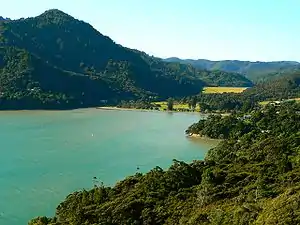 Looking north-west from Huia look-out over Huia bay towards the Lower Huia Dam. | |
 | |
| Coordinates: 36.999°S 174.569°E | |
| Country | New Zealand |
| City | Auckland Council |
| Electoral ward | Waitākere |
| Local board | Waitākere Ranges |
| Area | |
| • Land | 3.49 ha (8.62 acres) |
| Population (2018 Census)[2] | |
| • Total | 639 |
| (Waitākere Ranges) | (Waitākere Ranges) | Waitākere Ranges |
| Little Huia |
|
Cornwallis |
| Whatipu | (Manukau Harbour) | (Manukau Harbour) |
History
Huia was originally known as Te Huia as the area is thought to be named after a Māori chief, Te Huia, who stayed in the bay and was so taken by the area that he remained there.[3][4] The English translation "The Huia" was used into the 1970s, but simply "Huia" has now become more commonplace.[5] In the 1850s, the Karamatura Stream to the west of Huia was one of the first streams in the Waitākere Ranges to be dammed for kauri logging.[6] The nearby Marama and Kakamatua streams near Huia were similarly dammed in the 1860s, followed by the Huia Stream in the 1870s.[6]
Demographics
Huia is described by Statistics New Zealand as a rural settlement, and covers 3.49 km2 (1.35 sq mi).[1] It is part of the Waitākere Ranges South SA2 statistical area.[7]
| Year | Pop. | ±% p.a. |
|---|---|---|
| 2006 | 546 | — |
| 2013 | 588 | +1.06% |
| 2018 | 639 | +1.68% |
| Source: [2] | ||
Huia had a population of 639 at the 2018 New Zealand census, an increase of 51 people (8.7%) since the 2013 census, and an increase of 93 people (17.0%) since the 2006 census. There were 264 households. There were 315 males and 324 females, giving a sex ratio of 0.97 males per female, with 123 people (19.2%) aged under 15 years, 93 (14.6%) aged 15 to 29, 360 (56.3%) aged 30 to 64, and 69 (10.8%) aged 65 or older.
Ethnicities were 94.4% European/Pākehā, 19.7% Māori, 4.7% Pacific peoples, 3.3% Asian, and 0.9% other ethnicities (totals add to more than 100% since people could identify with multiple ethnicities).
Although some people objected to giving their religion, 70.4% had no religion, 19.2% were Christian, 0.9% were Buddhist and 2.8% had other religions.
Of those at least 15 years old, 141 (27.3%) people had a bachelor or higher degree, and 63 (12.2%) people had no formal qualifications. The employment status of those at least 15 was that 297 (57.6%) people were employed full-time, 78 (15.1%) were part-time, and 12 (2.3%) were unemployed.[2]
Features
The Huia Store, the sole local general store and cafe, opened in 1886.[8] Huia is also served by the Huia Volunteer Fire Brigade.
On the shores of Huia Bay is Huia Reserve, there are picnic tables, a BBQ, a small playground, basketball half-court and a half pipe for skating. It is close to the Lower Huia Dam, Upper Huia Dam and Karamatura Falls.
The Upper Huia Dam opened in 1929 and the Lower Huia Dam opened in 1971. Both reservoirs form part of the water supply for Auckland and are managed by Watercare Services.
The Auckland Council operates several accommodation facilities in the area including the Kiwanis Huia camp, Huia Lodge, Barr cottage (situated on the waterfront in Little Huia) and a camping area known as Barn Paddock in the Karamatura farm. Huia Lodge was the school house of Huia School between 1894 and 1961; the local state secondary school is Green Bay High School.[9]
Huia Settlers Museum, opened in 1984, is located near the entrance to the Karamatura Park. It contains many relics of the Kauri felling and milling and artefacts from the wreck of HMS Orpheus.[10][11]
Jonesonian Institute, a small eclectic museum and art gallery modelled on Museum of Jurassic Technology, is also located in Huia.[12]
There are an abundance of walking tracks around the Huia area and there are numerous camp sites in the Karamatura Valley. The highest point in the Waitākere Ranges - Te Toi o Kawharu (474m), accessible via the Twin Peaks Track, is part of this valley.
References
| Wikimedia Commons has media related to Huia (suburb). |
- "ArcGIS Web Application". statsnz.maps.arcgis.com. Retrieved 9 March 2022.
- "Statistical area 1 dataset for 2018 Census". Statistics New Zealand. March 2020. 7007108–7007110.
- Laing, N. (1985). "The settlement of the Huia: a history of the Huia and adjacent parts of the Manukau Harbour", Auckland.
- Reed, A.W. (2002). The Reed Dictionary of New Zealand place names, Reed Publishing, Auckland. ISBN 978-0-7900-0040-4.
- Laing, N. (1976). "Huia: an album from the past", Lodestar Press, Auckland.
- Hayward, B. W.; Diamond, J. T. (1975). "Kauri Dam Sites in the Waitakere Ranges" (PDF). Tane. 6: 105–120. Retrieved 3 May 2022.
- 2018 Census place summary: Waitākere Ranges South
- "Huia: Big adventure, little time". The New Zealand Herald. 30 March 2009. Retrieved 7 January 2012.
- "Our Parks: Huia". arc.govt.nz. Retrieved 5 June 2008.
- "Huia Settlers Museum".
- "Huia Settlers Museum on NZ Museums". nzmuseums.co.nz. Te Papa.
- "Jonesonian Institute on NZ Museums". nzmuseums.co.nz. Te Papa.
External links
- Photographs of Huia held in Auckland Libraries' heritage collections.