Hoteo River
The Hoteo River is a river of the Auckland Region of New Zealand. It flows southwest from its sources close to the North Auckland Peninsula's east coast before emptying into the southern lobe of the Kaipara Harbour.
| Hoteo River | |
|---|---|
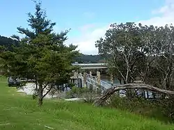 The Hoteo River as it reaches the Mangakura Inlet. | |
| Location | |
| Country | New Zealand |
| Physical characteristics | |
| Mouth | |
• location | Kaipara Harbour |
| Length | 28 km (17 mi) |
| Basin size | 405 km2 (156 sq mi) |
| Discharge | |
| • average | 11 m3/s (390 cu ft/s) |
The lower reaches of the river are popular with whitebaiters and recreational fishermen and the river also hosts the annual Hoteo River Raft Race, a no-holds-barred event.
State Highway 1 crosses the river at Wayby, south of Wellsford and State Highway 16 crosses the river near Mangakura where it discharges into the Kaipara Harbour.
The headwaters of the Hoteo River is the Waitapu Stream that starts within 5 km of the East Coast and the system drains out into the West Coast of Northland. The Hoteo forms at the confluence of the Whangaripo and Waiwhiu streams.[1]
The North Auckland Rail Line crosses the Hoteo river 3 times within 1.5 km; to the north of Kaipara Flats.
See also
References
"Place name detail: Hoteo River". New Zealand Gazetteer. New Zealand Geographic Board. Retrieved 14 June 2021.
- "Hoteo River Catchment: Environment and Socio-economic Review" (PDF). Auckland Council. August 2014.
{{cite web}}: CS1 maint: url-status (link)
External links
Photos -