Hochstadt am Main
Hochstadt am Main is a municipality in the district of Lichtenfels in Bavaria in Germany. It lies on the river Main.
Hochstadt a.Main | |
|---|---|
 Hospital in Hochstadt am Main | |
 Coat of arms | |
Location of Hochstadt a.Main within Lichtenfels district 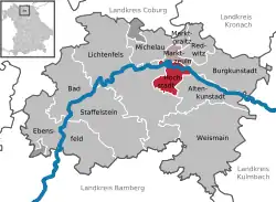 | |
 Hochstadt a.Main  Hochstadt a.Main | |
| Coordinates: 50°8′N 11°10′E | |
| Country | Germany |
| State | Bavaria |
| Admin. region | Oberfranken |
| District | Lichtenfels |
| Municipal assoc. | Hochstadt-Marktzeuln |
| Subdivisions | 7 Ortsteile |
| Government | |
| • Mayor (2020–26) | Max Zeulner[1] (CSU) |
| Area | |
| • Total | 13.79 km2 (5.32 sq mi) |
| Elevation | 281 m (922 ft) |
| Population (2020-12-31)[2] | |
| • Total | 1,617 |
| • Density | 120/km2 (300/sq mi) |
| Time zone | UTC+01:00 (CET) |
| • Summer (DST) | UTC+02:00 (CEST) |
| Postal codes | 96272 |
| Dialling codes | 09574 |
| Vehicle registration | LIF/STE |
| Website | www.hochstadt-main.de |
References
- Liste der ersten Bürgermeister/Oberbürgermeister in kreisangehörigen Gemeinden, Bayerisches Landesamt für Statistik, 15 July 2021.
- "Tabellenblatt "Daten 2", Statistischer Bericht A1200C 202041 Einwohnerzahlen der Gemeinden, Kreise und Regierungsbezirke". Bayerisches Landesamt für Statistik (in German). June 2021.
Towns and municipalities in Lichtenfels district | ||
|---|---|---|
Coat of Arms of Lichtenfels district | ||
This article is issued from Wikipedia. The text is licensed under Creative Commons - Attribution - Sharealike. Additional terms may apply for the media files.