Colbert County, Alabama
Colbert County (/ˈkɒlbərt/)[1] is a county located in the northwestern part of the U.S. state of Alabama. As of the 2020 census the county's population was 57,227.[2] The county seat is Tuscumbia.[3] The largest city is Muscle Shoals. The county is named in honor of brothers George and Levi Colbert, Chickasaw Indian chiefs.[4]
Colbert County | |
|---|---|
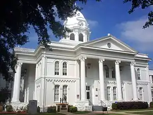 Colbert County Courthouse in Tuscumbia | |
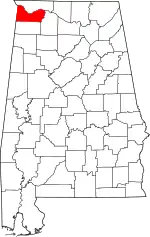 Location within the U.S. state of Alabama | |
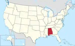 Alabama's location within the U.S. | |
| Coordinates: 34°40′36″N 87°49′02″W | |
| Country | |
| State | |
| Founded | February 6, 1867 |
| Named for | George and Levi Colbert |
| Seat | Tuscumbia |
| Largest city | Muscle Shoals |
| Area | |
| • Total | 622 sq mi (1,610 km2) |
| • Land | 593 sq mi (1,540 km2) |
| • Water | 30 sq mi (80 km2) 4.7% |
| Population (2020) | |
| • Total | 57,227 |
| • Estimate (2021) | 57,474 |
| • Density | 92/sq mi (36/km2) |
| Time zone | UTC−6 (Central) |
| • Summer (DST) | UTC−5 (CDT) |
| Congressional district | 4th |
| Website | www |
| |
Colbert County is part of the Florence-Muscle Shoals, AL Metropolitan Statistical Area, also known as "The Shoals".
History
Chickasaw and Cherokee Indians were the earliest inhabitants of Colbert County. In the 1810s, settlers began to settle in an area at a crossroads that came to be Leighton, AL. Colbert County was originally established on February 6, 1867, after it split from Franklin County over political issues after the American Civil War. It was abolished eight months later on November 29, 1867[5] by an Alabama constitutional convention and then reestablished on February 24, 1870. In 1890, the eastern boundary of Colbert County changed from County Line Road to Town Creek which resulted in all of Leighton placed within Colbert County.[4] Cobert County is the location of Ivy Green, the birthplace of noted author Helen Keller.[4] Colbert County includes the cities of Sheffield and Muscle Shoals where many popular musicians such as Aretha Franklin and the Rolling Stones recorded music. Also located in Colbert County is the Key Underwood Coon Dog Memorial Graveyard established in 1937.[6]
Geography
According to the United States Census Bureau, the county has a total area of 622 square miles (1,610 km2), of which 593 square miles (1,540 km2) is land and 30 square miles (78 km2) (4.7%) is water.[7] The county's elevation ranges from 410 feet at the Tennessee River in northwestern Colbert County to 980 feet in southeastern Colbert County at the broadcast facility's tower of WQPR-FM/WFIQ-TV.
National protected area
- Natchez Trace Parkway (part)
River
Major Creeks
- Bear Creek
- Cane Creek
- Mulberry Creek
- Spring Creek
- Town Creek
Waterfalls
- Cane Creek Canyon Waterfall
- Rainbow Branch Waterfall
- Wilson Dam Waterfall
Notable Springs
- Big Spring at Tuscumbia
- Buzzard Roost Spring at Margerum
- Chalybeate Spring at Littleville
- Milk Springs at Colbert Heights
- Shegog Spring at Ford City
Notable Mountains
- Bald Knob
- Coburn Mountain
- Colbert Mountain
- Hawk Pride Mountain
- LaGrange Mountain
- Mountain Mills Ridge
- Sand Mountain
- Underwood Mountain
- Wagnon Mountain
- Wheeler Mountain
Adjacent counties
- Lauderdale County - north
- Lawrence County, Alabama - southeast
- Franklin County, Alabama - south
- Tishomingo County, Mississippi - west
Transportation
Major highways
Rail
- Norfolk Southern Railway - freight lines going South, East, and West.[8]
Airports
- Big River Airpark
- Northwest Alabama Regional Airport
Demographics
| Historical population | |||
|---|---|---|---|
| Census | Pop. | %± | |
| 1870 | 12,537 | — | |
| 1880 | 16,153 | 28.8% | |
| 1890 | 20,189 | 25.0% | |
| 1900 | 22,341 | 10.7% | |
| 1910 | 24,802 | 11.0% | |
| 1920 | 31,997 | 29.0% | |
| 1930 | 29,860 | −6.7% | |
| 1940 | 34,093 | 14.2% | |
| 1950 | 39,561 | 16.0% | |
| 1960 | 46,506 | 17.6% | |
| 1970 | 49,632 | 6.7% | |
| 1980 | 54,519 | 9.8% | |
| 1990 | 51,666 | −5.2% | |
| 2000 | 54,984 | 6.4% | |
| 2010 | 54,428 | −1.0% | |
| 2020 | 57,227 | 5.1% | |
| 2021 (est.) | 57,474 | [9] | 5.6% |
| U.S. Decennial Census[10] 1790-1960[11] 1900-1990[12] 1990-2000[13] 2010-2020[2] | |||
2000
As of the census[14] of 2000, there were 54,984 people, 22,461 households, and 16,037 families residing in the county. The population density was 92 people per square mile (36/km2). There were 24,980 housing units at an average density of 42 per square mile (16/km2). The racial makeup of the county was 78.52% White or European American (non-Hispanic), 16.62% Black or African American, 0.37% Native American, 0.24% Asian, 0.02% Pacific Islander, 0.34% from other races, and 0.89% from two or more races. 1.12% of the population were Hispanic or Latino of any race.
2010
According to the 2010 United States Census Bureau:
- 80.4% White (non-Hispanic)
- 14.0% Black
- 0.4% Native American
- 0.7% Asian
- 0.0% Native Hawaiian or Pacific Islander
- 0.91% Two or more races
- 2.0% Hispanic or Latino (of any race)
There were 22,461 households, out of which 30.50% had children under the age of 18 living with them, 56.00% were married couples living together, 12.10% had a female householder with no husband present, and 28.60% were non-families. 26.10% of all households were made up of individuals, and 11.50% had someone living alone who was 65 years of age or older. The average household size was 2.42 and the average family size was 2.92.
In the county, the population was spread out, with 23.80% under the age of 18, 8.10% from 18 to 24, 27.80% from 25 to 44, 24.90% from 45 to 64, and 15.40% who were 65 years of age or older. The median age was 39 years. For every 100 females, there were 91.80 males. For every 100 females age 18 and over, there were 88.10 males.
The median income for a household in the county was $31,954, and the median income for a family was $39,294. Males had a median income of $32,112 versus $20,107 for females. The per capita income for the county was $17,533. About 11.10% of families and 14.00% of the population were below the poverty line, including 18.40% of those under age 18 and 11.90% of those age 65 or over.
2020
| Race | Num. | Perc. |
|---|---|---|
| White (non-Hispanic) | 43,241 | 75.56% |
| Black or African American (non-Hispanic) | 9,222 | 16.11% |
| Native American | 223 | 0.39% |
| Asian | 432 | 0.75% |
| Pacific Islander | 9 | 0.02% |
| Other/Mixed | 2,368 | 4.14% |
| Hispanic or Latino | 1,732 | 3.03% |
As of the 2020 United States census, there were 57,227 people, 21,880 households, and 14,797 families residing in the county.
Government
Colbert County is governed by a County Commission that is composed of six members, elected from single-member districts, numbered one through six, by the qualified voters residing within each district. The term of office is 4 years. The six districts are apportioned as provided by law. Each Commissioner resides in the same district he or she represents at the time of qualifying for office and during his or her tenure. The Chair of the Commission rotates among the six members of the Commission with each Commissioner serving as Chair for one-sixth of his or her four-year term of office. Regularly-scheduled meetings of the Colbert County Commission are held in the evenings of the 1st and 3rd Tuesday of each month.
| Year | Republican | Democratic | Third party | |||
|---|---|---|---|---|---|---|
| No. | % | No. | % | No. | % | |
| 2020 | 19,203 | 68.86% | 8,343 | 29.92% | 340 | 1.22% |
| 2016 | 16,746 | 67.21% | 7,312 | 29.35% | 857 | 3.44% |
| 2012 | 13,936 | 59.44% | 9,166 | 39.10% | 342 | 1.46% |
| 2008 | 14,739 | 59.33% | 9,703 | 39.06% | 401 | 1.61% |
| 2004 | 13,188 | 55.10% | 10,598 | 44.28% | 149 | 0.62% |
| 2000 | 10,518 | 48.85% | 10,543 | 48.96% | 471 | 2.19% |
| 1996 | 8,305 | 40.88% | 10,226 | 50.33% | 1,787 | 8.80% |
| 1992 | 8,073 | 35.98% | 12,206 | 54.40% | 2,160 | 9.63% |
| 1988 | 7,775 | 42.25% | 10,397 | 56.49% | 232 | 1.26% |
| 1984 | 9,530 | 45.31% | 11,008 | 52.34% | 494 | 2.35% |
| 1980 | 6,619 | 33.07% | 12,550 | 62.71% | 844 | 4.22% |
| 1976 | 4,471 | 26.55% | 11,996 | 71.23% | 375 | 2.23% |
| 1972 | 11,215 | 67.71% | 4,811 | 29.04% | 538 | 3.25% |
| 1968 | 1,727 | 11.06% | 2,291 | 14.67% | 11,603 | 74.28% |
| 1964 | 5,267 | 48.59% | 0 | 0.00% | 5,573 | 51.41% |
| 1960 | 2,815 | 26.79% | 7,550 | 71.85% | 143 | 1.36% |
| 1956 | 1,819 | 20.35% | 7,007 | 78.40% | 111 | 1.24% |
| 1952 | 1,381 | 18.90% | 5,920 | 81.01% | 7 | 0.10% |
| 1948 | 488 | 15.62% | 0 | 0.00% | 2,637 | 84.38% |
| 1944 | 496 | 12.75% | 3,386 | 87.07% | 7 | 0.18% |
| 1940 | 365 | 8.35% | 3,998 | 91.47% | 8 | 0.18% |
| 1936 | 251 | 6.92% | 3,365 | 92.75% | 12 | 0.33% |
| 1932 | 312 | 9.62% | 2,908 | 89.64% | 24 | 0.74% |
| 1928 | 1,249 | 31.64% | 2,596 | 65.75% | 103 | 2.61% |
| 1924 | 576 | 25.29% | 1,503 | 65.98% | 199 | 8.74% |
| 1920 | 650 | 25.18% | 1,869 | 72.41% | 62 | 2.40% |
| 1916 | 352 | 23.02% | 1,132 | 74.04% | 45 | 2.94% |
| 1912 | 228 | 15.25% | 946 | 63.28% | 321 | 21.47% |
| 1908 | 353 | 27.88% | 849 | 67.06% | 64 | 5.06% |
| 1904 | 203 | 17.47% | 936 | 80.55% | 23 | 1.98% |
Education
Colleges
Colbert County School System
- Cherokee Elementary School
- Cherokee High School
- Colbert County High School
- Colbert Heights Elementary School
- Colbert Heights High School
- Hatton Elementary School
- Leighton Elementary School
- New Bethel Elementary School
Muscle Shoals City School System
- Muscle Shoals High School
- Muscle Shoals Middle School
- Muscle Shoals Career Academy
- Highland Park Elementary School
- Howell Graves Preschool
- McBride Elementary School
- Webster Elementary School
Sheffield City School System
- Sheffield High School
- Sheffield Junior High School
- L.E. Wilson Elementary School
- W.A. Threadgill Primary School
Tuscumbia City School System
- Deshler High School
- Deshler Middle School
- Deshler Career Technical Center
- G.W. Trenholm Primary School
- R.E. Thompson Intermediate School
Parks and Recreation
- Alabama Wildlife Refuge Area at Pleasant Site
- Avalon Park, Tuscumbia
- Buzzard Roost Park, Margerum
- Colbert County Park, Pride and Margerum
- Highland Park, Tuscumbia
- John W. Gattman Park, Muscle Shoals
- Colbert Ferry Park, Cherokee
- North Alabama State Fair Park, Tuscumbia
- Park West, Tuscumbia
- Rivermont Park on the Tennessee River, Tuscumbia
- Rosetrail Park, Margerum
- Spring Park, Tuscumbia
- Tenth Avenue Park, Sheffield
- Thomas State Wildlife Refuge, Barton
- York Terrace Park, Sheffield
Historical Sites and Attractions
- Alabama Music Hall of Fame, Tuscumbia
- Barton Hall, Cherokee - National Historic Landmarks
- Belle Mont Mansion/Plantation
- Cane Creek Canyon and Natural Preserve
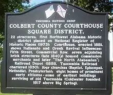
- Colbert County Courthouse Square Historic District, Tuscumbia
- Coon Dog Memorial Graveyard of Key-Underwood, Cherokee
- F.A.M.E. Recording Studios, Muscle Shoals
- Ivy Green - Birthplace of Helen Keller, Tuscumbia
- LaGrange College Site and Monument, Leighton
- Natchez Trace Parkway
- Nitrate Village Number 1 Historic District, Sheffield
- Old Railroad Bridge of 1839 on the Tennessee River
- Rosenwald School site, Cherokee
- Tennessee Valley Art Museum, Tuscumbia
- Tuscumbia Railroad Depot Museum
- TVA Walking Trails and Recreation Area
- Wilson Lock and Dam, Muscle Shoals
See also:
Annual Events
- Belle Mont Celtic Fest - May
- Muscle Shoals Area Street Rods Car Show Festival - May
- Recall LaGrange Commemorations - May
- North Alabama African Heritage Festival - June
- Leighton Juneteenth Celebration - June
- Helen Keller Festival - June
- W.C. Handy Music Festival - July
- Coon Dog Labor Day Celebration - September
- “Oka Kapassa” – Return to Cold Water American Indian Festival - September
- Annual Christmas Parades of Muscle Shoals, Tuscumbia, Sheffield - December
In popular culture
- Colbert County was featured in a three-part comedy feature on Comedy Central's The Colbert Report from November 28–30, 2006.
- Colbert County is the setting for the Drive-by Truckers song, "Putting People on the Moon"
Notable People
- Arthur Alexander
- Jason Allen - American football
- Beverly Barton
- Lefty Bates
- Deion Belue
- Boyd Bennett
- Robert Byrne - songwriter
- Marcel Black
- John A. Caddell
- Archibald Hill Carmichael
- Pete Carr
- Amanda Chase
- George Colbert
- Levi Colbert
- Mike Cooley (musician)
- Dominique Croom
- Ben Cunningham (activist)
- Rece Davis
- Bobby E. Denton
- James Deshler
- Leon Douglas
- Cecil Dowdy
- Alecia Elliott
- Henry S. Foote
- Douglas A. Foster
- Al Gamble
- Wayne Greenhaw
- Wendell Wilkie Gunn
- Rick Hall
- Howell Heflin
- Kelvin Holly
- Dennis Homan
- David Hood
- Patterson Hood
- Jimmy Hughes
- Richard H. Jackson
- Rick James (baseball)
- Jimmy Johnson (session guitarist)
- Helen Keller
- John W. Keys
- Adam Lazzara
- Maud McKnight Lindsay
- Robert B. Lindsay
- Frank Manush
- Heinie Manush
- Kenny Mims
- Guy Morton
- Alfred Huger Moses
- Stan Munsey
- Ozzie Newsome
- Gary Nichols
- Jimmie Orr
- Margaret Pellegrini
- Anthony Piccione
- Will Reynolds
- Willie Ruff
- Wimp Sanderson
- William Henry Sawtelle
- Mark Sears
- Herschel Sizemore
- Joseph Humphrey Sloss
- William H. Steele (judge)
- Phillip Swann
- Percy Sledge
- Leigh Tiffin
- Chris Tompkins
- Fred Thompson
- Ken Tribble
- Wilson D. Watson
- Ed West
- John Paul White
- William Willis (artiest)
References
- Foscue, Virginia O. (1989). Place Names in Alabama - Virginia O. Foscue - Google Books. ISBN 9780817304102. Retrieved August 4, 2014.
- "State & County QuickFacts". United States Census Bureau. Retrieved April 7, 2022.
- "Find a County". National Association of Counties. Archived from the original on May 31, 2011. Retrieved June 7, 2011.
- "Colbert County Website". Retrieved May 16, 2007.
- "Alabama Counties: Colbert County". Alabama Department of Archives and History. Montgomery, AL: Alabama Department of Archives and History. November 20, 2009. Retrieved April 30, 2012.
- Kazek, Kelly (August 19, 2014). "Legendary Coon Dog Cemetery to once again host Labor Day celebration with live music, crafts, barbecue". The Huntsville Times. Huntsville, AL. Retrieved August 20, 2014.
- "US Gazetteer files: 2010, 2000, and 1990". United States Census Bureau. February 12, 2011. Retrieved April 23, 2011.
- Alabama Railway Map Archived March 12, 2012, at the Wayback Machine. 2008. Alabama Department of Transportation. Accessed March 15, 2012.
- "Annual Estimates of the Resident Population for Counties: April 1, 2020 to July 1, 2021". Retrieved April 7, 2022.
- "U.S. Decennial Census". United States Census Bureau. Retrieved May 16, 2014.
- "Historical Census Browser". University of Virginia Library. Retrieved May 16, 2014.
- "Population of Counties by Decennial Census: 1900 to 1990". United States Census Bureau. Retrieved May 16, 2014.
- "Census 2000 PHC-T-4. Ranking Tables for Counties: 1990 and 2000" (PDF). United States Census Bureau. Retrieved May 16, 2014.
- "U.S. Census website". United States Census Bureau. Retrieved January 31, 2008.
- "Explore Census Data". data.census.gov. Retrieved December 13, 2021.
- "Dave Leip's Atlas of U.S. Presidential Elections". Retrieved November 16, 2016.
External links
Places adjacent to Colbert County, Alabama | ||||||||||||||||
|---|---|---|---|---|---|---|---|---|---|---|---|---|---|---|---|---|
| ||||||||||||||||
Municipalities and communities of Colbert County, Alabama, United States | ||
|---|---|---|
| Cities | Map of Alabama highlighting Colbert County | |
| Towns | ||
| Unincorporated communities | ||
| ||