Heaphy Track
The Heaphy Track is a popular tramping track in the north west of the South Island of New Zealand. It is located within the Kahurangi National Park and classified as one of New Zealand's ten Great Walks by the Department of Conservation. Named after Charles Heaphy, the track is 78.4 kilometres (48.7 mi) long and is usually walked in four or five days. The track runs from Kohaihai, north of Karamea on the northern west coast of the South Island to the upper valley of the Aorere River, inland from Golden Bay. After flood damage, the West Coast end of the track is currently closed.
| Heaphy Track | |
|---|---|
 Along the Heaphy River | |
| Length | 78.4 km (48.7 mi) |
| Location | Kahurangi National Park |
| Designation | New Zealand Great Walks |
| Trailheads |
|
| Use |
|
| Elevation | |
| Highest point | 915 m (3,002 ft) |
| Lowest point | 0 m (0 ft) |
| Hiking details | |
| Season |
|
| Maintained by | Department of Conservation |
History
Māori tribes are known to have settled along the lower course of the Heaphy River as early as the 16th century. Evidence has been found that the area crossed by today's Heaphy Track had been explored in pre-European times by Māori seeking greenstone (pounamu) in the Gouland Downs sector.
The first visit to the area by persons whose names were recorded took place in 1846, when Charles Heaphy, Thomas Brunner and their Māori guide Kehu (Ngāti Apa, Ngāti Tūmatakōkiri), supported by another guide Etau,[1] explored the coastal sector of the track.
The first recorded crossing of the whole range approximately along today's route was by a European gold miner named Aldrige in 1859. Another visit by James MacKay and John Clark took place the following year.[2]
During and after the West Coast Gold Rush of the 1860s the area was extensively visited for gold and the track was definitely laid out by various prospectors and surveyors, among them John Saxon in 1888.[3] No gold was found in the area and, after thirty years, prospecting came to an end. By 1900, the track was virtually forgotten and had become overgrown and seldom used except by an occasional hunter.[2]
The creation of the North-west Nelson Forest Park in 1965, which became Kahurangi National Park in 1996, led to the rediscovery and improvement of the track.[2]
The track is now tramped by thousands of people every year.[4]
Heavy rain in the Buller District in February 2022 caused significant damage. The suspension bridge over the Gunner River was damaged, the Pitt Creek bridge was swept away, and the suspension bridge over the Heaphy River was destroyed. The Heaphy River Bridge with 147.3 metres (483 ft) in length was the longest suspension bridge in the country when it was built in 2012; its deck was 6.5 metres (21 ft) above normal river level. The West Coast end of the Heaphy Track is predicted to be closed for several months.[5]
Landscape along the track
The Heaphy track is renowned for the variety of landscapes crossed; each 20 km (12 mi) section is significantly different from the previous one.
Walking the path east to west, the journey begins through a forest where beeches (Nothofagus) are dominant. Some zigzags lead to the highest point of the track at 915 m (3,002 ft), with good views to the surrounding mountains.
From there on, tussocks replace forests and the Gouland Downs are entered soon: a large featureless area drained by many rivers, with swingbridges helping to cross them when they are in flood.
Now woody patches regain over tussock moors; near Gouland Downs Hut, beeches covered by thick moss are reminiscent of the wettest forests of southern New Zealand.
After several kilometers of alternating tussock downs and bush, MacKay Hut is reached, with broad views reaching to the Tasman Sea. There begins a long descent through the bush. This time podocarps are dominant, including large rimu trees.
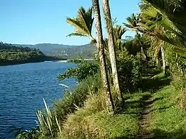
At the end of this descent, the Heaphy River valley is reached at Lewis Hut. The river course is followed for 8 km (5.0 mi) of peaceful flat walk, crossing the Heaphy River and several affluents on long swingbridges. This leads to the nikau palm forest, which is perhaps the most striking feature of the Heaphy Track.
The seashore is reached at Heaphy Hut, at the mouth of the Heaphy River. The last section is a coastal walk, alternating sandy beaches beaten by the waves and forest sections, where nikau palms dominate.
Roading debate
Repeated attempts, from the 1950s to the 1980s, by the South Island Local Bodies Association to have the Ministry of Works build an access road were made. The Ministry considered the road proposal to be too expensive and did not view it as a priority.[6]
The famed coastal strip with its iconic nikau palm groves was particularly at risk with any road construction. Even with simple track construction at Crayfish Point many years ago, the overall effect was to see major slips carry the groves into the sea. Those fighting roading proposals felt this could be the result along the very narrow, palm-covered coastal strip if road construction were to take place.
Up until the 1980s the threats to the track were real, as the local population and councils largely supported roading in the belief that a "tourist circuit" of the South Island would increase the access and popularity of the area. The track proponents argued the damage could never be justified and that the popularity would come more in the form of people being drawn to the area for days rather than those who would drive through and use "comfort stops".
The campaign to "save" the Track and the popular support the conservation effort gathered over many years became pivotal in changing the attitude of the authorities to environmental matters. The New Zealand Government instigated many changes to curb unnecessary environmental destruction.
Following the major campaigns, track use grew substantially. In 1970, a road alignment was surveyed by the Ministry of Works and this caused a period of intense debate. Track use became intense in the 1973–1974 summer season and when a three-day rainstorm hit over the New Year break, it resulted in a massive rescue mission. In the larger huts, hundreds of people were sheltering and the six-bunk Gounland Downs Hut held 82 people. The incident resulted in shelters being built in between the huts.[7]
Recently, track use has moderated to a point where it now forms an integral part of the great New Zealand walking experience. As the popularity increased, more resources were put into track maintenance and facilities. Today, the track is well defined and serviced and capable of being walked by a wide age group. A number of commercial operators now provide guiding facilities and packing ability, thus allowing a wider age group to enjoy this extended walk.
Road access
From the south, the Karamea-Kohaihai road is unsealed for the last 4 kilometres (2.5 mi), as of January 2018.
From the north, the Collingwood-Browns Hut road is sealed as far as Bainham, then unsealed for the final 15 kilometres (9.3 mi).[8] This access road became an all-weather road in 2014, when the last of three major fords near Browns Hut were bridged.
Mountain biking
Before the area became a national park, mountain biking was permitted on the track. As a national park, use of the area comes under the National Parks Act 1980 that stipulates that vehicles are not allowed to be taken off formed roads. This prevented mountain bikers from using the track and debate has been on-going to allow at least some access. The New Zealand Conservation Authority decided to permit mountain bike access again from May 2011 for the winter months when tramping numbers are low.[9] At the Golden Bay end, road access was via three fords and after ongoing concern about drivers taking risks of getting to the track, and some becoming stranded in swollen streams, DOC took the unusual step of providing funding to Tasman District Council for three bridges to be built; these were finished in 2014.[10] The mountain bike trial period ended in 2016 and mountain biking became a permanent option over the colder part of the year.[9] Mountain biking is now allowed each year from 1 May to 30 November for groups not exceeding six riders.[11]
 Brown Hut marks the Golden Bay end of the track
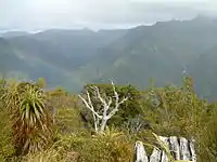 The view from the highest point of the track
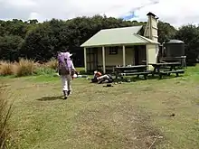
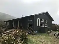 Perry Saddle Hut is near the highest point of the track
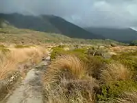 The Gouland Downs
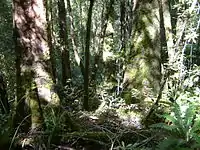 The forest west of Mackay hut
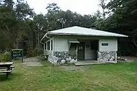
 Interior of the Lewis Hut, which was removed some time after 2018
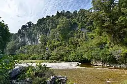 Swingbridge over the Gunner River, damaged in 2022 but repairable
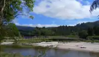 Heaphy River Bridge, destroyed in 2022
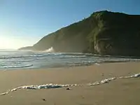 The Tasman Sea at the Heaphy River mouth
References
- Phillips, Jock, ed. (2007-09-24). "European exploration: Thomas Brunner, Nelson and the West Coast". Te Ara: the Encyclopedia of New Zealand (in English and Maori). Archived from the original on 2022-04-09. Retrieved 2022-05-01.
- Barnett, Shaun (2017-05-30). "The Heaphy Track". Wilderlife. Archived from the original on 2022-02-04.
- Murray, Paul. "Saxon Hut & Campsite". Heaphy Track. Archived from the original on 2021-04-22. Retrieved 2022-05-01.
- Roberts, Jane; Boer, Eric de; Wightwick, Ian (September 2013). "Heaphy Track Mountain Bike Trial 2011–2013" (PDF). Department of Conservation. Archived (PDF) from the original on 2019-01-31. Retrieved 2022-05-01.
- Bohny, Skara (2022-02-10). "Heaphy Track closure to last 'several months'". Stuff. Archived from the original on 2022-03-16. Retrieved 2022-02-11.
- Sage, Eugenie (2001-04-11). "Road Proposals Similar to Smashin Mona Lisa". Forest & Bird.
- Hindmarsh, Gerard (2016-08-12). "Karamea-Collingwood road an idea whose time has gone". Stuff. Archived from the original on 2022-02-14. Retrieved 2022-02-14.
- "Collingwood to Brown River Hut". Heaphy Track. Archived from the original on 2019-03-21. Retrieved 2022-05-01.
- "Greens: Heaphy Gem Opens For Mountain Bikers". Voxy (Press release). Fuseworks Media. 2010-12-08. Archived from the original on 2020-11-30. Retrieved 2010-12-08.
- Smith, Nick (2014-05-01). "New bridges opened to improve access to Heaphy Track". Beehive (Press release). Wellington, New Zealand. Archived from the original on 2022-02-14. Retrieved 2022-02-14.
- Nelson, Helen Murdoch (2010-12-10). "Happy return to Heaphy Track". The Press. Christchurch. p. A17. Archived from the original on 2022-05-01. Retrieved 2022-05-01.
Further reading
- "Heaphy Track: Golden bay area Great Walk". Department of Conservation. Archived from the original on 2022-02-23. Retrieved 2022-05-01.
- Petyt, Chris (2012-04-12). The Heaphy Track. Nelson, New Zealand: Nikau Press. ISBN 978-0-9582-8984-9. OCLC 823863745. Retrieved 2022-05-01.