Hawaii Route 93
Route 93 is a major east–west highway on the island of Oahu which begins as Interstate H-1 terminates in Kapolei and ends at Kaena Point on the extreme northwest end of Oahu, just past Makaha. It is part of the Farrington Highway.
 | ||||
|---|---|---|---|---|
| Farrington Highway | ||||
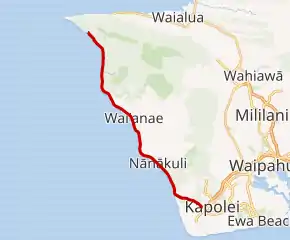 Route 93 highlighted in red | ||||
| Route information | ||||
| Maintained by HDOT | ||||
| Length | 19.524 mi[1] (31.421 km) | |||
| Major junctions | ||||
| West end | End of road in Kaʻena Point State Park | |||
| East end | ||||
| Location | ||||
| Country | United States | |||
| State | Hawaii | |||
| Highway system | ||||
| ||||
Route description
As H1 ends near Kapolei and Ko Olina, it continues as a four lane, and then two lane highway up into the Waianae and Makaha area, the "Leeward Coast", of west Oahu.
History
In the 1960s, the state government studied the feasibility of a highway around Kaena Point, which would be 6.7 miles (10.8 km) long. A rough road around the point, following a disused railroad, had already existed but was not suitable for most vehicle traffic.[2]
References
- Hawaii Department of Transportation (October 2016). "State DOT Road Inventory" (ESRI Shapefile). Retrieved July 31, 2019.
- Lund, Kay (May 9, 1968). "The rocky road to Kaena Point..." Honolulu Star-Bulletin. p. A4. Retrieved November 20, 2021 – via Newspapers.com.
This article is issued from Wikipedia. The text is licensed under Creative Commons - Attribution - Sharealike. Additional terms may apply for the media files.