Hanggin Rear Banner
Hanggin Rear Banner (Mongolian script: ᠬᠠᠩᠭᠢᠨ ᠬᠣᠶᠢᠲᠤ ᠬᠣᠰᠢᠭᠤ; Chinese: 杭锦后旗) is a banner in the west of the Inner Mongolia Autonomous Region, China. It has an area of 1,767 km2 (682 sq mi) and 217,573 inhabitants (2020). Its administrative center is the town of Shanba (Shenpa) (陕坝镇).
Hanggin Rear Banner
杭锦后旗 • ᠬᠠᠩᠭᠢᠨ ᠬᠣᠶᠢᠲᠤ ᠬᠣᠰᠢᠭᠤ | |
|---|---|
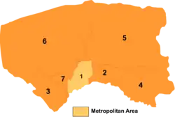 Bayannur divisions: Hanggin Rear Banner is 7 on this map | |
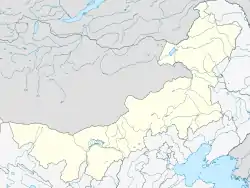 Hanggin HQ Location of the seat in Inner Mongolia | |
| Coordinates: 40°49′45″N 107°00′47″E | |
| Country | People's Republic of China |
| Autonomous region | Inner Mongolia |
| Prefecture-level city | Bayannur |
| Area | |
| • Total | 1,791 km2 (692 sq mi) |
| Population (2020)[1] | |
| • Total | 217,573 |
| • Density | 120/km2 (310/sq mi) |
| Time zone | UTC+8 (China Standard) |
| Hanggin Rear Banner | |||||||||||
|---|---|---|---|---|---|---|---|---|---|---|---|
| Chinese name | |||||||||||
| Simplified Chinese | 杭锦后旗 | ||||||||||
| Traditional Chinese | 杭錦後旗 | ||||||||||
| |||||||||||
| Mongolian name | |||||||||||
| Mongolian Cyrillic | Қанин Қоыиту қосиу | ||||||||||
| Mongolian script | ᠬᠠᠩᠭᠢᠨ ᠬᠣᠶᠢᠲᠤ ᠬᠣᠰᠢᠭᠤ | ||||||||||
| |||||||||||
Transportation
Hanggin Rear Banner is served by the Linhe-Ceke Railway.
External links
This article is issued from Wikipedia. The text is licensed under Creative Commons - Attribution - Sharealike. Additional terms may apply for the media files.