Guhrow
Guhrow (Lower Sorbian: Góry) is a municipality in the district of Spree-Neiße, in Brandenburg, Germany.
Guhrow
Góry | |
|---|---|
Location of Guhrow within Spree-Neiße district 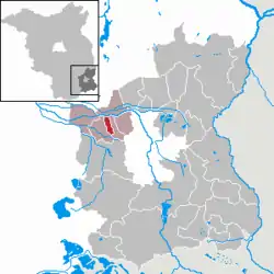 | |
 Guhrow  Guhrow | |
| Coordinates: 51°49′N 14°14′E | |
| Country | Germany |
| State | Brandenburg |
| District | Spree-Neiße |
| Municipal assoc. | Burg (Spreewald) |
| Government | |
| • Mayor (2019–24) | Kerstin Jaser[1] |
| Area | |
| • Total | 6.62 km2 (2.56 sq mi) |
| Elevation | 58 m (190 ft) |
| Population (2020-12-31)[2] | |
| • Total | 534 |
| • Density | 81/km2 (210/sq mi) |
| Time zone | UTC+01:00 (CET) |
| • Summer (DST) | UTC+02:00 (CEST) |
| Postal codes | 03096 |
| Dialling codes | 035606 |
| Vehicle registration | SPN |
| Website | www.amt-burg-spreewald.de |
Demography
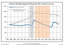
Development of population since 1875 within the current Boundaries (Blue Line: Population; Dotted Line: Comparison to Population development in Brandenburg state; Grey Background: Time of Nazi Germany; Red Background: Time of communist East Germany)
|
|
References
- Landkreis Spree-Neiße Wahl der Bürgermeisterin / des Bürgermeisters, accessed 2 July 2021.
- "Bevölkerung im Land Brandenburg nach amtsfreien Gemeinden, Ämtern und Gemeinden 31. Dezember 2020". Amt für Statistik Berlin-Brandenburg (in German). June 2021.
- Detailed data sources are to be found in the Wikimedia Commons.Population Projection Brandenburg at Wikimedia Commons
This article is issued from Wikipedia. The text is licensed under Creative Commons - Attribution - Sharealike. Additional terms may apply for the media files.