Ash Township, Michigan
Ash Township is a civil township of Monroe County in the U.S. state of Michigan. As of the 2010 census, the township population was 7,610.[3]
Ash Township, Michigan | |
|---|---|
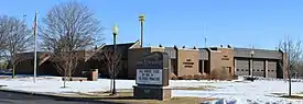 Ash Township Hall and Fire Department | |
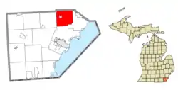 Location within Monroe County (red) and the administered village of Carleton (pink) | |
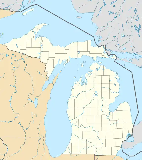 Ash Township Location within the state of Michigan  Ash Township Location within the United States | |
| Coordinates: 42°03′23″N 83°22′31″W | |
| Country | United States |
| State | Michigan |
| County | Monroe |
| Organized | 1837 |
| Government | |
| • Supervisor | Robin Carmack |
| • Clerk | Michele Geiermann |
| Area | |
| • Total | 34.84 sq mi (90.24 km2) |
| • Land | 34.60 sq mi (89.61 km2) |
| • Water | 0.24 sq mi (0.62 km2) |
| Elevation | 604 ft (184 m) |
| Population (2010) | |
| • Total | 7,783 |
| • Density | 224.9/sq mi (86.8/km2) |
| Time zone | UTC-5 (Eastern (EST)) |
| • Summer (DST) | UTC-4 (EDT) |
| ZIP code(s) | |
| Area code(s) | 734 |
| FIPS code | 26-03680[1] |
| GNIS feature ID | 1625853[2] |
| Website | Official website |
Communities
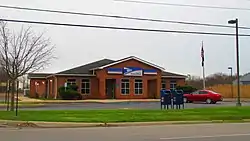
- Carleton is a village in the west-central portion of the township.
- Clark City was built around a stave mill along Swan Creek. It had a post office from 1855 until 1866.[4]
- Grafton is an unincorporated community located within the township at 42°02′12″N 83°23′23″W.[5] It is located along the railway line and contained its own post office from March 14, 1850 to April 30, 1903.[6]
History
Ash Township was organized in 1837 from a northern portion of Frenchtown Township. The township was named after local resident Arba Ash, who proposed the name during an early township meeting.[7]
Geography
According to the U.S. Census Bureau, the township has a total area of 34.84 square miles (90.24 km2), of which 34.60 square miles (89.61 km2) is land and 0.24 square miles (0.62 km2) (0.70%) is water.[3]
Transportation
Airport
 Buzzwick Airport is a public-use airport located within the township.
Major highways
Education
Ash Township is served by three separate school districts. The vast majority of the township is served by Airport Community Schools. A few very small northern portions of the township along Will Carleton Road are served by Huron School District in Huron Township in Wayne County. Another very small northeastern portion of the township along Telegraph Road is served by Flat Rock Community Schools in Flat Rock in Wayne County.[8]
Demographics
As of the census[1] of 2000, there were 7,610 people, 2,801 households, and 2,125 families residing in the township. The population density was 220.0 per square mile (84.9/km2). There were 2,942 housing units at an average density of 85.0 per square mile (32.8/km2). The racial makeup of the township was 97.08% White, 0.32% African American, 0.32% Native American, 0.22% Asian, 0.01% Pacific Islander, 0.33% from other races, and 1.72% from two or more races. Hispanic or Latino of any race were 1.75% of the population.
There were 2,801 households, out of which 35.6% had children under the age of 18 living with them, 61.4% were married couples living together, 9.7% had a female householder with no husband present, and 24.1% were non-families. 20.3% of all households were made up of individuals, and 7.1% had someone living alone who was 65 years of age or older. The average household size was 2.72 and the average family size was 3.13. In the township the population was spread out, with 27.5% under the age of 18, 8.3% from 18 to 24, 29.4% from 25 to 44, 24.5% from 45 to 64, and 10.1% who were 65 years of age or older. The median age was 36 years. For every 100 females, there were 100.8 males. For every 100 females age 18 and over, there were 97.8 males.
The median income for a household in the township was $54,439, and the median income for a family was $61,020. Males had a median income of $47,892 versus $25,699 for females. The per capita income for the township was $24,271. About 4.6% of families and 6.3% of the population were below the poverty line, including 9.0% of those under age 18 and 4.7% of those age 65 or over.
References
- "U.S. Census website". United States Census Bureau. Retrieved 2008-01-31.
- U.S. Geological Survey Geographic Names Information System: Ash Township, Michigan
- "Michigan: 2010 Population and Housing Unit Counts 2010 Census of Population and Housing" (PDF). 2010 United States census. United States Census Bureau. September 2012. p. 34 Michigan. Retrieved January 20, 2022.
- Romig 1986, p. 118.
- U.S. Geological Survey Geographic Names Information System: Grafton, Michigan
- Romig 1986, p. 231.
- Ash Township (2022). "About Ash Township: Ash Township History". Retrieved January 20, 2022.
- Michigan Geographic Framework (15 November 2013). "Monroe County School Districts" (PDF). Retrieved December 28, 2021.
Sources
- Romig, Walter (October 1, 1986) [1973]. Michigan Place Names: The History of the Founding and the Naming of More Than Five Thousand Past and Present Michigan Communities. Great Lakes Books Series (Paperback). Detroit, Michigan: Wayne State University Press. pp. 118, 231. ISBN 978-0-8143-1838-6.
Municipalities and communities of Monroe County, Michigan, United States | ||
|---|---|---|
| Cities | 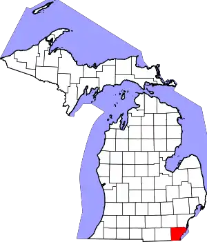 Map of Michigan highlighting Monroe County | |
| Villages | ||
| Charter townships | ||
| Civil townships | ||
| CDPs | ||
| Other unincorporated communities |
| |
| Ghost towns | ||
| Footnotes | ‡This populated place also has portions in an adjacent county or counties | |
| ||