Geography of the Czech Republic
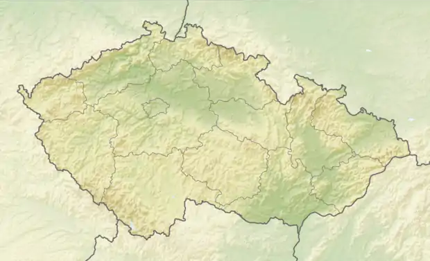
The Czech Republic is a land-locked country in Central Europe. It is bordered by Germany to the west, Austria to the south, Slovakia to the east and Poland to the north. It consists mostly of low hills and plateaus surrounded along the borders by low mountains. Two areas of lowlands follow the Elbe river and the Morava river. About a third of the area of the Czech Republic is covered by forests.
 | |
| Continent | Europe |
|---|---|
| Region | Central Europe |
| Area | Ranked 115th |
| • Total | 78,871 km2 (30,452 sq mi) |
| • Land | 97.88% |
| • Water | 2.12% |
| Coastline | 0 km (0 mi) |
| Borders | 2,143 km [1] |
| Highest point | Sněžka, 1603.3 m |
| Lowest point | Hřensko, 115 m |
| Longest river | Vltava, 433 km |
| Largest lake | Černé, 18.4 ha |
| Climate | temperate |
| Terrain | hills and lowlands surrounded by low mountains |
| Natural resources | kaolin, lithium, graphite, black coal, brown coal, uranium, timber |
The Czech Republic also possesses Moldauhafen, a 30,000 m2 enclave in the middle of Hamburg docks in Germany, which was awarded to Czechoslovakia by Article 363 of the Treaty of Versailles to allow the landlocked country a place where goods transported down river could be transferred to seagoing ships. This territory reverts to Germany in 2028.
Physical geography
Climate
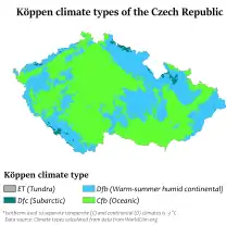
The Czech Republic's climate is temperate, transitional between an oceanic climate and a continental climate. The summers are rather cool and dry, with average temperatures in most areas around 20 °C, the winters are fairly mild and wet with temperatures averaging around 0 °C in most areas. The relative humidity moves between 60 and 80 %.
Geology
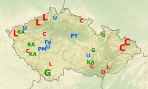
Most of the area of the Czech Republic belongs to the geographically stable Bohemian Massif. Only an area of the Western Carpathians in the east of the country is younger, lifted during the Tertiary. Igneous rocks make up the base of the Bohemian Massif. Sedimentary rocks are mostly found in the north-eastern part of Bohemia with significant areas of sandstone. Among the metamorphic rocks, the most commonly found is Gneiss.
Mountains
The most notable mountain ranges in the Czech Republic are all found along the borders of the country. In Bohemia it is the Bohemian Forest and Ore Mountains, both bordering Germany. Then the long region of Sudetes with several mountains ranges, including Giant Mountains with Sněžka – the highest peak of the Czech Republic. The last major mountain range is the Moravian-Silesian Beskids in the east.
Rivers
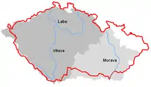
There are four major rivers in the Czech Republic. The Elbe flows from the Giant Mountains in the north east of Bohemia to the west and then flows through northern Germany all the way to the North Sea. The Morava River drains most of Moravia and flows to the south into Danube and ultimately to the Black Sea. The Oder starts in the Moravian Silesia and flows north through Poland into the Baltic Sea. The fourth major river is the Vltava, which is the longest river of the Czech Republic and drains the southern part of Bohemia before flowing into the Elbe in Mělník.
Bodies of water
Natural occurring bodies of water are rather scarce, most of the significant bodies of water are man-made ponds and reservoirs. The largest pond is the Rožmberk Pond, which is one of the ponds in the system of fish ponds built in the 16th century around Třeboň. The largest reservoir by area covered is the Lipno Reservoir (4,870 ha), built in the 1950s and the largest reservoir by cubic capacity is Orlík Reservoir (716,000,000 m3), built around the same time.
Human geography
Population geography
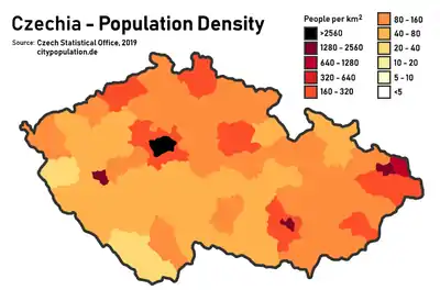
The population of the Czech Republic is estimated to be around 10.6 million. The highest population density is in the larger metropolitan area of Ostrava and of course in the area around the capital of Prague. The lowest population density is in the Czech-German and Czech-Austrian borderlands, mostly as a lasting result of the expulsion of Germans from Czechoslovakia after the World War II.
Political geography
The Czech Republic is divided into thirteen regions and one capital city with regional status. The older administrative units of seventy-six districts are still recognized and remain the seats of various branches of state administration. Historically, the Czech Republic can be split into three regions: Bohemia in the west, Moravia in the east and Czech Silesia in the north east.
Industry and agriculture
Areas affected the most by heavy industry are the Sokolov Basin and the Most Basin in the north-west of the Czech Republic. The extensive deposits of brown coal in those areas are mostly used for electricity production. It is estimated, that almost 40% of all electric power produced in the Czech Republic comes from burning brown coal mined in these areas. Plant agriculture is focused around the lowlands surrounding the Elbe and the Morava. Around 34% of the country is covered by forests and approximately 37% of land is arable. The area of irrigated land is estimated to spread across 385 km2 and freshwater withdrawal per capita is around 164 m3 every year.
Important cities
| Rank | Name | Region | Pop. | Rank | Name | Region | Pop. | ||
|---|---|---|---|---|---|---|---|---|---|
 Prague  Brno |
1 | Prague | Prague | 1,313,508 | 11 | Zlín | Zlín | 75,112 | 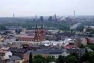 Ostrava  Plzeň |
| 2 | Brno | South Moravian | 377,440 | 12 | Havířov | Moravian-Silesian | 75,049 | ||
| 3 | Ostrava | Moravian-Silesian | 294,200 | 13 | Kladno | Central Bohemian | 68,552 | ||
| 4 | Plzeň | Plzeň | 169,033 | 14 | Most | Ústí nad Labem | 67,089 | ||
| 5 | Liberec | Liberec | 102,562 | 15 | Opava | Moravian-Silesian | 57,772 | ||
| 6 | Olomouc | Olomouc | 100,378 | 16 | Frýdek-Místek | Moravian-Silesian | 56,945 | ||
| 7 | Ústí nad Labem | Ústí nad Labem | 93,409 | 17 | Karviná | Moravian-Silesian | 55,985 | ||
| 8 | České Budějovice | South Bohemian | 93,285 | 18 | Jihlava | Vysočina | 50,521 | ||
| 9 | Hradec Králové | Hradec Králové | 92,808 | 19 | Teplice | Ústí nad Labem | 50,079 | ||
| 10 | Pardubice | Pardubice | 89,693 | 20 | Děčín | Ústí nad Labem | 49,833 | ||
See also
References
- "Czechia". CIA World Factbook. Retrieved 1 February 2021.
- "2011 census" (in Czech). Czech Statistical Office. Retrieved 1 January 2015.
![]() This article incorporates public domain material from the CIA World Factbook website https://www.cia.gov/the-world-factbook/.
This article incorporates public domain material from the CIA World Factbook website https://www.cia.gov/the-world-factbook/.