Fune
Fune is a Local Government Area in Yobe State, Nigeria. Its headquarters are in the town of Damagum in the southwest of the area on the A3 highway at11°40′39″N 11°20′04″E.
Fune | |
|---|---|
| Motto(s): Fune tafi Jam'iyya | |
 Fune Location in Nigeria | |
| Coordinates: 11°53′N 11°54′E | |
| Country | |
| State | Yobe State |
| Government | |
| • Local Government Chairman | Baba Goni Bade (APC) |
| Area | |
| • Total | 4,948 km2 (1,910 sq mi) |
| Population (2006 census) | |
| • Total | 300,760 |
| Time zone | UTC+1 (WAT) |
| 3-digit postal code prefix | 622 |
| ISO 3166 code | NG.YO.FU |
It has an area of 4,948 km2 and a population of 300,760 at the 2006 census.
The postal code of the area is 622.[1]
The main Settlement tribe of Fune Local Governments are Kare-kare, Ngizim, Kanuri and Fulani. The Current Emir of Fune is Alhaji (Dr.) Saleh Idriss Ibn Uthman with his Palace situated at Damagum the head quarter of Fune Local Government.
In 1987, the 8,000-year-old Dufuna canoe was discovered in Fune, near the village of Dufuna and the Komadugu Gana River.[2]
Geography
The northeasterly line of equal latitude and longitude passes through the area including 11°30′00″N 11°30′00″E.
References
- "Post Offices- with map of LGA". NIPOST. Archived from the original on 2009-10-07. Retrieved 2009-10-20.
- (16 September 2002). Dufuna Canoe: A Bridge Across 8,000 Years, Daily Trust (All Africa Global Media via COMTEX)
State capital: Damaturu | ||
| Local Government Areas | 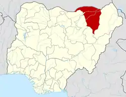 | |