Fujian Province, Republic of China
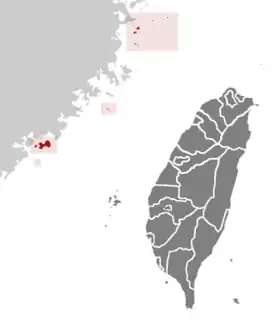
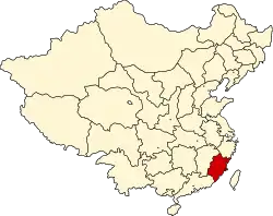
Fujian Province ([fǔ.tɕjɛ̂n] (![]() listen); Hokkien POJ: Hok-kiàn; Fuzhou BUC: Hók-gióng; Pu-Xian Min BUC: Ho̤h-ge̤̍ng); also romanized as Fuchien or Fukien is a nominal province of the Republic of China without formal administrative function. It includes three small archipelagos off the coast of the Fujian Province of the People's Republic of China, namely the Matsu Islands, which make up Lienchiang County, and the Wuqiu Islands and Kinmen Islands, which make up Kinmen County. Its claimed de jure capital is Fuzhou, while its claimed largest city by population is Quanzhou, both located near the coast of the Taiwan Strait in the east of the province. The seat of the provincial government is Jincheng Township of Kinmen County serves as its de facto capital.[note 3]
listen); Hokkien POJ: Hok-kiàn; Fuzhou BUC: Hók-gióng; Pu-Xian Min BUC: Ho̤h-ge̤̍ng); also romanized as Fuchien or Fukien is a nominal province of the Republic of China without formal administrative function. It includes three small archipelagos off the coast of the Fujian Province of the People's Republic of China, namely the Matsu Islands, which make up Lienchiang County, and the Wuqiu Islands and Kinmen Islands, which make up Kinmen County. Its claimed de jure capital is Fuzhou, while its claimed largest city by population is Quanzhou, both located near the coast of the Taiwan Strait in the east of the province. The seat of the provincial government is Jincheng Township of Kinmen County serves as its de facto capital.[note 3]
Fujian Province
福建省 | |
|---|---|
| Name transcription(s) | |
| • Chinese | 福建省 (Fújiàn Shěng) |
| • Abbreviation | FJ / 閩 (pinyin: Mǐn, POJ: Bân) |
| • Foochow | Hók-gióng |
| • Hokkien POJ | Hok-kiàn |
 Seal of Fujian Province | |
 Map showing subdivisions under de facto administration of the nominal province in 2019 | |
| Coordinates: 24°25′N 118°19′E | |
| Country | |
| Streamlined | 16 July 1956 |
| Demilitarised | 7 November 1992 |
| Dissolved | 31 December 2018 |
| Named for | |
| Provincial capital | Fuzhou (claimed, de jure)[note 1] |
| Largest city | Fuzhou (claimed, de jure) Jincheng, Kinmen (de facto) |
| Government | |
| • Body | Kinmen-Matsu Joint Services Center[note 2] |
| Area | |
| • 1948 | 121,580 km2 (46,940 sq mi) |
| • 2018 | 180.4560 km2 (69.6745 sq mi) |
| Population (2014) | |
| • Total | 133,456 |
| Demonym(s) | Fujianese, Fukienese, Kinmenese, Matsunese |
| Time zone | UTC+8 (Asia/Taipei) |
| Postal code | 209–212, 890–896 |
| Area code(s) | (0)82, (0)826, (0)836 |
| ISO 3166 code | TW |
| Counties | 2 |
| Website | www.fkpg.gov.tw |


.svg.png.webp)
Min Chinese is most commonly spoken within the province, including the Fuzhou dialect of northeastern Fujian and various dialects of Hokkien locally called Kinmenese. Following constitutional reforms launched in 1996, the ROC authorities decided to downsize the provincial structure to solve the problem of overlapping personnel and administrative resources between the provincial and central governments, and cut excessive public spending.[1] The provinces were streamlined and ceased to be self-governing bodies in December 1998, with their administrative functions transferred to the Executive Yuan's subsidiary National Development Council, as well as second-tier local governments such as counties. The Kinmen-Matsu Joint Services Center was founded in 2017 and all provincial governmental organs were de facto formally abolished by July 2018, with the remaining functions transferred to the ministries of the Executive Yuan and the NDC.[2][3][4]
History
Ancient
Back then the ancient Min people and other Austronesians resided throughout Kinmen and Wuqiu islands now under the jurisdiction of Fujian Province, Republic of China.
The Tang dynasty oversaw the next golden age for Fujian. As the Tang dynasty ended another major wave of immigration arrived in the safe haven of Fujian, King Zhongyi established the Min Kingdom. After the death of the founding king, however, the kingdom suffered from internal strife, and was soon swallowed up by other kingdoms, another southern kingdom.[5]
Quanzhou was blooming into a seaport under the reign of the Min Kingdom, and is the largest seaport in the world. Its population is also greater than Fuzhou.[6][7][8] Just
Contemporary
It came under Japanese sea blockade during WW2. After Communist victory over much of Republican China, the Nationalists relocate to Taiwan. ROC continues to control a number of offshore islands of Fujian, and has continued to maintain a separate Fujian Provincial Government to govern these islands, parallel to Fujian province of PRC.
In 1956, due to heightened potential for military conflict with the PRC, the ROC central government moved the Fujian provincial government out of Fujian to within Taiwan Province in Xindian (now part of New Taipei), and the islands were placed under an extraordinarily tight military administration due to their extreme proximity to mainland China. This was an unusual situation where the government of a province was located and operating in a different province. With the easing of cross-strait relations between the PRC and ROC and the democratization of the ROC in the 1990s, the islands were returned to civilian government in 1992. On 15 January 1996, the provincial government moved back to Kinmen, on Fujian soil.[9]
Beginning in 2010, the ROC significantly diluted the powers of the two provinces it governs, namely Taiwan and Fujian. Most of the authority at the Fujian province level has been delegated to the two county governments of Kinmen and Lienchiang.
Government
The Governor of Fujian Province was the head of the Fujian Provincial Government, the governor was also titled the "Chairperson of the Fujian Provincial Government". According to the Additional Articles of the Constitution, the governor is appointed by the central government.
The Fujian Provincial Government was located in Jincheng, Kinmen between January 1996 and 2018. In July 2018, the Executive Yuan decided to transfer the duties and functionalities of the provincial government to other branches under the Executive Yuan, including Kinmen-Matsu Joint Services Center[10] and National Development Council[11] The transformations were scheduled to be done by the end of year 2018.
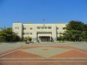 Fujian Provincial Government building between January 1996 to 2018. Currently the Kinmen-Matsu Joint Services Center, Executive Yuan building. |
Subdivisions
Fujian province nominally comprises two counties: Kinmen County and Lienchiang County. These islands have a total area of 182.66 km2 (70.53 sq mi) and a total population of 71,000 (2001).
The following are the islands of Fujian under the administration of the ROC, given by county:
| Name | Kinmen County | Lienchiang County |
|---|---|---|
| Chinese | 金門縣 | 連江縣 |
| Hokkien | Kim-mn̂g-koān | Liân-kang-koān |
| Hakka | Kîm-mùn-yen | Lièn-kông-yen |
| Matsunese | Gĭng-muòng-gâing | Lièng-gŏng-gâing |
| Wuqiunese | Ging-meóng-gā̤ⁿ | Léng-gang-gā̤ⁿ |
| Map | 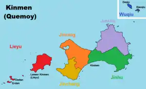 |
.svg.png.webp) |
| Islands | numerous islands & islets[12][13][14] | 36 islands |
|
| |
| Administrative divisions | 6 townships | 4 townships |
The PRC claims Kinmen as a county of Quanzhou, Fujian and the Matsu Islands as a township of Lianjiang County, Fuzhou, Fujian (with some islands claimed as parts of other areas).
See also
Notes
- Fujian Provincial Government
- Between 1956 and 1996, Xindian City in Taipei County served as the seat of government.
References
- Bi-yu Chang (24 March 2015), "The rise and fall of Sanminzhuyi Utopia", Place, Identity, and National Imagination in Post-war Taiwan, Routledge, pp. 136–138, ISBN 9781317658122.
- Sarah Shair-Rosenfield (November 2020). "Taiwan combined" (PDF). The University of North Carolina at Chapel Hill. Retrieved 29 May 2021.
- Sherry Hsiao (29 June 2018). "Provincial-level agencies to be defunded next year". Taipei Times. Retrieved 29 May 2021.
- "賴清德宣示「省級機關走入歷史」". 28 June 2018. Retrieved 17 July 2018.
- Fukien. (2008). In Encyclopedia Britannica. Retrieved 20 December 2008, from Encyclopædia Britannica Online: http://www.britannica.com/EBchecked/topic/221639/Fujian
- 伊本・白图泰(著)、马金鹏(译),《伊本・白图泰游记》,宁夏人民出版社,2005年
- "中国网事:千年古港福建"泉州港"被整合改名引网民争议". 新华网. Retrieved 17 August 2014.
- Skinner, George William; Baker, Hugh D. R. (1977). The City in late imperial China. Stanford University Press. p. 197. ISBN 978-0-8047-0892-0. Retrieved 19 January 2012.
- Fujian Provincial Government website Archived 14 April 2009 at the Wayback Machine
- "The personnel of the provincial government will be transferred to Kinmen-Matsu Joint Service Center, Executive Yuan". Retrieved 29 November 2018.
- "Taiwan Provincial Government Official Website". Archived from the original on 29 January 2019. Retrieved 17 July 2018.
- 金門縣行政區域圖 (in Chinese (Taiwan)). Retrieved 9 August 2019.
北碇島 母嶼 白巖 草嶼 東割 烽遂角 后嶼 官澳礁 西園嶼 建功嶼 黑巖 大巖嶼 烏礁 桂子礁 獅嶼 牛心礁 小擔 檳榔嶼 烈嶼 復興嶼 猛虎嶼 兔嶼 石山 大膽島 二擔島 三擔島 四擔島 五擔 大坵島 小坵島
- "金門地區限制(禁止)水域圖" (PDF) (in Chinese (Taiwan)). Mainland Affairs Council. Retrieved 9 August 2019.
二.限制水域範圍:大金門地區低潮線向外延伸東方海面四千至六千公尺,南方海面八千至一萬公尺,北碇以東海面四千公 尺,大、二膽南海面二千公尺一線以內海域 三、禁止水域範圍:大金門地區低潮線向外延伸東方海面四千公尺,南方海面八千公尺,馬山北方一千五百公尺,北碇以東 海面四千公尺,大、二膽北、西、南海面二千公尺,小金門西海面、檳榔嶼、三腳礁、牛心礁、赤角礁一線以內海域
- 辞海第六版. Cihai (Sixth Edition) (in Chinese). 上海. Shanghai: 上海辞书出版社. Shanghai Lexicographical Publishing House. September 2009. p. 1124. ISBN 9787532628599.
金门 县名。在福建省东南海上、泉州市西南部。现由台湾省管辖。由以金门岛为主的大、小59个岛屿组成。面积149平方千米,人口约6.45万(2004年)。明置金门千户所,清设金门县丞,属同安县。1913年改隶思明县,1914年析置金门县。1928年直属福建省。农产有甘薯、花生等。矿产有玻璃砂、高岭土、铝土、煤。工业有机械、食品等。特产贡糖、高粱酒、金门马等。通公路。名胜古迹有成功洞、鲁王墓、水尾塔等。{...}金门岛 亦称“大金门岛”、“吾洲屿”。在福建省东南部、厦门港口外台湾海峡中。属金门县,现由台湾省管辖。岛形如哑铃,东西宽,南北狭,中多丘陵,沿海多港湾、口岸。东西长约20千米,面积131.7平方千米。其西有小金门岛。名胜古迹有牧马侯(陈渊)祠、鲁王墓、海印寺、古岗湖、中山纪念林等。
External links
| Wikimedia Commons has media related to Fujian Province, Republic of China. |
- ROC Fujian Provincial Government (in Chinese)
 Geographic data related to Fujian Province, Republic of China at OpenStreetMap
Fujian topics | |
|---|---|
| General | |
| Geography | |
| Education | |
| Culture |
|
| Cuisine | |
| Visitor attractions | |
| |
- Sarah Shair-Rosenfield (November 2020). "Taiwan combined" (PDF). The University of North Carolina at Chapel Hill. Retrieved 29 May 2021.