Fruitville, Florida
Fruitville is a census-designated place (CDP) in Sarasota County, Florida, United States. The population was 15,484 at the 2020 census.[4] It is part of the North Port–Sarasota–Bradenton Metropolitan Statistical Area.
Fruitville, Florida | |
|---|---|
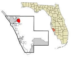 Location in Sarasota County and the state of Florida | |
| Coordinates: 27°19′50″N 82°27′42″W[1] | |
| Country | |
| State | |
| County | Sarasota |
| Area | |
| • Total | 7.13 sq mi (18.46 km2) |
| • Land | 6.82 sq mi (17.68 km2) |
| • Water | 0.30 sq mi (0.78 km2) 4.21% |
| Elevation | 30 ft (9 m) |
| Population (2020) | |
| • Total | 15,484 |
| • Density | 2,269.05/sq mi (876.04/km2) |
| Time zone | UTC−05:00 (Eastern Time Zone) |
| • Summer (DST) | UTC−04:00 (EDT) |
| ZIP code | 34232 |
| Area code(s) | 941 |
| FIPS code | 12-25000 |
| GNIS feature ID | 0282846[3] |
History
| Historical population | |||
|---|---|---|---|
| Census | Pop. | %± | |
| 1960 | 2,131 | — | |
| 1970 | 1,531 | −28.2% | |
| 1980 | 3,070 | 100.5% | |
| 1990 | 9,808 | 219.5% | |
| 2000 | 12,741 | 29.9% | |
| 2010 | 13,224 | 3.8% | |
| 2020 | 15,484 | 17.1% | |
| source:[5] | |||
In the late 1870s, a new wave of pioneers began to settle in Florida thanks to a growing orange industry.[6] In 1876, a man by the name of Charles Reaves settled in what is now considered Fruitville. According to some sources, he was the one who named the area Fruitville after the abundance of fruit in the area.[7] Reaves would go on to become the postmaster for the area's 115 residents. The first church in Sarasota County was the Friendship Baptist Church. The church was chartered in 1875 and a small pine log structure was used for the congregation until a new church was erected in 1876, using some of the original lumber from the first church.[8] In 1887, the Florida Mortgage and Investment Company of Scotland donated land to the church for the establishment of the community's first cemetery.[9]
Also in 1887, Charles and his wife Martha Tatum Reaves converted their corncrib into Fruitville's first school for their three children and seven neighbors. They went on to hire Miss Josie Clower as the first teacher in the area.[10][11] After citizens petitioned for a modern school building, funding was granted from the Works Progress Administration to build Fruitville Elementary in 1941. Rural schools in the nearby villages of Tatum Ridge and Old Myakka were closed, with their students bussed to the new school in Fruitville.[12]
A map from 1902 shows Fruitville on the map as a community.[13]
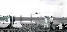
In May 1918, Franklin Field (named after then-mayor George Franklin) began operating as a military airfield during World War I. The Franklin airfield was located north of Fruitville Road and east of what is now Tuttle road. The airfield was an auxiliary landing station for the U.S. Army Air Service and housed, at the least, several Curtiss JN "Jenny" planes.[14] With the war over, the airfield saw less and less traffic and was likely unused by 1920. In 1924 the land was developed for a new subdivision.[15]
In November 1990, Litchfield's Cinema 10 opened in the Sarasota Commons, the community's first modern movie theater. As a promotion, the theater offered tickets for only 50 cents during its opening. Some of the films shown for its pre-opening weekend were Pretty Woman and Back to the Future III.[16]
On December 8, 2001, the Fruitville Public Library was opened to serve the Fruitville community as a part of the Sarasota County Library System. The library was initially called East County Library throughout its land-use planning process before the Sarasota County Commission renamed the library a month prior to its opening.[17][18]
Geography
According to the United States Census Bureau, the CDP has a total area of 7.13 square miles (18.46 km2), of which 6.83 square miles (17.68 km2) is land and 0.30 square miles (0.78 km2), or 4.21%, is water.[19]
Demographics
As of the 2020 United States Census, there was a population of 15,484 people and 6,043 households. In terms of age, 4% were under 5 years old, 15% were 18 years or younger, 45% were between 18 and 64, and %26 were 65 years or older. 91% of the population was white, 2.1% was black or African American, 2.4% was Asian, and 12.5% was Hispanic or Latino. Median household income was $72,512. There was a population of 1,945.6 per square mile.[20]
References
- "US Gazetteer files: 2010, 2000, and 1990". United States Census Bureau. February 12, 2011. Retrieved April 23, 2011.
- "2020 U.S. Gazetteer Files". United States Census Bureau. Retrieved October 31, 2021.
- "US Board on Geographic Names". United States Geological Survey. October 25, 2007. Retrieved January 31, 2008.
- U.S. Census Bureau (2020). Total Population in Fruitville CDP, Florida. Retrieved from https://data.census.gov/cedsci/all?q=Fruitville%20Florida
- "Census of Population and Housing". U.S. Census Bureau. Retrieved January 15, 2019.
- History & Preservation Coalition, http://historicpreservationsarasota.org/sarasotahistory/
- "Land of Sarasota: A Settlement in the Wilderness - This pamphlet sets forth the story of Sarasota, Florida in a simple, yet interesting fashion. It was written for the school children of Sarasota County.The history of the immediate area of Sarasota begins with the land itself, for that is about the only trace we have of any former residents. Often evidence of man's earliest activities is submerged beneath the waters of the Gulf or in a deep spring. The native people were believed to be hunters and fishersBy the beginning of the 18th century, Florida had almost no native Indians. The Seminole Indians, originally from Georgia moved south into Florida and claimed the area as theirs.In 1842 the Armed Occupation Act opened up many new land areas for pioneer development. This act provided 160 acres of land to any settler who, 1. Was the head of a family or 18 years old, 2. Could bear arms, 3. Would build a home, 4. Would live on the land for at least five years. William Whitaker became Sarasota's first permanent settler. He staked a claim under the Armed Occupation Act. He chose an elevated parcel of land overlooking the bay and called it "Yellow Bluffs."South of Sarasota a Georgia cattleman, Jesse Knight, established a homestead in what is now Nokomis, in 1868.John Webb moved down in 1867 and claimed a homestead at "Spanish Point," in what is now Osprey.Isaac Redd chose an area farther east in 1867. The abundance of bees furnished honey for all who came here. By 1877 the Bee Ridge Post Office was established.Charles Reeves settled in 1876 and used his own money to build a school and a road. Because of the abundance of fruit in this area, he called it Fruitville.History is further traced from Sarasota becoming incorporated in 1902, to the Ringlings choosing Sarasota for their circus winter quarters, the Great Depression of 1929, and of course, the outbreak of World War II. There is also a section on Sarasota today. | Venice Museum & Archives".
- State Archives of Florida/Works Progress Administration. Retrieved from https://www.floridamemory.com/items/show/251255
- The Genealogical Society of Sarasota (2007). Cemeteries of Sarasota County Florida A Record of Births, Deaths, and Burials. Retrieved from http://sites.rootsweb.com/~flgss/CemeteryFiles/FriendshipBaptistCemetery.pdf 12/17/2021
- "Overview / About Fruitville".
- "Fruitville Elementary School - Florida Historical Markers on Waymarking.com". Waymarking.
- "Sarasota's Journey from Depression to War | Sarasota History Alive!".
- "Cram's Florida, 1902" (Map). State Archives of Florida, Florida Memory. George F. Cram. 1902. Retrieved November 30, 2021.
- "Army "Jenny" planes and observers at Franklin Field in Sarasota". State Archives of Florida, Florida Memory. 1918. Retrieved November 30, 2021.
- Sunday Favorites: The Intrigue of Aviation, The Bradenton Times. Retrieved from https://thebradentontimes.com/sunday-favorites-the-intrigue-of-aviation-p21183-133.htm
- "Sarasota Crossings 10 in Sarasota, FL". Cinema Treasures. Retrieved November 30, 2021.
- "About Us". Friends of the Fruitville Public Library. Retrieved November 30, 2021.
- "Commission votes to rename library". Sarasota Herald-Tribune. November 8, 2001. Retrieved November 30, 2021 – via NewsBank.
- "Geographic Identifiers: 2010 Demographic Profile Data (G001): Fruitville CDP, Florida". U.S. Census Bureau, American Factfinder. Archived from the original on February 12, 2020. Retrieved April 11, 2013.
- United States Census Bureau. "Quick Facts: Fruitville CDP, Florida; United States". Retrieved April 15, 2022.
Municipalities and communities of Sarasota County, Florida, United States | ||
|---|---|---|
| Cities | 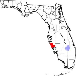 | |
| Town | ||
| CDPs |
| |
| Unincorporated communities | ||
| Footnotes | ‡This populated place also has portions in an adjacent county or counties, †This populated place also has portions in the City of North Port | |
| ||