Freeburn, Kentucky
Freeburn is a census-designated place, unincorporated community and coal town in Pike County, Kentucky, United States.
Freeburn | |
|---|---|
 Freeburn | |
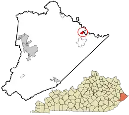 Location in Pike County and the state of Kentucky. | |
| Coordinates: 37°33′52″N 82°8′30″W | |
| Country | United States |
| State | Kentucky |
| County | Pike |
| Area | |
| • Total | 1.21 sq mi (3.13 km2) |
| • Land | 1.21 sq mi (3.13 km2) |
| • Water | 0.00 sq mi (0.00 km2) |
| Elevation | 725 ft (221 m) |
| Population (2020) | |
| • Total | 296 |
| • Density | 245.03/sq mi (94.58/km2) |
| Time zone | Eastern (EST) |
| • Summer (DST) | EST |
| ZIP codes | 41528 |
| FIPS code | 21-29134 |
| GNIS feature ID | 492497[2] |
A post office called Liss was established in the community in 1911. In 1932, it was renamed Freeburn supposedly for a freeburning coal seam fire.[3]
Climate
The climate in this area is characterized by hot, humid summers and generally mild to cool winters. According to the Köppen Climate Classification system, Freeburn has a humid subtropical climate, abbreviated "Cfa" on climate maps.[5]
References
- "2020 U.S. Gazetteer Files". United States Census Bureau. Retrieved March 18, 2022.
- U.S. Geological Survey Geographic Names Information System: Freeburn, Kentucky
- Rennick, Robert M. (1987). Kentucky Place Names. University Press of Kentucky. p. 110. ISBN 0813126312. Retrieved 2013-04-28.
- "Census of Population and Housing". Census.gov. Retrieved June 4, 2016.
- Climate Summary for Freeburn, Kentucky
Municipalities and communities of Pike County, Kentucky, United States | ||
|---|---|---|
| Cities | 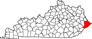 Location of Pike County, Kentucky | |
| CDPs | ||
| Other unincorporated communities |
| |
| Ghost towns | ||
| ||
This article is issued from Wikipedia. The text is licensed under Creative Commons - Attribution - Sharealike. Additional terms may apply for the media files.