Four, Isère
Four (French pronunciation: [fuʁ] (![]() listen)) is a commune in the Isère department in southeastern France.
listen)) is a commune in the Isère department in southeastern France.
Four | |
|---|---|
.JPG.webp) The town hall of Four | |
Location of Four 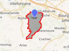 | |
 Four 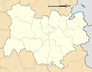 Four | |
| Coordinates: 45°35′17″N 5°11′47″E | |
| Country | France |
| Region | Auvergne-Rhône-Alpes |
| Department | Isère |
| Arrondissement | La Tour-du-Pin |
| Canton | L'Isle-d'Abeau |
| Intercommunality | CA Porte de l'Isère |
| Government | |
| • Mayor (2020–2026) | Jean Papadopulo[1] |
| Area 1 | 11.82 km2 (4.56 sq mi) |
| Population | 1,625 |
| • Density | 140/km2 (360/sq mi) |
| Time zone | UTC+01:00 (CET) |
| • Summer (DST) | UTC+02:00 (CEST) |
| INSEE/Postal code | 38172 /38080 |
| Elevation | 270–529 m (886–1,736 ft) (avg. 330 m or 1,080 ft) |
| 1 French Land Register data, which excludes lakes, ponds, glaciers > 1 km2 (0.386 sq mi or 247 acres) and river estuaries. | |
Population
|
|
See also
References
- "Répertoire national des élus: les maires". data.gouv.fr, Plateforme ouverte des données publiques françaises (in French). 2 December 2020.
- "Populations légales 2019". The National Institute of Statistics and Economic Studies. 29 December 2021.
| Wikimedia Commons has media related to Four (Isère). |
This article is issued from Wikipedia. The text is licensed under Creative Commons - Attribution - Sharealike. Additional terms may apply for the media files.