Forrest, Western Australia
Forrest is a small settlement and railway station on the Trans-Australian Railway in Western Australia. At the 2016 census, no people lived in Forrest,[1] having been recorded at 18 individuals during the 2006 census.[2]
| Forrest Western Australia | |||||||||||||||
|---|---|---|---|---|---|---|---|---|---|---|---|---|---|---|---|
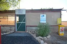 Forrest Airport | |||||||||||||||
 Forrest | |||||||||||||||
| Coordinates | 30°50′53″S 128°06′32″E | ||||||||||||||
| Population | 0 (2016 census)[1] | ||||||||||||||
| Postcode(s) | 6434 | ||||||||||||||
| State electorate(s) | Kalgoorlie | ||||||||||||||
| Federal division(s) | O'Connor | ||||||||||||||
| |||||||||||||||
Forrest was named after Sir John Forrest, the explorer who became the first Premier of Western Australia.[3]
Transport
Forrest is on the longest stretch of straight railway in the world, at 479 km (298 mi) from Nurina in Western Australia to Ooldea in South Australia.
Forrest Airport was the overnight stop on the first scheduled passenger air service between Perth and Adelaide from 1929 to 1934, operated by West Australian Airways. The 18-room hostel provided a restaurant meal "worthy of any city hotel".[4]
Climate
Forrest has a typical arid climate; however it is cooler in summer than much of the Australian desert due to its proximity to the ocean. Despite this, Forrest still holds the record for the equal 6th-hottest temperature in Australia, 49.8 °C (121.6 °F) recorded on 13 January 1979.[5]
| Climate data for Forrest, Australia (averages: 1993–2015; temperature extremes: 1946–2015.note: a standard 30-year data compilation period has not been used) | |||||||||||||
|---|---|---|---|---|---|---|---|---|---|---|---|---|---|
| Month | Jan | Feb | Mar | Apr | May | Jun | Jul | Aug | Sep | Oct | Nov | Dec | Year |
| Record high °C (°F) | 49.8 (121.6) |
47.5 (117.5) |
45.3 (113.5) |
40.1 (104.2) |
36.9 (98.4) |
31.3 (88.3) |
29.7 (85.5) |
34.2 (93.6) |
38.7 (101.7) |
43.3 (109.9) |
44.9 (112.8) |
49.5 (121.1) |
49.8 (121.6) |
| Average high °C (°F) | 33.2 (91.8) |
32.4 (90.3) |
29.2 (84.6) |
26.2 (79.2) |
22.3 (72.1) |
19.1 (66.4) |
18.7 (65.7) |
21.90 (71.42) |
24.5 (76.1) |
27.4 (81.3) |
30.0 (86.0) |
31.4 (88.5) |
26.36 (79.45) |
| Average low °C (°F) | 16.3 (61.3) |
16.7 (62.1) |
14.4 (57.9) |
12.0 (53.6) |
8.9 (48.0) |
6.1 (43.0) |
5.0 (41.0) |
5.8 (42.4) |
8.3 (46.9) |
10.7 (51.3) |
13.1 (55.6) |
14.8 (58.6) |
11.0 (51.8) |
| Record low °C (°F) | 6.6 (43.9) |
6.3 (43.3) |
5.7 (42.3) |
2.3 (36.1) |
−0.5 (31.1) |
−4.3 (24.3) |
−4.5 (23.9) |
−3.3 (26.1) |
−2.1 (28.2) |
0.9 (33.6) |
2.6 (36.7) |
4.6 (40.3) |
−4.5 (23.9) |
| Average rainfall mm (inches) | 25.1 (0.99) |
25.8 (1.02) |
25.2 (0.99) |
18.7 (0.74) |
18.8 (0.74) |
15.6 (0.61) |
15.8 (0.62) |
13.4 (0.53) |
16.4 (0.65) |
10.3 (0.41) |
22.8 (0.90) |
25.1 (0.99) |
233 (9.19) |
| Average rainy days | 4.4 | 3.6 | 5.4 | 5.5 | 6.4 | 7.5 | 6.5 | 4.9 | 4.3 | 4.0 | 4.5 | 4.6 | 61.6 |
| Source: Bureau of Meteorology[6][7][8] | |||||||||||||
References
- Australian Bureau of Statistics (27 June 2017). "Forrest (WA)". 2016 Census QuickStats. Retrieved 19 February 2021.
- Australian Bureau of Statistics (25 October 2007). "Forrest (State Suburb)". 2006 Census QuickStats. Retrieved 9 July 2011.
- Reed, A.W. (1973) Place Names of Australia, Sydney: A.H. & A.W. Reed, ISBN 0-589-07115-7
- "WAA's Magic Carpet" (PDF). Flight Safety Australia. Civil Aviation Safety Authority. September–October 1999. Archived from the original (PDF) on 8 August 2008. Retrieved 21 June 2007.
- "Official records for Australia". Daily Extremes. Bureau of Meteorology. 17 May 2021. Retrieved 25 May 2021.
- "Climate Statistics for Forrest, WA". Bureau of Meteorology. Retrieved 21 December 2015.
- "Climate Statistics for Forrest Aero, WA". Bureau of Meteorology. Retrieved 21 December 2015.
- "Highest daily maximum temperatures for Australia - 19 December 2019". bom.gov.au. Bureau of Meteorology. Retrieved 29 December 2019.