Finchley Gap
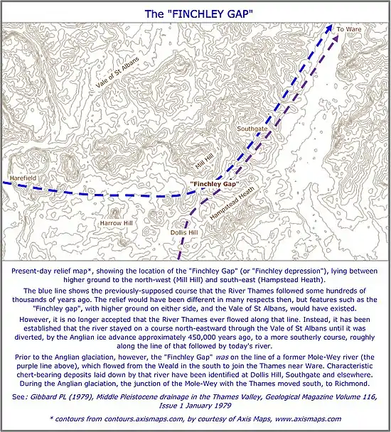
The "Finchley Gap" (or "Finchley depression") is a location in north London which today lies, and which for much of the Pleistocene epoch has lain, between higher ground to the north-west (Mill Hill) and south-east (Hampstead Heath).
The term "Finchley Gap" has been used in archeological literature.[1] "Finchley depression" has been used in geomorphological literature.
Until the 1960s, it was supposed that the River Thames once flowed through the gap, on a loop running from Harefield to Ware.[2]
However, no deposits which were unambiguously of Thames origin were ever found along that line. And subsequent detailed study of deposits in the Vale of St Albans led researchers to the conclusion that the River Thames never flowed through the Finchley Gap. Instead, it was established that the river stayed on a course north-eastward through the Vale of St Albans until it was diverted, by the Anglian ice advance approximately 450,000 years ago, to a more southerly route, roughly along the line of that followed by today's river.[3]
A lobe of the Anglian ice sheet advanced at least as far south as the Finchley Gap. As it melted, it deposited about 14 metres of glacial till there.[4]
Context
On the upper Thames the Goring Gap, a former dip between high hills saw pooling before it – due to glaciation across (blockage to) its northern, shared lower course – the Great Ouse – an icing up of the Vale of Aylesbury. Thus the geologically early upper Thames flowed by a reversed Thame through what today is low, broad wind valley. Some pooling there may well have added to flows of the River Gade and/or River Chess in a later ice age into the deep valley of the uppermost Colne, which ran reversed (west-east) towards the River Lea (or Lee). Later, as cold increased, this channel was blocked by the large ice sheet over Hertfordshire and most of Essex. The Anglian glaciation reached its peak centuries. With its path blocked by ice the river would have ponded back to a periglacial lake. This would have eventually overflowed, wending a new path and valley to the essentially parallel river valley fed by the Kennet and Loddon (the middle or lower Thames).
Any flow along the Finchley gap or spring line was impeded by Anglian glaciation across most or all of Middlesex. Thus the rivers Crane and Ash flow south then east and many southward channels of the lower Colne formed, all to augment the existing separate large river, that is, the modern course of the lower Thames.[5]
Evidence
Evidence of glaciation was extensively gathered by Professor Sidney Wooldridge (1938 and 1960), who dated it to the Anglian Stage glaciation around 450,000 BCE. This left telltale freeze-thaw and boulder clays by valleys as far as Bricket Wood in the northwest, Finchley in the west and Hornchurch at London's east extreme to the southeast.
The deposits reflect the erosion southward during the Quaternary ice age when the northern land was blocked by ice and moraines.
Finchley gap, as a minor rivers connection
Wooldrige suggested the Colne, forced into reverse may have somehow found away to link to the Brent
Dispelling of Finchley gap
Later work matched gravel deposits in the Vale of St Albans with those in the modern lower Thames valley.[6] This suggests that the Finchley overflow route is unlikely and – once ponded back from Rickmansworth by the ice – the formative Colne overflowed more directly into its current route.[7]
The Mutton Brook, Dollis Brook, River Brent channels are more likely to have been cut by melt waters from the lobe of glacial ice that occupied Finchley when the ice sheets were at their maximum extent.
See also
Goring Gap, current route of the Thames, thought to have been a high dip amid the North Wessex Downs
Notes and references
- In, for example: Collins D (1976), The Archaeology of the London area: current knowledge and problems, Issue 1 of Special paper, Volume 1 of Occasional Publications, London and Middlesex Archaeological Society; and Roe DA (2014), The Lower and Middle Palaeolithic Periods in Britain, Volume 46, Routledge, ISBN 9781317600244, page 140.
- This supposition was supported in, for example: Wooldridge SW, Linton DL (1955), Structure, surface and drainage in South-East England, Philip, London; and Holmes A (1965), Principles of physical geology, Nelson, page 709. Holmes estimated that the Thames flowed through the Finchley depression "for perhaps half a million years", from about 1.25m years ago, to about 750,000 years ago.
- See in particular: Gibbard PL (1979), Middle Pleistocene drainage in the Thames Valley, Geological Magazine Volume 116, Issue 1 January 1979; and Bridgland DR (2012), Quaternary of the Thames, Geological Conservation Review Series, Springer Science & Business Media, ISBN 978-94-010-4303-8, ISBN 978-94-011-0705-1 (eBook) (originally published by Chapman and Hall in 1994).
- Ellison RA (2004), Geology of London, British Geological Survey, p58.
- "The early Ice Age". www.geoessex.org.uk. Retrieved 7 February 2016.
- (Moffat and Catt, 1982; Avery and Catt, 1983; Green and McGregor, 1983)
- Bridgland, D.R., (1994), page 5