Fagnières
Fagnières (French pronunciation: [faɲɛʁ]) is a commune in the Marne department in north-eastern France.
Fagnières | |
|---|---|
.svg.png.webp) Coat of arms | |
Location of Fagnières 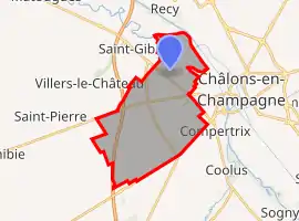 | |
 Fagnières 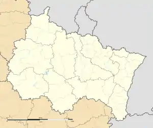 Fagnières | |
| Coordinates: 48°57′51″N 4°19′09″E | |
| Country | France |
| Region | Grand Est |
| Department | Marne |
| Arrondissement | Châlons-en-Champagne |
| Canton | Châlons-en-Champagne-1 |
| Intercommunality | Châlons-en-Champagne |
| Government | |
| • Mayor (2020–2026) | Denis Fenat |
| Area 1 | 19.48 km2 (7.52 sq mi) |
| Population | 4,843 |
| • Density | 250/km2 (640/sq mi) |
| Time zone | UTC+01:00 (CET) |
| • Summer (DST) | UTC+02:00 (CEST) |
| INSEE/Postal code | 51242 /51510 |
| Elevation | 77–122 m (253–400 ft) (avg. 85 m or 279 ft) |
| 1 French Land Register data, which excludes lakes, ponds, glaciers > 1 km2 (0.386 sq mi or 247 acres) and river estuaries. | |
Population
| Year | Pop. | ±% |
|---|---|---|
| 2004 | 4,816 | — |
| 2006 | 4,694 | −2.5% |
| 2007 | 4,606 | −1.9% |
| 2008 | 4,522 | −1.8% |
| 2009 | 4,437 | −1.9% |
| 2010 | 4,420 | −0.4% |
| 2011 | 4,350 | −1.6% |
| 2012 | 4,474 | +2.9% |
| 2013 | 4,604 | +2.9% |
| 2014 | 4,735 | +2.8% |
| 2015 | 4,748 | +0.3% |
| 2016 | 4,830 | +1.7% |
Climate
| Climate data for Châlons-en-Champagne (Fagnières), elevation: 105 m (344 ft), 1981–2010 normals, extremes 1970–present | |||||||||||||
|---|---|---|---|---|---|---|---|---|---|---|---|---|---|
| Month | Jan | Feb | Mar | Apr | May | Jun | Jul | Aug | Sep | Oct | Nov | Dec | Year |
| Record high °C (°F) | 15.9 (60.6) |
20.5 (68.9) |
24.4 (75.9) |
28.7 (83.7) |
32.3 (90.1) |
36.7 (98.1) |
41.8 (107.2) |
41.1 (106.0) |
33.0 (91.4) |
28.2 (82.8) |
21.8 (71.2) |
16.8 (62.2) |
41.8 (107.2) |
| Average high °C (°F) | 5.2 (41.4) |
7.2 (45.0) |
11.5 (52.7) |
15.1 (59.2) |
19.2 (66.6) |
22.4 (72.3) |
25.5 (77.9) |
25.0 (77.0) |
20.7 (69.3) |
15.7 (60.3) |
9.7 (49.5) |
6.2 (43.2) |
15.4 (59.7) |
| Daily mean °C (°F) | 2.9 (37.2) |
3.7 (38.7) |
7.0 (44.6) |
9.7 (49.5) |
13.7 (56.7) |
16.6 (61.9) |
19.1 (66.4) |
18.8 (65.8) |
15.3 (59.5) |
11.5 (52.7) |
6.5 (43.7) |
3.6 (38.5) |
10.7 (51.3) |
| Average low °C (°F) | 0.1 (32.2) |
0.1 (32.2) |
2.5 (36.5) |
4.3 (39.7) |
8.3 (46.9) |
10.8 (51.4) |
12.8 (55.0) |
12.6 (54.7) |
9.9 (49.8) |
7.2 (45.0) |
3.4 (38.1) |
1.1 (34.0) |
6.1 (43.0) |
| Record low °C (°F) | −21.0 (−5.8) |
−14.6 (5.7) |
−12.4 (9.7) |
−5.2 (22.6) |
−0.7 (30.7) |
0.3 (32.5) |
4.0 (39.2) |
3.6 (38.5) |
0.8 (33.4) |
−4.0 (24.8) |
−13.0 (8.6) |
−18.0 (−0.4) |
−21.0 (−5.8) |
| Average precipitation mm (inches) | 49.8 (1.96) |
43.5 (1.71) |
50.2 (1.98) |
48.0 (1.89) |
56.2 (2.21) |
61.1 (2.41) |
56.5 (2.22) |
55.6 (2.19) |
52.6 (2.07) |
61.1 (2.41) |
52.5 (2.07) |
62.2 (2.45) |
649.3 (25.56) |
| Average precipitation days (≥ 1.0 mm) | 10.8 | 9.3 | 10.5 | 9.2 | 10.2 | 9.2 | 8.3 | 7.8 | 8.2 | 9.9 | 10.1 | 11.3 | 114.7 |
| Source: Meteo France[2] | |||||||||||||
See also
References
- "Populations légales 2019". The National Institute of Statistics and Economic Studies. 29 December 2021.
- "FAGNIERES–INRA (51)" (PDF). Fiche Climatologique: Statistiques 1981–2010 et records (in French). Meteo France. Retrieved 7 August 2019.
| Wikimedia Commons has media related to Fagnières. |
This article is issued from Wikipedia. The text is licensed under Creative Commons - Attribution - Sharealike. Additional terms may apply for the media files.