Eyragues
Eyragues (French pronunciation: [ɛʁaɡ]; Occitan: Irago en Prouvenço) is a commune in the Bouches-du-Rhône department in southern France. Located 14 km (8.7 mi) south of Avignon, and 6 km (3.7 mi) north of St. Rémy-de-Provence, it has a weekly market on Fridays in the large village square.
Eyragues | |
|---|---|
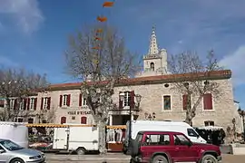 The marketplace in Eyragues | |
.svg.png.webp) Coat of arms | |
Location of Eyragues 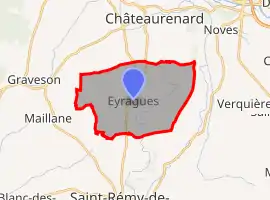 | |
 Eyragues  Eyragues | |
| Coordinates: 43°50′31″N 4°50′30″E | |
| Country | France |
| Region | Provence-Alpes-Côte d'Azur |
| Department | Bouches-du-Rhône |
| Arrondissement | Arles |
| Canton | Châteaurenard |
| Government | |
| • Mayor (2020–2026) | Max Gilles[1] |
| Area 1 | 20.78 km2 (8.02 sq mi) |
| Population | 4,496 |
| • Density | 220/km2 (560/sq mi) |
| Time zone | UTC+01:00 (CET) |
| • Summer (DST) | UTC+02:00 (CEST) |
| INSEE/Postal code | 13036 /13630 |
| Elevation | 11–99 m (36–325 ft) (avg. 23 m or 75 ft) |
| 1 French Land Register data, which excludes lakes, ponds, glaciers > 1 km2 (0.386 sq mi or 247 acres) and river estuaries. | |
Population
|
|
References
- "Répertoire national des élus: les maires". data.gouv.fr, Plateforme ouverte des données publiques françaises (in French). 2 December 2020. Retrieved 7 December 2020.
- "Populations légales 2019". The National Institute of Statistics and Economic Studies. 29 December 2021.
| Wikimedia Commons has media related to Eyragues. |
This article is issued from Wikipedia. The text is licensed under Creative Commons - Attribution - Sharealike. Additional terms may apply for the media files.