Bhimber District
The Bhimber District (Urdu: ضلع بھمبر) is the southernmost district of the 10 districts of Pakistan's dependent territory of Azad Kashmir. It has an area of 1516 km², and the district headquarter is the town of Bhimber.
Bhimber District
ضلع بھمبر | |
|---|---|
| Bhimber | |
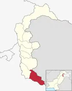 Map of Azad Kashmir with the Bhimber District highlighted in red | |
| Country | Pakistan |
| Territory | Azad Kashmir |
| Division | Mirpur Division |
| Headquarters | Bhimber |
| Government | |
| • Type | District Administration |
| • Deputy Commissioner | N/A |
| • District Police Officer | N/A |
| • District Health Officer | N/A |
| Area | |
| • Total | 1,516 km2 (585 sq mi) |
| Population (2017) | |
| • Total | 420,624 |
| • Density | 277/km2 (720/sq mi) |
| Languages | |
| • Official | Urdu |
| • Spoken | |
| Number of Tehsils | 3 |
History
The area is rich in archeological remains due to its strategic location on the route that was followed by the Mughal emperors on their frequent visits to the Kashmir Valley.
It is strategically important from defense and military standpoint. Due to its location, it became known as the Gateway to Kashmir (Bab-e-Kashmir).
Previously, Bhimber was a tehsil of the Mirpur District but was elevated to district status in 1996.
Location
The Bhimber District is bounded on the north by the Kotli District, on the east by the Rajouri District and the Jammu District of Indian-administered Jammu and Kashmir, on the south by the Gujrat District of Pakistan's Punjab Province, and on the west by the Mirpur District. The town of Bhimber is 50 km from the city of Mirpur.
Administrative divisions
The Bhimber District is subdivided into three tehsils:[1]
- Barnala Tehsil
- Bhimber Tehsil
- Samahni Tehsil
Demography
According to the 2017 census, the population of the district is 420,624.[2]
The main native languages are Punjabi (according to a rough estimate, spoken by 35% of the population), Pahari-Pothwari (30%), Dogri (30%) and Gujari (5%).[3][4] Urdu has official status.
Education
According to the Alif Ailaan Pakistan District Education Rankings 2015, the Bhimber District ranked 10th out of 145 districts in Pakistan and its two dependent territories in terms of education. For facilities and infrastructure, the district ranked 116 out of 145.[5]
Climate
The southern zone of the Mirpur Division has a climate similar to the neighbouring areas of the Punjab province. Hot summer temperatures are often over 45 C from May to September. Winters are cold, and rainfall is concentrated in the monsoon season from late June to the end of August. There is often a prolonged dry period from October to early January, followed by winter rains from mid-January to March.
Notes
References
- "Tehsils of Bhimber District on AJK map". ajk.gov.pk. AJK Official Portal. Retrieved 17 November 2019.
- "Census 2017: AJK population rises to over 4m". The Nation. Retrieved 2017-09-01.
- Statistical Year Book 2020 (PDF). Muzaffarabad: AJ&K Bureau Of Statistics. p. 140. Retrieved 3 March 2022.
- Shakil, Mohsin (2012). "Languages of Erstwhile State of Jammu Kashmir (A Preliminary Study)". p. 12.
- "Individual district profile link, 2015". Alif Ailaan. Archived from the original on 2016-03-04. Retrieved 2015-05-06.
External links
| Wikimedia Commons has media related to Bhimber District. |
 Azad Kashmir travel guide from Wikivoyage
Provincial capital: Muzaffarabad | ||
| Mirpur | 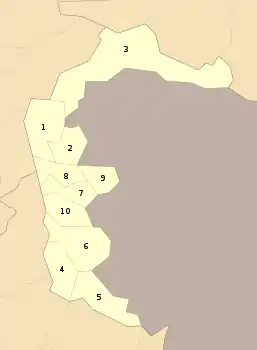 | |
| Muzaffarabad | ||
| Poonch | ||