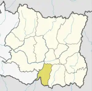
Dharan
Dharan (Devanāgarī: धरान) is a sub-metropolitan city in Sunsari District of Province No. 1, Nepal, which was established as a fourth municipality in the Kingdom in 1958. It is the third most populous city in Eastern Nepal after Biratnagar and Itahari. Dharan is the location of the former Vijayapur, the seat of a historical Limbuwan kingdom, which was later used by the Sen kings of Makwanpur.[1][2] Dharan has an estimated city population of 173,096 living in 34,834 households as per 2021 Nepal census. It is one of the cities of the Greater Birat Development Area which incorporates the cities of Biratnagar-Itahari-Gothgau-Biratchowk-Dharan[3] primarily located on the Koshi Highway in Eastern Nepal, with an estimated total urban agglomerated population of 804,300 people living in 159,332 households.[4]
Dharan
धरान उपमहानगरपालिका | |
|---|---|
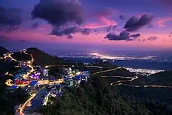 Evening view of Dharan sub metro city from height point of Bhedetar. | |
| Motto(s): "To build an environmentally sound city, functioning as the centre of education, health, tourism and business with fully developed infrastructure" | |
 Dharan  Dharan | |
| Coordinates: 26°49′0″N 87°17′0″E | |
| Country | |
| Province | Province No. 1 |
| District | Sunsari |
| First Settled | 1902 |
| Established | 1958 |
| Upgraded to Sub-metropolitan city | 2017 |
| Founded by | Ratna Prasad Shrestha |
| No. of Wards | 20 |
| Government | |
| • Mayor | Mr. Tilak Rai (NC) |
| • Deputy Mayor | Mrs. Manju Bhandari (Subedi) (NCP) |
| Area | |
| • Total | 74.26 sq mi (192.32 km2) |
| • Water | 1.7 sq mi (4.4 km2) |
| Highest elevation (Near Bhedetar) | 5,833 ft (1,778 m) |
| Lowest elevation (at Tarahara) | 390 ft (119 m) |
| Population (2021) | |
| • Total | 173,096 |
| • Rank | 15th (Nepal) 3rd (Province No. 1) |
| • Density | 2,300/sq mi (900/km2) |
| • Ethnicities | Limbu Rai Bahun Chhetri Newars Magars Gurungs |
| Languages | |
| • Official | Nepali |
| • Additional | English |
| Time zone | UTC+5:45 (NST) |
| Postal Code | 56700 (Sunsari), 56702 (Mangalbare) |
| Telephone code | 025 |
| Climate | Cwa |
| Website | www |
Geography
Dharan is situated on the foothills of the Mahabharat Range in the north with its southern tip touching the edge of the Terai region at an altitude of 1148 ft (349m). The Koshi highway runs through the heart of the city thus connecting it with the provincial capital of Biratnagar as well as the Itahari junction of the east–west Mahendra highway (lying 41 km and 17 km south, respectively), and the Nepal-China border of Kimathanka (lying 115 km north).
Environment
A study conducted in 2016 to analyze the bacteriological quality of bottled drinking water and that of municipal tap water in Dharan found that one hundred percent of the tap water samples and 87.5% of the bottled water samples were contaminated with heterotrophic bacteria. Of the tap water samples, 55.3% were positive for total coliforms, compared with 25% of the bottled water, but no bottled water samples were positive for fecal coliforms and fecal streptococci, in contrast to 21.1% and 14.5% of the tap water samples being contaminated with fecal coliforms and fecal streptococci, respectively. One hundred percent of the tap water samples and 54.2% of the bottled water samples had pH in the acceptable range.[5]
Tourist attractions
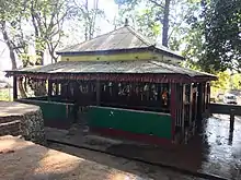
- Budha Subba: As an important and unique religious site to Nepali Hindus, this temple holds immense cultural significance to the people of Dharan.[6] Budha Subba temple is located a top the Bijaypur hills and the surrounding area is highly scenic. This temple holds historic significance because it is the tomb of the last Limbu King, Buddhi Karnaraya Khebang.[7]
- Gurkha Memorial Park: This park was established "to preserve the legacy of Brigade of Gurkhas in Dharan for posterity before it is forgotten and lost forever",[8] as many Nepalese men, many of whom were residents of Dharan, joined the Brigade of Gurkhas.
- Dharan Clock Tower
Media and communication
- Newspapers: The people of Dharan are served by several daily local newspapers and national newspapers. There are 11 local newspapers in total. These include The Blast Times and The Morning Times. National newspapers are also provided to the people of Dharan on a daily basis. National newspapers include The Kathmandu Post, Kantipur, Annapurna Post,[9][10] and Himalayan Times. Several monthly neighborhood papers serve the town.
- Radio: The state-owned Radio Nepal is broadcast on the medium wave on 648 kHz in the city. Five private local FM stations are available. They are Star FM - 95.6 MHz, Vijayapur FM - 98.8 MHz, Dantakali FM - 88.5 MHz, and Radio Dharan FM - 88.8 MHz. Radio Ganatantra FM 95.1 MHz is a community radio station. Likewise, Dharan has a BFBS Radio Relay station. It broadcasts on FM frequencies.
- Television: Nepal's state-owned television broadcaster, Nepal Television's relay station is present near its border, which provides two free-to-air terrestrial channels. A mix of Nepali, Hindi, English, and other international channels are accessible via cable subscription and direct-broadcast satellite services. Dharan Cable Network broadcasts Kriti Television Channel as a local television channel that covers events in the city.
Climate
| Climate data for Dharan (1981-2010) | |||||||||||||
|---|---|---|---|---|---|---|---|---|---|---|---|---|---|
| Month | Jan | Feb | Mar | Apr | May | Jun | Jul | Aug | Sep | Oct | Nov | Dec | Year |
| Record high °C (°F) | 31.0 (87.8) |
35.0 (95.0) |
37.8 (100.0) |
39.4 (102.9) |
39.1 (102.4) |
37.9 (100.2) |
39.4 (102.9) |
39.0 (102.2) |
38.3 (100.9) |
36.7 (98.1) |
35.0 (95.0) |
31.7 (89.1) |
39.4 (102.9) |
| Average high °C (°F) | 24.5 (76.1) |
26.4 (79.5) |
29.6 (85.3) |
30.5 (86.9) |
31.0 (87.8) |
31.5 (88.7) |
31.4 (88.5) |
31.9 (89.4) |
31.5 (88.7) |
30.9 (87.6) |
29.1 (84.4) |
26.1 (79.0) |
29.6 (85.3) |
| Average low °C (°F) | 12.1 (53.8) |
14.1 (57.4) |
17.7 (63.9) |
21.0 (69.8) |
23.0 (73.4) |
24.6 (76.3) |
25.1 (77.2) |
25.2 (77.4) |
24.6 (76.3) |
22.9 (73.2) |
18.6 (65.5) |
13.9 (57.0) |
20.4 (68.7) |
| Record low °C (°F) | 3.3 (37.9) |
2.8 (37.0) |
8.3 (46.9) |
13.2 (55.8) |
15.6 (60.1) |
19.3 (66.7) |
19.0 (66.2) |
19.4 (66.9) |
16.8 (62.2) |
14.4 (57.9) |
10.6 (51.1) |
4.4 (39.9) |
5.0 (41.0) |
| Average precipitation mm (inches) | 12.1 (0.48) |
44.2 (1.74) |
229.3 (9.03) |
258.1 (10.16) |
460.7 (18.14) |
612.0 (24.09) |
503.2 (19.81) |
427.7 (16.84) |
366.5 (14.43) |
168.7 (6.64) |
33.3 (1.31) |
12.8 (0.50) |
3,128.6 (123.17) |
| Average rainy days | 1.0 | 3.9 | 8.5 | 12.6 | 16.2 | 21.5 | 22.5 | 19.3 | 15.5 | 7.7 | 2.4 | 0.6 | 131.6 |
| Source: Meteorological Department of Nepal (record high and low up to 2010)[11][12] | |||||||||||||
Notable people
- Bhola Rijal, Doctor and lyricist
- Deep Shrestha, Singer and music composer
- Deepak Limbu, Singer
- Dhiraj Rai, Singer
- Govinda Subba, First governor of province no. 1 (Nepal)
- Hari Nath Bastola, Politician
- Krishna Kumar Rai, Politician
- Malina Joshi, Miss Nepal 2011
- Malvika Subba, Miss Nepal 2002
- Minendra Rijal, Politician & MP
- Namrata Shrestha, Actress
- Raju Kaji Shakya, Former captain of national football team
- Sabin Rai, Singer
- Subin Limbu, Miss Nepal 2014
References
- Sugden, Fraser; Gurung, Ganesh (2012), Absentee landordism and agrarian stagnation in Nepal: A case from the Eastern Tarai, Nepal Institute of Development Studies, p. 30, ISBN 9789937857000
- Regmi Research Series, 1979, p. 11
- "Capital of Province 1 to be scattered in various districts". Archived from the original on 13 May 2021.
- "Archived copy". censusnepal.cbs.gov.np. Archived from the original on 27 January 2022. Retrieved 22 February 2022.
{{cite web}}: CS1 maint: archived copy as title (link) - Pant, Narayan Dutt; Poudyal, Nimesh; Bhattacharya, Shyamal Kumar (7 June 2016). "Bacteriological quality of bottled drinking water versus municipal tap water in Dharan municipality, Nepal". Journal of Health, Population, and Nutrition. 35 (1): 17. doi:10.1186/s41043-016-0054-0. ISSN 2072-1315. PMC 5025974. PMID 27267213.
- Aayush (12 August 2019). "Budhasubba Temple -believed it brings good luck". Wonders of Nepal. Archived from the original on 13 April 2021. Retrieved 24 March 2021.
- "Budha Subba Temple- Dharan, Nepal". Hopnepal.com. Archived from the original on 1 March 2021. Retrieved 24 March 2021.
- "Archived copy" (PDF). Archived (PDF) from the original on 13 April 2021. Retrieved 25 March 2021.
{{cite web}}: CS1 maint: archived copy as title (link) - "HugeDomains.com - Clickdharan.com is for sale (Clickdharan)". www.clickdharan.com. Archived from the original on 16 November 2017. Retrieved 8 September 2018.
{{cite web}}: Cite uses generic title (help) - "Archived copy". Archived from the original on 20 June 2018. Retrieved 27 November 2019.
{{cite web}}: CS1 maint: archived copy as title (link) - "Silchar Climatological Table Period: 1971–2000". India Meteorological Department. Archived from the original on 27 April 2015. Retrieved 27 April 2015.
- "Ever recorded maximum and minimum temperatures up to 2010" (PDF). India Meteorological Department. Archived from the original (PDF) on 21 May 2013. Retrieved 27 April 2015.